Periyar channels
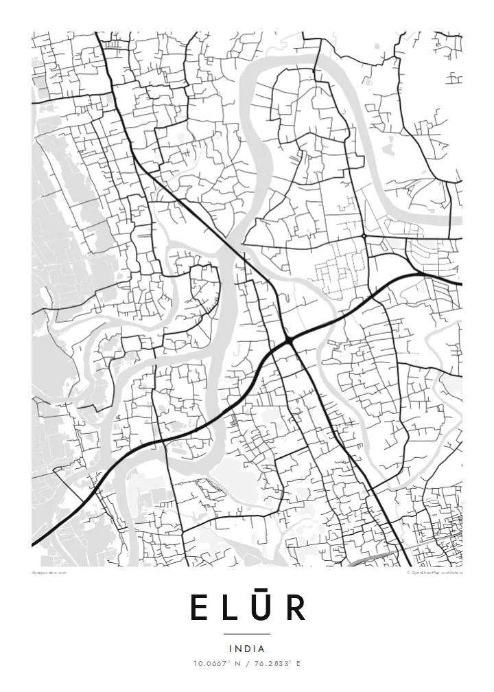
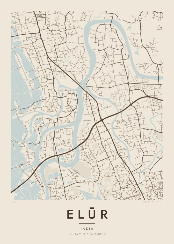
Branches of the Periyar enclose the town on several sides, giving the map a clear island outline and a strong contrast between water and land.
Postè kat minimalis · India
10.0667° N / 76.2833° E
A river island north of Kochi, its roads and factories enclosed by branches of the Periyar


Yon vil, senk atmosfè
Peze yon style pou wè li sou mi a. Chak style koute menm pri — enprime, ankadre oswa kòm fichye HD.
 Piksèl reyèl · fichye enpresyon 24 × 36″
Byen klè pou enprime
Sa a se yon zoom 100% sou vrè fichye enpresyon an. Chak afich — enprime, ankadre oswa telechaje — jenere sou sèvè nou yo nan 300 DPI, jiska 7,200 × 10,800 piksèl, konsa menm pi piti wout yo rete klè sou yon enpresyon 24 × 36″.
Sou mi a


Kat la
Elūr, often written Eloor, is one of the more striking shapes on the map of central Kerala. It occupies an island formed where the Periyar river divides on its way to the backwaters, so that water wraps around almost every edge of the town. Roads cross the channels by bridge, and inside the island the street pattern is irregular, shaped by riverbanks, plots and industrial compounds.
The town lies within the wider Kochi urban region and has long been one of Kerala's main industrial centres. Large chemical and fertiliser plants occupy substantial parts of the land, and on the map they appear as broad blocks with internal roads, set beside dense residential lanes and patches of coconut and green along the water.
An Elūr map poster makes the most of that island outline: a town defined by the river that surrounds it, with the lines of the Periyar framing the streets like a border. It is a quiet, distinctive image, recognisable at once to anyone who knows the area.
Branches of the Periyar enclose the town on several sides, giving the map a clear island outline and a strong contrast between water and land.
Large factory compounds form wide, regular shapes within the island, their grid of internal roads distinct from the looser residential lanes around them.
A handful of bridge crossings link the island to the surrounding towns of greater Kochi, drawn as short, decisive lines across the river.
Fè l pou ou
Ajoute yon dat, yon non oswa pwòp fraz pa w, chanje estil, gwosè oswa oryantasyon.
Apèsi gratis la se nan rezolisyon ba avèk yon watèrmak. Enpresyon ak fichye HD yo jenere nan 300 DPI, jiska 7,200 × 10,800 px, san watèrmak.
Poukisa Elūr
For people who grew up on the island or worked in its plants, Elūr is defined by the river as much as by any street. A map shows that relationship at a glance and makes a considered gift for family members living elsewhere in India or abroad.
The title, subtitle and coordinates line are yours to edit, so the poster can carry a family name or a year. Five styles are available, Classic black and white, Noir, Paper, Blueprint and Sand, as $9 HD downloads or matte prints shipped from local partners.
Kòmande afich Elūr a| Gwosè enpresyon | Rezolisyon | Fichye |
|---|---|---|
| 30 × 40 cm (11.8 × 15.7″) | 3,543 × 4,724 px | PNG · PDF |
| 29.7 × 42 cm (A3, 11.7 × 16.5″) | 3,508 × 4,961 px | PNG · PDF |
| 42 × 59.4 cm (A2, 16.5 × 23.4″) | 4,961 × 7,016 px | PNG · PDF |
| 45.7 × 61 cm (18 × 24″) | 5,400 × 7,200 px | PNG · PDF |
| 50 × 70 cm (19.7 × 27.6″) | 5,906 × 8,268 px | PNG · PDF |
| 61 × 91.4 cm (24 × 36″) | 7,200 × 10,800 px | PNG · PDF |
Pou konpare, apèsi gratis la gen 900 px lajè, li gen filigràn epi li fèt pou ekran. Fichye HD yo gen jiska 8 fwa plis rezolisyon nan chak direksyon epi yo enprime pwòp nan gwosè postè konplè.
Chwazi yon style anlè paj la, epi chwazi Afich Enprime — yon gwosè epi, si w vle, yon kad — oswa Fichye Dijital HD. Peman an fèt nan yon sèl etap, epi paj kòmand ou a mete ajou kou peman an konfime.
Li enprime sou papye mat premium 200 gsm nan youn nan sis gwosè, soti nan 30 × 40 cm rive nan 24 × 36″. Afich enprime yo kòmanse nan $39, livrezon enkli.
Wi. Chwazi yon kad an bwa solid nan koulè nwa, blan, chenn natirèl oswa bwa fonse. Li vin ak yon vit ki pa kase epi li pare pou pandye. Afich ankadre yo kòmanse nan $99, livrezon enkli.
Livrezon an gratis nan tout mond lan. Se pi pwòch nan patnè enprimri nou yo nan plis pase 30 peyi ki enprime chak afich la, epi li anjeneral rive nan 3–7 jou ouvrab. Ou ka swiv estati ak swivi kolis la nan Kòmand mwen yo. Gen kèk peyi ki pran 2–5 semèn, e kote nou poko livre a, sit la di w anvan ou peye.
Voye nou yon foto nan 14 jou apre livrezon an epi nou ap reenprime li gratis oswa remèt ou lajan w.
Wi. Nan editè a sou paj sa a, chanje tit la, soutit la ak liy kowòdone yo pou nenpòt sa w vle, epi chwazi yon style ak yon gwosè. Kòmand enprime, ankadre ak dijital yo tout itilize egzakteman desen w lan.
Pou $9 ou jwenn fichye PNG 300 DPI ak PDF pare-pou-enprime nan tout sis gwosè yo, san watèrmak, pou enprime kote w vle. Pa sèten toujou? Telechaje yon apèsi gratis ak watèrmak anvan.
