Great Belt link
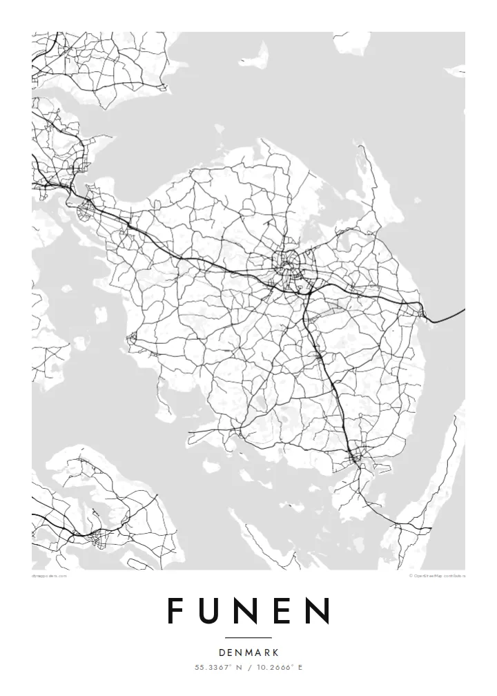
The fixed link to Zealand leaves Funen's east coast near Nyborg and crosses the strait by way of the small island of Sprogø. On the map it is a long, straight line across open water.
Postè kat minimalis · Denmark
55.3367° N / 10.2666° E
A broad, rounded Danish island between two straits, with Odense near its centre and an archipelago scattered off its southern coast


Yon vil, senk atmosfè
Peze yon style pou wè li sou mi a. Chak style koute menm pri — enprime, ankadre oswa kòm fichye HD.
 Piksèl reyèl · fichye enpresyon 24 × 36″
Byen klè pou enprime
Sa a se yon zoom 100% sou vrè fichye enpresyon an. Chak afich — enprime, ankadre oswa telechaje — jenere sou sèvè nou yo nan 300 DPI, jiska 7,200 × 10,800 piksèl, konsa menm pi piti wout yo rete klè sou yon enpresyon 24 × 36″.
Sou mi a


Kat la
Funen lies between Jutland and Zealand, and on a map it sits squarely in the middle of Denmark, with the Little Belt to the west and the Great Belt to the east. The island is broad and compact. Country roads cross gently rolling farmland, small towns are spaced evenly across the land, and the coastline is cut by shallow fjords and bays.
Odense, the island's largest city and one of the oldest in Denmark, sits near the centre. Ring roads surround its historic core, and a canal leads north to Odense Fjord. The city is the birthplace of Hans Christian Andersen. Bridges carry road and rail west to Jutland, and the long Great Belt link runs east toward Zealand.
South of the island lies the South Funen Archipelago, with Tåsinge, Ærø and many smaller islands reached by bridge and ferry. Castles and manor estates are scattered across the countryside, among them Egeskov with its moat. A Funen map poster shows the island as a hub: the city at the centre, bridges on either side and islands trailing off to the south.
The fixed link to Zealand leaves Funen's east coast near Nyborg and crosses the strait by way of the small island of Sprogø. On the map it is a long, straight line across open water.
At the heart of the island, ring roads enclose Odense's old centre. The river Odense Å winds through it and through parks, and a canal carries on north to the fjord.
Off the south coast, a scatter of islands and islets breaks up the water around Svendborg Sound. It turns the bottom of the map into a mosaic of small coastlines.
Fè l pou ou
Ajoute yon dat, yon non oswa pwòp fraz pa w, chanje estil, gwosè oswa oryantasyon.
Apèsi gratis la se nan rezolisyon ba avèk yon watèrmak. Enpresyon ak fichye HD yo jenere nan 300 DPI, jiska 7,200 × 10,800 px, san watèrmak.
Poukisa Funen
This is a map for people from Odense, Svendborg or the small towns in between, and for anyone who thinks of Funen as the green middle of Denmark. The rounded shape, the bridges and the southern islands give the print a pleasing balance.
You can personalise the title, subtitle and coordinates, add a date that matters to you, and choose one of five styles. The $9 digital files cover six sizes, including 50×70 cm and A2, each as a 300 DPI PNG and a print-ready PDF.
Kòmande afich Funen a| Gwosè enpresyon | Rezolisyon | Fichye |
|---|---|---|
| 30 × 40 cm (11.8 × 15.7″) | 3,543 × 4,724 px | PNG · PDF |
| 29.7 × 42 cm (A3, 11.7 × 16.5″) | 3,508 × 4,961 px | PNG · PDF |
| 42 × 59.4 cm (A2, 16.5 × 23.4″) | 4,961 × 7,016 px | PNG · PDF |
| 45.7 × 61 cm (18 × 24″) | 5,400 × 7,200 px | PNG · PDF |
| 50 × 70 cm (19.7 × 27.6″) | 5,906 × 8,268 px | PNG · PDF |
| 61 × 91.4 cm (24 × 36″) | 7,200 × 10,800 px | PNG · PDF |
Pou konpare, apèsi gratis la gen 900 px lajè, li gen filigràn epi li fèt pou ekran. Fichye HD yo gen jiska 8 fwa plis rezolisyon nan chak direksyon epi yo enprime pwòp nan gwosè postè konplè.
Chwazi yon style anlè paj la, epi chwazi Afich Enprime — yon gwosè epi, si w vle, yon kad — oswa Fichye Dijital HD. Peman an fèt nan yon sèl etap, epi paj kòmand ou a mete ajou kou peman an konfime.
Li enprime sou papye mat premium 200 gsm nan youn nan sis gwosè, soti nan 30 × 40 cm rive nan 24 × 36″. Afich enprime yo kòmanse nan {printFrom}, livrezon enkli.
Wi. Chwazi yon kad an bwa solid nan koulè nwa, blan, chenn natirèl oswa bwa fonse. Li vin ak yon vit ki pa kase epi li pare pou pandye. Afich ankadre yo kòmanse nan {framedFrom}, livrezon enkli.
Livrezon gratis toupatou nan mond lan. Chak afich enprime nan patnè enpresyon ki pi pre nan plis pase 30 peyi, e li rive jeneralman nan 3–7 jou ouvrab. Ou ka swiv estati ak suivi anba My Orders.
Voye nou yon foto nan 14 jou apre livrezon an epi nou ap reenprime li gratis oswa remèt ou lajan w.
Wi. Nan editè a sou paj sa a, chanje tit la, soutit la ak liy kowòdone yo pou nenpòt sa w vle, epi chwazi yon style ak yon gwosè. Kòmand enprime, ankadre ak dijital yo tout itilize egzakteman desen w lan.
Pou $9 ou jwenn fichye PNG 300 DPI ak PDF pare-pou-enprime nan tout sis gwosè yo, san watèrmak, pou enprime kote w vle. Pa sèten toujou? Telechaje yon apèsi gratis ak watèrmak anvan.
