Public Square crossroads
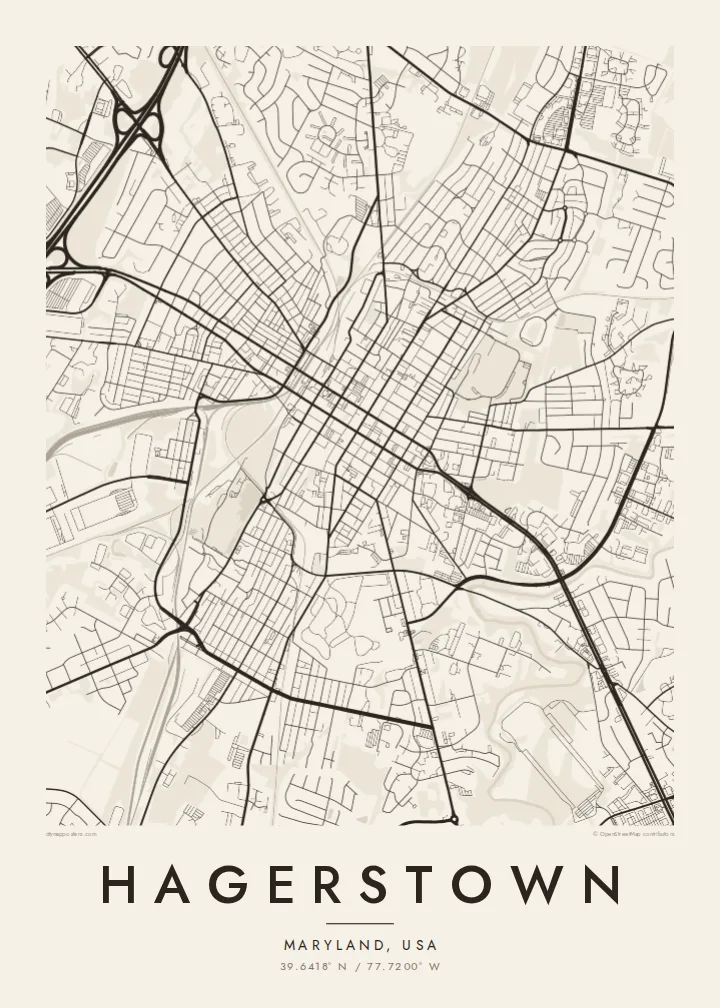
The downtown grid is organised around Public Square, where the city's two main streets meet. It is the historic centre and the point from which the map unfolds.
Postè kat minimalis · United States
39.6418° N / 77.7200° W
A historic grid centred on Public Square, where two interstates meet in the Cumberland Valley of western Maryland




Yon vil, senk atmosfè
Peze yon style pou wè li sou mi a. Chak style koute menm pri — enprime, ankadre oswa kòm fichye HD.
 Piksèl reyèl · fichye enpresyon 24 × 36″
Byen klè pou enprime
Sa a se yon zoom 100% sou vrè fichye enpresyon an. Chak afich — enprime, ankadre oswa telechaje — jenere sou sèvè nou yo nan 300 DPI, jiska 7,200 × 10,800 piksèl, konsa menm pi piti wout yo rete klè sou yon enpresyon 24 × 36″.
Sou mi a


Kat la
Hagerstown was founded in the eighteenth century by Jonathan Hager and grew into the county seat of Washington County, Maryland. Its downtown follows a regular grid of streets meeting at Public Square, where the two main streets cross. From that point the grid extends in every direction before loosening into later neighbourhoods and commercial strips.
The city is nicknamed the Hub City because of the railroads that once converged here, and today Interstates 70 and 81 cross just outside town. Nearby lie the Antietam battlefield and the Appalachian Trail, and City Park, with its lake and art museum, forms a green area close to downtown.
A Hagerstown map poster brings out the clarity of the old grid alongside the curving highways and rail lines that made the city a crossroads. The square downtown blocks, the park and the lines of transport give the design balance and a strong sense of history, all in the calm language of black and white.
The downtown grid is organised around Public Square, where the city's two main streets meet. It is the historic centre and the point from which the map unfolds.
Railroad lines sweep through the city, remnants of the network that gave Hagerstown its nickname. They cut across the grid in long curves that add movement to the map.
City Park, with its lake and museum, forms a large open shape close to downtown, softening the grid and giving the composition a place to rest.
Fè l pou ou
Ajoute yon dat, yon non oswa pwòp fraz pa w, chanje estil, gwosè oswa oryantasyon.
Apèsi gratis la se nan rezolisyon ba avèk yon watèrmak. Enpresyon ak fichye HD yo jenere nan 300 DPI, jiska 7,200 × 10,800 px, san watèrmak.
Poukisa Hagerstown
A Hagerstown map suits people who grew up in the Cumberland Valley, alumni of local schools, or history lovers drawn to western Maryland. Add a family name, a founding year or a wedding date to the title for a personal touch.
Pick a style from Classic black & white, Noir, Paper, Blueprint and Sand. Printed posters on matte paper, with an optional wooden frame, are shipped from partners in over 30 countries, or you can download HD files for $9.
Kòmande afich Hagerstown a| Gwosè enpresyon | Rezolisyon | Fichye |
|---|---|---|
| 30 × 40 cm11.8 × 15.7″ | 3,543 × 4,724 px | PNG · PDF |
| 29.7 × 42 cm (A3)11.7 × 16.5″ | 3,508 × 4,961 px | PNG · PDF |
| 42 × 59.4 cm (A2)16.5 × 23.4″ | 4,961 × 7,016 px | PNG · PDF |
| 45.7 × 61 cm18 × 24″ | 5,400 × 7,200 px | PNG · PDF |
| 50 × 70 cm19.7 × 27.6″ | 5,906 × 8,268 px | PNG · PDF |
| 61 × 91.4 cm24 × 36″ | 7,200 × 10,800 px | PNG · PDF |
Pou konpare, apèsi gratis la gen 900 px lajè, li gen filigràn epi li fèt pou ekran. Fichye HD yo gen jiska 8 fwa plis rezolisyon nan chak direksyon epi yo enprime pwòp nan gwosè postè konplè.
Chwazi yon style anlè paj la, epi chwazi Afich Enprime — yon gwosè epi, si w vle, yon kad — oswa Fichye Dijital HD. Peman an fèt nan yon sèl etap, epi paj kòmand ou a mete ajou kou peman an konfime.
Li enprime sou papye mat premium 200 gsm nan youn nan sis gwosè, soti nan 30 × 40 cm rive nan 24 × 36″. Afich enprime yo kòmanse nan $39, livrezon enkli.
Wi. Chwazi yon kad an bwa solid nan koulè nwa, blan, chenn natirèl oswa bwa fonse. Li vin ak yon vit ki pa kase epi li pare pou pandye. Afich ankadre yo kòmanse nan $99, livrezon enkli.
Livrezon gratis nan plis pase 60 peyi. Chak afich enprime pa patnè enprimeri ki pi pre w la nan plis pase 30 peyi, e anjeneral li rive nan 3 a 7 jou ouvrab. Ou ka suiv estati a ak swivi kolis la nan Kòmand mwen yo. Kèk peyi pran 2 a 5 semèn, e kote nou poko livre, sit la di w sa anvan w peye.
Voye nou yon foto nan 14 jou apre livrezon an epi nou ap reenprime li gratis oswa remèt ou lajan w.
Wi. Nan editè a sou paj sa a, chanje tit la, soutit la ak liy kowòdone yo pou nenpòt sa w vle, epi chwazi yon style ak yon gwosè. Kòmand enprime, ankadre ak dijital yo tout itilize egzakteman desen w lan.
Pou $9 ou jwenn fichye PNG 300 DPI ak PDF pare-pou-enprime nan tout sis gwosè yo, san watèrmak, pou enprime kote w vle. Pa sèten toujou? Telechaje yon apèsi gratis ak watèrmak anvan.
Toupre
