Sullivans Cove
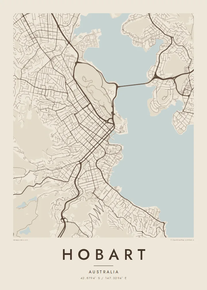
The harbour where Hobart began. On the map, its docks and wharves form a small, precise shape at the foot of the central grid, next to Salamanca Place and Battery Point.
Postè kat minimalis · Australia
42.8794° S / 147.3294° E
Streets climbing from the Derwent estuary toward kunanyi, with a long bridge and a small historic harbour at the centre


Yon vil, senk atmosfè
Peze yon style pou wè li sou mi a. Chak style koute menm pri — enprime, ankadre oswa kòm fichye HD.
 Piksèl reyèl · fichye enpresyon 24 × 36″
Byen klè pou enprime
Sa a se yon zoom 100% sou vrè fichye enpresyon an. Chak afich — enprime, ankadre oswa telechaje — jenere sou sèvè nou yo nan 300 DPI, jiska 7,200 × 10,800 piksèl, konsa menm pi piti wout yo rete klè sou yon enpresyon 24 × 36″.
Sou mi a


Kat la
Hobart occupies the western shore of the Derwent River estuary, below the mass of kunanyi / Mount Wellington, which rises to about 1,270 metres. From above, the city is squeezed into a band between water and mountain. Streets start at the harbour in a regular grid, then bend and thin out as they climb into the steep, wooded slopes behind.
Founded in 1804, Hobart is Australia's second-oldest capital city. The early town grew around Sullivans Cove, where Salamanca Place still keeps a row of sandstone warehouses, and the small streets of Battery Point climb the headland beside it. Across the estuary, the eastern shore is linked by the Tasman Bridge, a long, slender line on the map.
A Hobart map poster makes the geography unusually legible. The estuary opens wide to the south, the mountain leaves a large quiet space to the west, and the city fits between them. Suburbs follow the river north toward Glenorchy and beyond, while the headlands and bays along the shore give the edge of the map a detailed, irregular outline.
The harbour where Hobart began. On the map, its docks and wharves form a small, precise shape at the foot of the central grid, next to Salamanca Place and Battery Point.
A long bridge crossing the Derwent to the eastern shore. Its straight line over the wide estuary is one of the clearest single features of the whole composition.
The mountain west of the city leaves a broad area with few streets. Roads wind up toward it, and the grid fades into curving lines as the terrain steepens.
Fè l pou ou
Ajoute yon dat, yon non oswa pwòp fraz pa w, chanje estil, gwosè oswa oryantasyon.
Apèsi gratis la se nan rezolisyon ba avèk yon watèrmak. Enpresyon ak fichye HD yo jenere nan 300 DPI, jiska 7,200 × 10,800 px, san watèrmak.
Poukisa Hobart
Hobart tends to leave a strong impression, whether you grew up there, studied there or passed through on the way to the rest of Tasmania. The combination of water, mountain and small historic core is easy to recognise on a wall.
Add a title, a subtitle and the coordinates of a particular address or the city centre. Blueprint suits the estuary and harbour well, while Paper or Classic black & white keep the focus on the fine street pattern.
Kòmande afich Hobart a| Gwosè enpresyon | Rezolisyon | Fichye |
|---|---|---|
| 30 × 40 cm11.8 × 15.7″ | 3,543 × 4,724 px | PNG · PDF |
| 29.7 × 42 cm (A3)11.7 × 16.5″ | 3,508 × 4,961 px | PNG · PDF |
| 42 × 59.4 cm (A2)16.5 × 23.4″ | 4,961 × 7,016 px | PNG · PDF |
| 45.7 × 61 cm18 × 24″ | 5,400 × 7,200 px | PNG · PDF |
| 50 × 70 cm19.7 × 27.6″ | 5,906 × 8,268 px | PNG · PDF |
| 61 × 91.4 cm24 × 36″ | 7,200 × 10,800 px | PNG · PDF |
Pou konpare, apèsi gratis la gen 900 px lajè, li gen filigràn epi li fèt pou ekran. Fichye HD yo gen jiska 8 fwa plis rezolisyon nan chak direksyon epi yo enprime pwòp nan gwosè postè konplè.
Chwazi yon style anlè paj la, epi chwazi Afich Enprime — yon gwosè epi, si w vle, yon kad — oswa Fichye Dijital HD. Peman an fèt nan yon sèl etap, epi paj kòmand ou a mete ajou kou peman an konfime.
Li enprime sou papye mat premium 200 gsm nan youn nan sis gwosè, soti nan 30 × 40 cm rive nan 24 × 36″. Afich enprime yo kòmanse nan $39, livrezon enkli.
Wi. Chwazi yon kad an bwa solid nan koulè nwa, blan, chenn natirèl oswa bwa fonse. Li vin ak yon vit ki pa kase epi li pare pou pandye. Afich ankadre yo kòmanse nan $99, livrezon enkli.
Livrezon gratis nan plis pase 60 peyi. Chak afich enprime pa patnè enprimeri ki pi pre w la nan plis pase 30 peyi, e anjeneral li rive nan 3 a 7 jou ouvrab. Ou ka suiv estati a ak swivi kolis la nan Kòmand mwen yo. Kèk peyi pran 2 a 5 semèn, e kote nou poko livre, sit la di w sa anvan w peye.
Voye nou yon foto nan 14 jou apre livrezon an epi nou ap reenprime li gratis oswa remèt ou lajan w.
Wi. Nan editè a sou paj sa a, chanje tit la, soutit la ak liy kowòdone yo pou nenpòt sa w vle, epi chwazi yon style ak yon gwosè. Kòmand enprime, ankadre ak dijital yo tout itilize egzakteman desen w lan.
Pou $9 ou jwenn fichye PNG 300 DPI ak PDF pare-pou-enprime nan tout sis gwosè yo, san watèrmak, pou enprime kote w vle. Pa sèten toujou? Telechaje yon apèsi gratis ak watèrmak anvan.
Toupre
