Huai River
The river runs along the northern edge of the city, broad and slowly curving. Bridges and embankments mark where the urban area meets the water.
Postè kat minimalis · China
32.6264° N / 116.9969° E
A coal city stretched along the southern bank of the Huai River, its districts strung out between the water and low hills.




Yon vil, senk atmosfè
Peze yon style pou wè li sou mi a. Chak style koute menm pri — enprime, ankadre oswa kòm fichye HD.
 Piksèl reyèl · fichye enpresyon 24 × 36″
Byen klè pou enprime
Sa a se yon zoom 100% sou vrè fichye enpresyon an. Chak afich — enprime, ankadre oswa telechaje — jenere sou sèvè nou yo nan 300 DPI, jiska 7,200 × 10,800 piksèl, konsa menm pi piti wout yo rete klè sou yon enpresyon 24 × 36″.
Sou mi a


Kat la
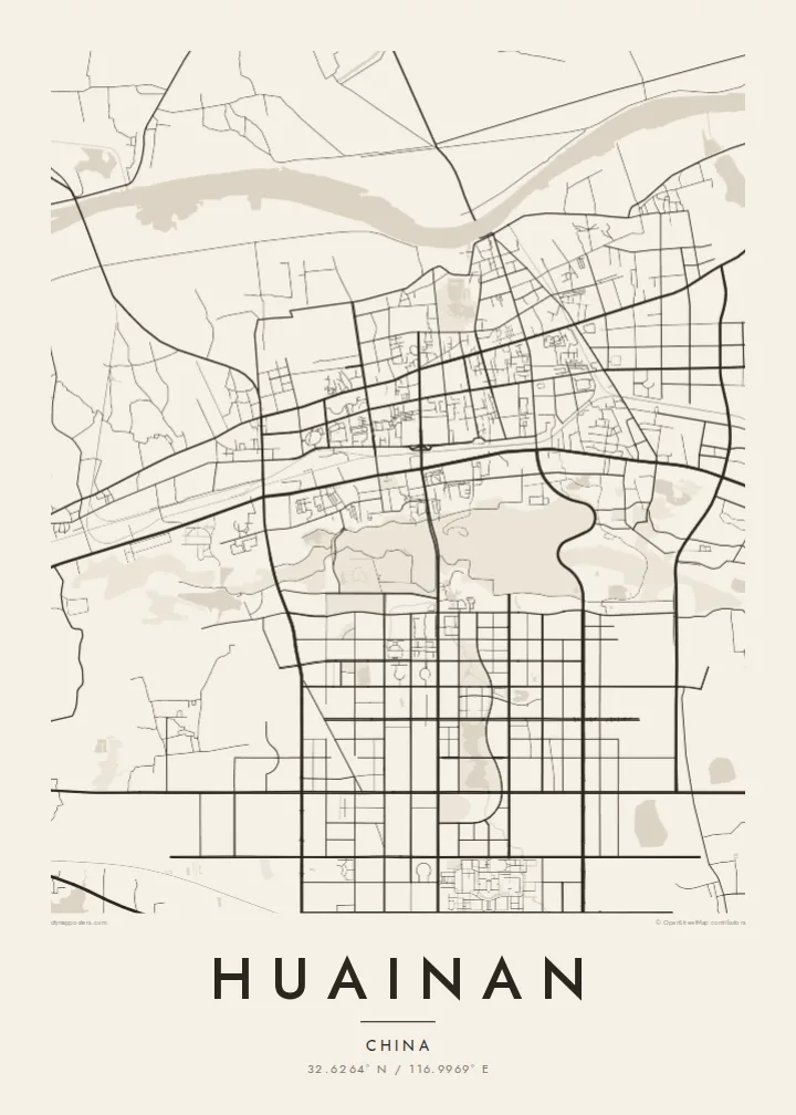
Huainan grew in the twentieth century as a coal-mining city in central Anhui, and its map reflects that origin. It did not spread from a single old centre. Instead it developed around separate mining areas along the southern bank of the Huai River, so its districts stretch out in a long east–west line with open land and water between them.
The Huai River is the clearest line on the map, a wide, curving waterway that marks the traditional division between northern and southern China. Mining subsidence has created lakes and wetlands in several parts of the area. Some have been turned into parks, adding irregular open shapes to the street pattern.
The city's name is linked to Liu An, Prince of Huainan in the Han dynasty and compiler of the Huainanzi, and tradition credits the region with the invention of tofu. Nearby Bagong Mountain is associated with the Battle of the Fei River. A Huainan map poster shows a city defined by its river and its industry.
The river runs along the northern edge of the city, broad and slowly curving. Bridges and embankments mark where the urban area meets the water.
Separate urban districts line up from east to west, joined by long main roads. The map's elongated outline comes from mining history rather than a planned centre.
Lakes that formed over old mine workings appear as irregular open areas among the streets. Some are now landscaped, a distinctive feature of coal cities on the plain.
Fè l pou ou
Ajoute yon dat, yon non oswa pwòp fraz pa w, chanje estil, gwosè oswa oryantasyon.
Apèsi gratis la se nan rezolisyon ba avèk yon watèrmak. Enpresyon ak fichye HD yo jenere nan 300 DPI, jiska 7,200 × 10,800 px, san watèrmak.
Poukisa Huainan
Huainan is hung by people who grew up with its mines, its river and its tofu dishes. For families who have lived there for generations, the map records a place that has changed a great deal and keeps changing.
Choose a title and subtitle, and keep or edit the coordinates line. Classic black & white, Noir, Paper, Blueprint and Sand are all available. The $9 digital files come in six sizes, and a free watermarked preview lets you check the framing first.
Kòmande afich Huainan a| Gwosè enpresyon | Rezolisyon | Fichye |
|---|---|---|
| 30 × 40 cm11.8 × 15.7″ | 3,543 × 4,724 px | PNG · PDF |
| 29.7 × 42 cm (A3)11.7 × 16.5″ | 3,508 × 4,961 px | PNG · PDF |
| 42 × 59.4 cm (A2)16.5 × 23.4″ | 4,961 × 7,016 px | PNG · PDF |
| 45.7 × 61 cm18 × 24″ | 5,400 × 7,200 px | PNG · PDF |
| 50 × 70 cm19.7 × 27.6″ | 5,906 × 8,268 px | PNG · PDF |
| 61 × 91.4 cm24 × 36″ | 7,200 × 10,800 px | PNG · PDF |
Pou konpare, apèsi gratis la gen 900 px lajè, li gen filigràn epi li fèt pou ekran. Fichye HD yo gen jiska 8 fwa plis rezolisyon nan chak direksyon epi yo enprime pwòp nan gwosè postè konplè.
Chwazi yon style anlè paj la, epi chwazi Afich Enprime — yon gwosè epi, si w vle, yon kad — oswa Fichye Dijital HD. Peman an fèt nan yon sèl etap, epi paj kòmand ou a mete ajou kou peman an konfime.
Li enprime sou papye mat premium 200 gsm nan youn nan sis gwosè, soti nan 30 × 40 cm rive nan 24 × 36″. Afich enprime yo kòmanse nan $39, livrezon enkli.
Wi. Chwazi yon kad an bwa solid nan koulè nwa, blan, chenn natirèl oswa bwa fonse. Li vin ak yon vit ki pa kase epi li pare pou pandye. Afich ankadre yo kòmanse nan $99, livrezon enkli.
Livrezon gratis nan plis pase 60 peyi. Chak afich enprime pa patnè enprimeri ki pi pre w la nan plis pase 30 peyi, e anjeneral li rive nan 3 a 7 jou ouvrab. Ou ka suiv estati a ak swivi kolis la nan Kòmand mwen yo. Kèk peyi pran 2 a 5 semèn, e kote nou poko livre, sit la di w sa anvan w peye.
Voye nou yon foto nan 14 jou apre livrezon an epi nou ap reenprime li gratis oswa remèt ou lajan w.
Wi. Nan editè a sou paj sa a, chanje tit la, soutit la ak liy kowòdone yo pou nenpòt sa w vle, epi chwazi yon style ak yon gwosè. Kòmand enprime, ankadre ak dijital yo tout itilize egzakteman desen w lan.
Pou $9 ou jwenn fichye PNG 300 DPI ak PDF pare-pou-enprime nan tout sis gwosè yo, san watèrmak, pou enprime kote w vle. Pa sèten toujou? Telechaje yon apèsi gratis ak watèrmak anvan.
