Central crossroads
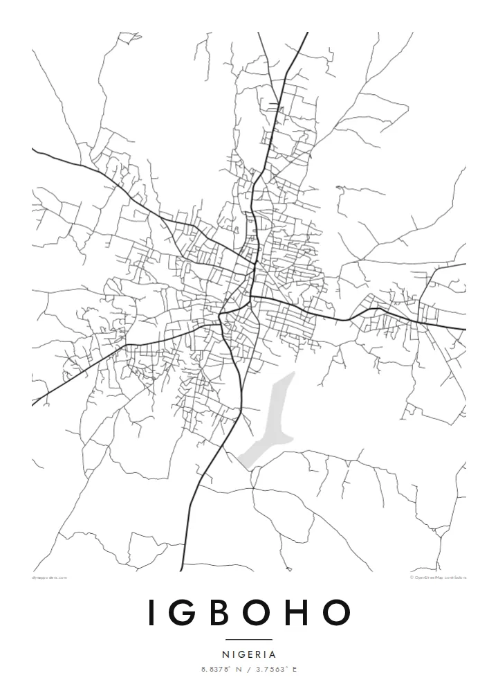
The main roads into town converge near the older core. This junction is the visual anchor of the map, and the rest of Igboho grows out from it in every direction.
Postè kat minimalis · Nigeria
8.8378° N / 3.7563° E
A savanna town of red-earth roads and scattered compounds, its streets radiating loosely across the open Oke-Ogun plains.


Yon vil, senk atmosfè
Peze yon style pou wè li sou mi a. Chak style koute menm pri — enprime, ankadre oswa kòm fichye HD.
 Piksèl reyèl · fichye enpresyon 24 × 36″
Byen klè pou enprime
Sa a se yon zoom 100% sou vrè fichye enpresyon an. Chak afich — enprime, ankadre oswa telechaje — jenere sou sèvè nou yo nan 300 DPI, jiska 7,200 × 10,800 piksèl, konsa menm pi piti wout yo rete klè sou yon enpresyon 24 × 36″.
Sou mi a


Kat la
Igboho is in the Oke-Ogun area of northern Oyo State. Here the forest thins into open savanna, and the towns sit far apart along long, straight roads. From above, the town is a loose, organic spread rather than a planned grid. Main roads meet near the old centre, and around them clusters of compounds and smaller lanes fan out, gradually giving way to farmland and bush.
The town has a firm place in Yoruba history. When the Oyo kingdom was driven from its capital, Oyo-Ile, Igboho became the seat of the Alaafins for a period, and several of them are remembered as having been buried there. Today it is the headquarters of Oorelope Local Government Area, and it is a market and farming centre for the surrounding countryside.
An Igboho map poster shows a town that has grown outward from its crossroads. Seen from above, the roads cut clean diagonals across the plain, and the small streets between them form an irregular, hand-drawn texture. With so few large rivers or hills in the frame, the pattern of settlement itself becomes the subject, rendered in fine lines on open space.
The main roads into town converge near the older core. This junction is the visual anchor of the map, and the rest of Igboho grows out from it in every direction.
Between the main roads, short lanes and paths link family compounds in an irregular weave. It is a dense, organic texture that contrasts with the straight regional highways.
Beyond the built-up area the map opens into farmland and savanna. The surrounding space gives the town clear edges and a strong silhouette on the page.
Fè l pou ou
Ajoute yon dat, yon non oswa pwòp fraz pa w, chanje estil, gwosè oswa oryantasyon.
Apèsi gratis la se nan rezolisyon ba avèk yon watèrmak. Enpresyon ak fichye HD yo jenere nan 300 DPI, jiska 7,200 × 10,800 px, san watèrmak.
Poukisa Igboho
For people from Igboho, and for its many families living elsewhere in Nigeria and abroad, a map of the town is a direct link to home, to the compound, the market and the roads that lead back to them.
Personalise the title, subtitle and coordinates line with a family name, a quarter or a meaningful date, and pick one of five styles: Classic black and white, Noir, Paper, Blueprint or Sand. Sand suits the warm savanna setting.
Kòmande afich Igboho a| Gwosè enpresyon | Rezolisyon | Fichye |
|---|---|---|
| 30 × 40 cm (11.8 × 15.7″) | 3,543 × 4,724 px | PNG · PDF |
| 29.7 × 42 cm (A3, 11.7 × 16.5″) | 3,508 × 4,961 px | PNG · PDF |
| 42 × 59.4 cm (A2, 16.5 × 23.4″) | 4,961 × 7,016 px | PNG · PDF |
| 45.7 × 61 cm (18 × 24″) | 5,400 × 7,200 px | PNG · PDF |
| 50 × 70 cm (19.7 × 27.6″) | 5,906 × 8,268 px | PNG · PDF |
| 61 × 91.4 cm (24 × 36″) | 7,200 × 10,800 px | PNG · PDF |
Pou konpare, apèsi gratis la gen 900 px lajè, li gen filigràn epi li fèt pou ekran. Fichye HD yo gen jiska 8 fwa plis rezolisyon nan chak direksyon epi yo enprime pwòp nan gwosè postè konplè.
Chwazi yon style anlè paj la, epi chwazi Afich Enprime — yon gwosè epi, si w vle, yon kad — oswa Fichye Dijital HD. Peman an fèt nan yon sèl etap, epi paj kòmand ou a mete ajou kou peman an konfime.
Li enprime sou papye mat premium 200 gsm nan youn nan sis gwosè, soti nan 30 × 40 cm rive nan 24 × 36″. Afich enprime yo kòmanse nan {printFrom}, livrezon enkli.
Wi. Chwazi yon kad an bwa solid nan koulè nwa, blan, chenn natirèl oswa bwa fonse. Li vin ak yon vit ki pa kase epi li pare pou pandye. Afich ankadre yo kòmanse nan {framedFrom}, livrezon enkli.
Livrezon gratis toupatou nan mond lan. Chak afich enprime nan patnè enpresyon ki pi pre nan plis pase 30 peyi, e li rive jeneralman nan 3–7 jou ouvrab. Ou ka swiv estati ak suivi anba My Orders.
Voye nou yon foto nan 14 jou apre livrezon an epi nou ap reenprime li gratis oswa remèt ou lajan w.
Wi. Nan editè a sou paj sa a, chanje tit la, soutit la ak liy kowòdone yo pou nenpòt sa w vle, epi chwazi yon style ak yon gwosè. Kòmand enprime, ankadre ak dijital yo tout itilize egzakteman desen w lan.
Pou $9 ou jwenn fichye PNG 300 DPI ak PDF pare-pou-enprime nan tout sis gwosè yo, san watèrmak, pou enprime kote w vle. Pa sèten toujou? Telechaje yon apèsi gratis ak watèrmak anvan.
