Sebou meanders
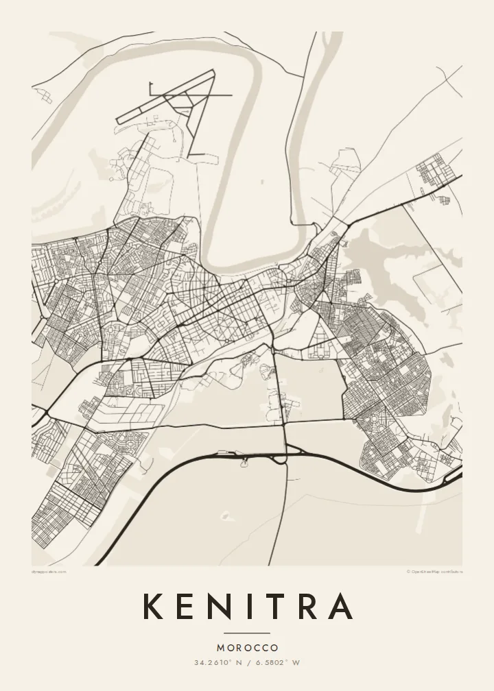
The river curves along the northern edge of the city in broad loops, with the port and quays along the bank marking the line between water and streets.
Postè kat minimalis · Morocco
34.2610° N / 6.5802° W
A river port on the looping Sebou near the Atlantic, with a planned French-era centre and a coastal lagoon to the south.




Yon vil, senk atmosfè
Peze yon style pou wè li sou mi a. Chak style koute menm pri — enprime, ankadre oswa kòm fichye HD.
 Piksèl reyèl · fichye enpresyon 24 × 36″
Byen klè pou enprime
Sa a se yon zoom 100% sou vrè fichye enpresyon an. Chak afich — enprime, ankadre oswa telechaje — jenere sou sèvè nou yo nan 300 DPI, jiska 7,200 × 10,800 piksèl, konsa menm pi piti wout yo rete klè sou yon enpresyon 24 × 36″.
Sou mi a


Kat la
Kenitra lies on the south bank of the Sebou River, a few kilometres upstream from its mouth on the Atlantic coast. The river loops in wide meanders past the city, and the port quays sit along its bank. On the map, the Sebou forms a strong curving boundary along the northern edge of the built area.
The centre was laid out by the French in the early twentieth century, and its regular pattern of avenues and roundabouts contrasts with newer districts spreading inland. Toward the coast, the resort of Mehdia sits at the river mouth beside an old kasbah, and to the south a lagoon and wetland reserve at Sidi Boughaba lie between the dunes and the forest.
The modern city began as a French military post and port in the early twentieth century, was known as Port Lyautey from 1932, and took back the name Kenitra after independence. It is now an industrial and university city in the Rabat-Salé-Kénitra region. A Kenitra map poster brings the river bends, the planned centre and the nearby coast together.
The river curves along the northern edge of the city in broad loops, with the port and quays along the bank marking the line between water and streets.
Straight avenues and radiating roads in the older centre reflect the French plan, forming a clear, orderly core within the looser newer districts.
At the mouth of the Sebou, the beach town of Mehdia and its hilltop kasbah face the Atlantic, with the Sidi Boughaba lagoon lying just to the south.
Fè l pou ou
Ajoute yon dat, yon non oswa pwòp fraz pa w, chanje estil, gwosè oswa oryantasyon.
Apèsi gratis la se nan rezolisyon ba avèk yon watèrmak. Enpresyon ak fichye HD yo jenere nan 300 DPI, jiska 7,200 × 10,800 px, san watèrmak.
Poukisa Kenitra
People from Kenitra often move to Rabat, Casablanca or abroad, and a map of the river city is a simple way to keep its streets in view. The combination of river loops and an ordered centre makes a composition that is both personal and graphic.
Set your own title, subtitle and coordinates line, and pick one of five styles; Sand suits the Atlantic coast, while Classic black & white stays crisp. The $9 download includes six sizes as PNG and PDF, and printed posters ship from partners in over 30 countries.
Kòmande afich Kenitra a| Gwosè enpresyon | Rezolisyon | Fichye |
|---|---|---|
| 30 × 40 cm (11.8 × 15.7″) | 3,543 × 4,724 px | PNG · PDF |
| 29.7 × 42 cm (A3, 11.7 × 16.5″) | 3,508 × 4,961 px | PNG · PDF |
| 42 × 59.4 cm (A2, 16.5 × 23.4″) | 4,961 × 7,016 px | PNG · PDF |
| 45.7 × 61 cm (18 × 24″) | 5,400 × 7,200 px | PNG · PDF |
| 50 × 70 cm (19.7 × 27.6″) | 5,906 × 8,268 px | PNG · PDF |
| 61 × 91.4 cm (24 × 36″) | 7,200 × 10,800 px | PNG · PDF |
Pou konpare, apèsi gratis la gen 900 px lajè, li gen filigràn epi li fèt pou ekran. Fichye HD yo gen jiska 8 fwa plis rezolisyon nan chak direksyon epi yo enprime pwòp nan gwosè postè konplè.
Chwazi yon style anlè paj la, epi chwazi Afich Enprime — yon gwosè epi, si w vle, yon kad — oswa Fichye Dijital HD. Peman an fèt nan yon sèl etap, epi paj kòmand ou a mete ajou kou peman an konfime.
Li enprime sou papye mat premium 200 gsm nan youn nan sis gwosè, soti nan 30 × 40 cm rive nan 24 × 36″. Afich enprime yo kòmanse nan $39, livrezon enkli.
Wi. Chwazi yon kad an bwa solid nan koulè nwa, blan, chenn natirèl oswa bwa fonse. Li vin ak yon vit ki pa kase epi li pare pou pandye. Afich ankadre yo kòmanse nan $99, livrezon enkli.
Livrezon an gratis nan tout mond lan. Se pi pwòch nan patnè enprimri nou yo nan plis pase 30 peyi ki enprime chak afich la, epi li anjeneral rive nan 3–7 jou ouvrab. Ou ka swiv estati ak swivi kolis la nan Kòmand mwen yo. Gen kèk peyi ki pran 2–5 semèn, e kote nou poko livre a, sit la di w anvan ou peye.
Voye nou yon foto nan 14 jou apre livrezon an epi nou ap reenprime li gratis oswa remèt ou lajan w.
Wi. Nan editè a sou paj sa a, chanje tit la, soutit la ak liy kowòdone yo pou nenpòt sa w vle, epi chwazi yon style ak yon gwosè. Kòmand enprime, ankadre ak dijital yo tout itilize egzakteman desen w lan.
Pou $9 ou jwenn fichye PNG 300 DPI ak PDF pare-pou-enprime nan tout sis gwosè yo, san watèrmak, pou enprime kote w vle. Pa sèten toujou? Telechaje yon apèsi gratis ak watèrmak anvan.
