Lake-strewn land
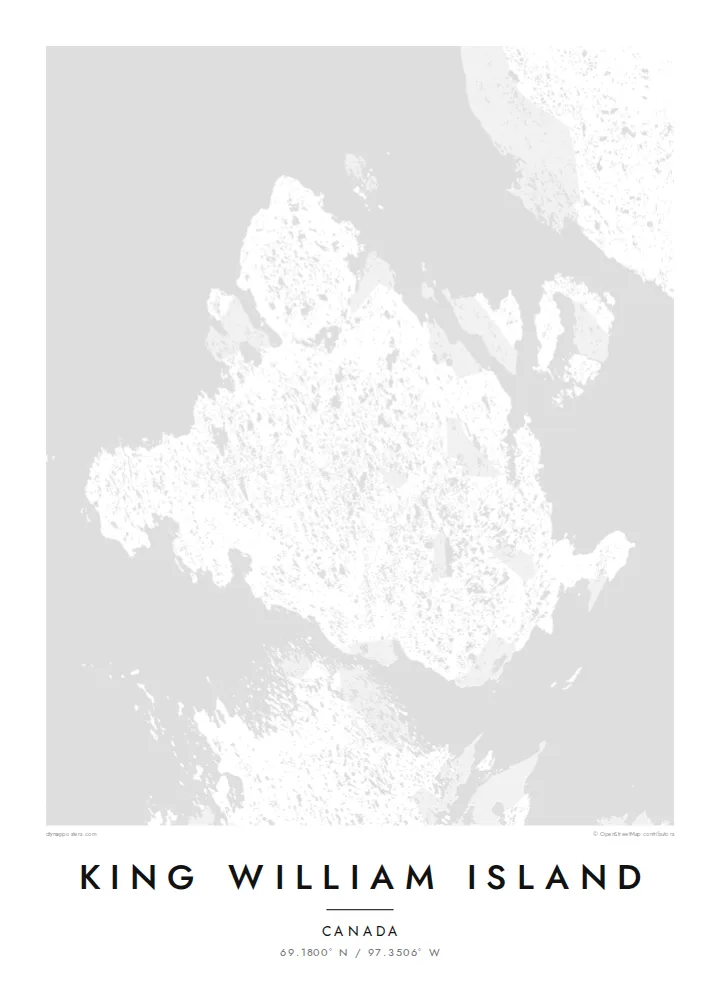
Thousands of small lakes cover the flat interior. They give the map a dense, dotted texture unlike most island outlines.
Postè kat minimalis · Canada
69.1800° N / 97.3506° W
A flat Arctic island scattered with lakes, in the channels where the Franklin expedition was lost


Yon vil, senk atmosfè
Peze yon style pou wè li sou mi a. Chak style koute menm pri — enprime, ankadre oswa kòm fichye HD.
 Piksèl reyèl · fichye enpresyon 24 × 36″
Byen klè pou enprime
Sa a se yon zoom 100% sou vrè fichye enpresyon an. Chak afich — enprime, ankadre oswa telechaje — jenere sou sèvè nou yo nan 300 DPI, jiska 7,200 × 10,800 piksèl, konsa menm pi piti wout yo rete klè sou yon enpresyon 24 × 36″.
Sou mi a


Kat la
King William Island lies in the Kitikmeot Region of Nunavut, in the Canadian Arctic. From above it is a broad, low island. The terrain is almost level, and the landscape is dotted with countless lakes and ponds left by glaciation, so the map looks finely speckled with water.
The only community is Gjoa Haven, on the southeastern coast. It takes its name from the Gjøa, the ship in which Roald Amundsen spent two winters in the harbour in the early 1900s while searching for the Northwest Passage. Inuit taught him skills that helped his expedition succeed.
The waters around the island are where Sir John Franklin's 1840s expedition was lost. The wrecks of HMS Erebus and HMS Terror were found nearby in 2014 and 2016. A King William Island map poster sets this history against a quiet pattern of lakes and shoreline.
Thousands of small lakes cover the flat interior. They give the map a dense, dotted texture unlike most island outlines.
The single settlement sits beside a sheltered harbour on the southeast coast, a small cluster of streets on an otherwise open island.
Narrow channels separate the island from the mainland and neighbouring islands. These are the passages at the heart of the Northwest Passage story.
Fè l pou ou
Ajoute yon dat, yon non oswa pwòp fraz pa w, chanje estil, gwosè oswa oryantasyon.
Apèsi gratis la se nan rezolisyon ba avèk yon watèrmak. Enpresyon ak fichye HD yo jenere nan 300 DPI, jiska 7,200 × 10,800 px, san watèrmak.
Poukisa King William Island
For people from Gjoa Haven, and for anyone who has followed the Franklin search or the Northwest Passage, this map carries real meaning. Its lake pattern is also striking as pure design.
Add your own title, subtitle and coordinates line, such as a family name, a year or a place. Choose Classic black & white, Noir, Paper, Blueprint or Sand.
Kòmande afich King William Island a| Gwosè enpresyon | Rezolisyon | Fichye |
|---|---|---|
| 30 × 40 cm11.8 × 15.7″ | 3,543 × 4,724 px | PNG · PDF |
| 29.7 × 42 cm (A3)11.7 × 16.5″ | 3,508 × 4,961 px | PNG · PDF |
| 42 × 59.4 cm (A2)16.5 × 23.4″ | 4,961 × 7,016 px | PNG · PDF |
| 45.7 × 61 cm18 × 24″ | 5,400 × 7,200 px | PNG · PDF |
| 50 × 70 cm19.7 × 27.6″ | 5,906 × 8,268 px | PNG · PDF |
| 61 × 91.4 cm24 × 36″ | 7,200 × 10,800 px | PNG · PDF |
Pou konpare, apèsi gratis la gen 900 px lajè, li gen filigràn epi li fèt pou ekran. Fichye HD yo gen jiska 8 fwa plis rezolisyon nan chak direksyon epi yo enprime pwòp nan gwosè postè konplè.
Chwazi yon style anlè paj la, epi chwazi Afich Enprime — yon gwosè epi, si w vle, yon kad — oswa Fichye Dijital HD. Peman an fèt nan yon sèl etap, epi paj kòmand ou a mete ajou kou peman an konfime.
Li enprime sou papye mat premium 200 gsm nan youn nan sis gwosè, soti nan 30 × 40 cm rive nan 24 × 36″. Afich enprime yo kòmanse nan $39, livrezon enkli.
Wi. Chwazi yon kad an bwa solid nan koulè nwa, blan, chenn natirèl oswa bwa fonse. Li vin ak yon vit ki pa kase epi li pare pou pandye. Afich ankadre yo kòmanse nan $99, livrezon enkli.
Livrezon gratis nan plis pase 60 peyi. Chak afich enprime pa patnè enprimeri ki pi pre w la nan plis pase 30 peyi, e anjeneral li rive nan 3 a 7 jou ouvrab. Ou ka suiv estati a ak swivi kolis la nan Kòmand mwen yo. Kèk peyi pran 2 a 5 semèn, e kote nou poko livre, sit la di w sa anvan w peye.
Voye nou yon foto nan 14 jou apre livrezon an epi nou ap reenprime li gratis oswa remèt ou lajan w.
Wi. Nan editè a sou paj sa a, chanje tit la, soutit la ak liy kowòdone yo pou nenpòt sa w vle, epi chwazi yon style ak yon gwosè. Kòmand enprime, ankadre ak dijital yo tout itilize egzakteman desen w lan.
Pou $9 ou jwenn fichye PNG 300 DPI ak PDF pare-pou-enprime nan tout sis gwosè yo, san watèrmak, pou enprime kote w vle. Pa sèten toujou? Telechaje yon apèsi gratis ak watèrmak anvan.
Toupre
