Doshisha campus
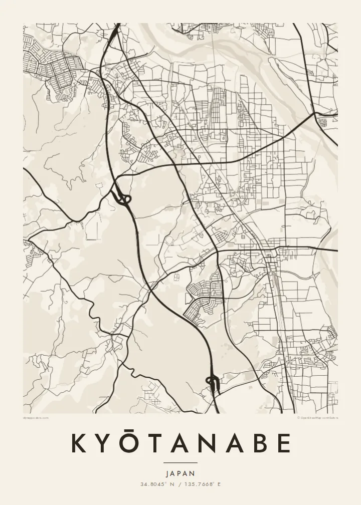
On the western hills, the university's Kyotanabe campus forms a large, clearly bounded area with its own internal roads and open spaces.
Postè kat minimalis · Japan
34.8045° N / 135.7668° E
A long north–south town between Kyoto and Nara, shaped by parallel rail lines, the Kizu River and a hillside university campus.




Yon vil, senk atmosfè
Peze yon style pou wè li sou mi a. Chak style koute menm pri — enprime, ankadre oswa kòm fichye HD.
 Piksèl reyèl · fichye enpresyon 24 × 36″
Byen klè pou enprime
Sa a se yon zoom 100% sou vrè fichye enpresyon an. Chak afich — enprime, ankadre oswa telechaje — jenere sou sèvè nou yo nan 300 DPI, jiska 7,200 × 10,800 piksèl, konsa menm pi piti wout yo rete klè sou yon enpresyon 24 × 36″.
Sou mi a


Kat la
Kyōtanabe stretches along the corridor between Kyoto and Nara, and its map is organised by lines running north to south. Two railways, the JR Gakkentoshi Line and the Kintetsu Kyoto Line, run through the town, and residential neighbourhoods have grown up around their stations. To the east, the Kizu River runs along the edge of the municipality, flanked by embankments and open ground.
To the west, the land rises into low hills, where the large Kyotanabe campus of Doshisha University occupies a broad area of paths and buildings. Between the hills and the river, housing estates, farmland and older village centres mix together, giving the map a varied texture. Tea is still grown in the surrounding area, part of the southern Kyoto tea-growing tradition.
The town is also home to Ikkyū-ji, the temple where the Zen monk Ikkyū spent his final years. A Kyōtanabe map poster captures the shape of a commuter town that still keeps traces of an older rural landscape, with rail, river and hills defining its outline more clearly than any single centre.
On the western hills, the university's Kyotanabe campus forms a large, clearly bounded area with its own internal roads and open spaces.
Along the eastern edge, the river and its embankments form a long, flowing line that sets the town's boundary against the neighbouring municipalities.
The temple associated with the monk Ikkyū sits in a quieter part of town, a small precinct set apart from the grid of newer neighbourhoods.
Fè l pou ou
Ajoute yon dat, yon non oswa pwòp fraz pa w, chanje estil, gwosè oswa oryantasyon.
Apèsi gratis la se nan rezolisyon ba avèk yon watèrmak. Enpresyon ak fichye HD yo jenere nan 300 DPI, jiska 7,200 × 10,800 px, san watèrmak.
Poukisa Kyōtanabe
For Doshisha students and graduates, Kyōtanabe is where years of study took place, and for residents it is a calm home between two historic cities. The map suits a graduation, a first apartment or a family house.
The title and subtitle can hold a name, a year or a station, and the coordinates line can be edited. Choose one of five styles; Classic black & white keeps the rail lines sharp, and Paper softens the whole plan.
Kòmande afich Kyōtanabe a| Gwosè enpresyon | Rezolisyon | Fichye |
|---|---|---|
| 30 × 40 cm11.8 × 15.7″ | 3,543 × 4,724 px | PNG · PDF |
| 29.7 × 42 cm (A3)11.7 × 16.5″ | 3,508 × 4,961 px | PNG · PDF |
| 42 × 59.4 cm (A2)16.5 × 23.4″ | 4,961 × 7,016 px | PNG · PDF |
| 45.7 × 61 cm18 × 24″ | 5,400 × 7,200 px | PNG · PDF |
| 50 × 70 cm19.7 × 27.6″ | 5,906 × 8,268 px | PNG · PDF |
| 61 × 91.4 cm24 × 36″ | 7,200 × 10,800 px | PNG · PDF |
Pou konpare, apèsi gratis la gen 900 px lajè, li gen filigràn epi li fèt pou ekran. Fichye HD yo gen jiska 8 fwa plis rezolisyon nan chak direksyon epi yo enprime pwòp nan gwosè postè konplè.
Chwazi yon style anlè paj la, epi chwazi Afich Enprime — yon gwosè epi, si w vle, yon kad — oswa Fichye Dijital HD. Peman an fèt nan yon sèl etap, epi paj kòmand ou a mete ajou kou peman an konfime.
Li enprime sou papye mat premium 200 gsm nan youn nan sis gwosè, soti nan 30 × 40 cm rive nan 24 × 36″. Afich enprime yo kòmanse nan $39, livrezon enkli.
Wi. Chwazi yon kad an bwa solid nan koulè nwa, blan, chenn natirèl oswa bwa fonse. Li vin ak yon vit ki pa kase epi li pare pou pandye. Afich ankadre yo kòmanse nan $99, livrezon enkli.
Livrezon gratis nan plis pase 60 peyi. Chak afich enprime pa patnè enprimeri ki pi pre w la nan plis pase 30 peyi, e anjeneral li rive nan 3 a 7 jou ouvrab. Ou ka suiv estati a ak swivi kolis la nan Kòmand mwen yo. Kèk peyi pran 2 a 5 semèn, e kote nou poko livre, sit la di w sa anvan w peye.
Voye nou yon foto nan 14 jou apre livrezon an epi nou ap reenprime li gratis oswa remèt ou lajan w.
Wi. Nan editè a sou paj sa a, chanje tit la, soutit la ak liy kowòdone yo pou nenpòt sa w vle, epi chwazi yon style ak yon gwosè. Kòmand enprime, ankadre ak dijital yo tout itilize egzakteman desen w lan.
Pou $9 ou jwenn fichye PNG 300 DPI ak PDF pare-pou-enprime nan tout sis gwosè yo, san watèrmak, pou enprime kote w vle. Pa sèten toujou? Telechaje yon apèsi gratis ak watèrmak anvan.
