Mountain backdrop
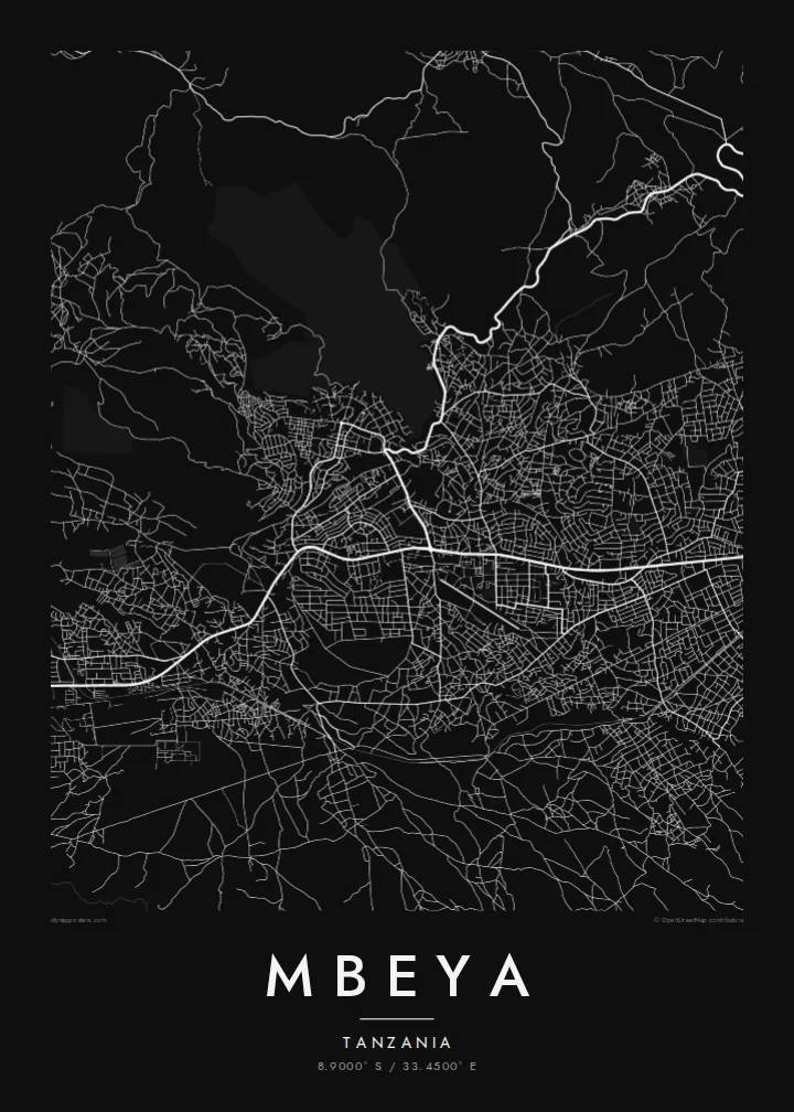
The Mbeya Range rises steeply beside the city. On the map its slopes appear as a broad open area that contrasts with the built-up valley floor.
Postè kat minimalis · Tanzania
8.9000° S / 33.4500° E
A highland city stretched along a valley floor, with steep mountain slopes rising close behind its northern edge.



Yon vil, senk atmosfè
Peze yon style pou wè li sou mi a. Chak style koute menm pri — enprime, ankadre oswa kòm fichye HD.
 Piksèl reyèl · fichye enpresyon 24 × 36″
Byen klè pou enprime
Sa a se yon zoom 100% sou vrè fichye enpresyon an. Chak afich — enprime, ankadre oswa telechaje — jenere sou sèvè nou yo nan 300 DPI, jiska 7,200 × 10,800 piksèl, konsa menm pi piti wout yo rete klè sou yon enpresyon 24 × 36″.
Sou mi a


Kat la
Mbeya lies high in the Southern Highlands of Tanzania, and the terrain sets the shape of the city. The built-up area extends along a valley at the foot of the Mbeya Range, so the plan is long rather than round, with roads following the lower slopes. On a map the mountain side appears largely empty, a clear boundary against the denser streets below.
The main highway and the TAZARA railway between Dar es Salaam and Zambia both pass through the area, and they form the strongest lines on the poster. Neighbourhoods branch off these corridors in irregular patterns, with smaller roads climbing the slopes and streams cutting down toward the valley. The result is a map with more movement than a flat grid.
Mbeya is the regional centre of the Southern Highlands and a crossroads on the way to the borders with Zambia and Malawi. The land around it is known for farming, helped by the cooler climate at altitude. A Mbeya map poster records a city defined by its setting, where the mountains are as much a part of the picture as the streets.
The Mbeya Range rises steeply beside the city. On the map its slopes appear as a broad open area that contrasts with the built-up valley floor.
The TanZam highway and the TAZARA railway cross the region in long lines. They organise the city and connect it with the coast in one direction and with Zambia in the other.
Because the city follows the valley, its districts are strung out in a line. Side roads climb toward the hills, and small watercourses run down between them.
Fè l pou ou
Ajoute yon dat, yon non oswa pwòp fraz pa w, chanje estil, gwosè oswa oryantasyon.
Apèsi gratis la se nan rezolisyon ba avèk yon watèrmak. Enpresyon ak fichye HD yo jenere nan 300 DPI, jiska 7,200 × 10,800 px, san watèrmak.
Poukisa Mbeya
For people from the Southern Highlands, and for those who worked or studied in Mbeya, the map is a direct reminder of the place: the long valley, the mountains close by and the roads heading out toward the border.
Every poster can carry your own title, a subtitle such as a date or a family name, and a coordinates line. Pick one of five styles and check the free watermarked preview first. Then print the files yourself or order a finished poster on matte paper.
Kòmande afich Mbeya a| Gwosè enpresyon | Rezolisyon | Fichye |
|---|---|---|
| 30 × 40 cm (11.8 × 15.7″) | 3,543 × 4,724 px | PNG · PDF |
| 29.7 × 42 cm (A3, 11.7 × 16.5″) | 3,508 × 4,961 px | PNG · PDF |
| 42 × 59.4 cm (A2, 16.5 × 23.4″) | 4,961 × 7,016 px | PNG · PDF |
| 45.7 × 61 cm (18 × 24″) | 5,400 × 7,200 px | PNG · PDF |
| 50 × 70 cm (19.7 × 27.6″) | 5,906 × 8,268 px | PNG · PDF |
| 61 × 91.4 cm (24 × 36″) | 7,200 × 10,800 px | PNG · PDF |
Pou konpare, apèsi gratis la gen 900 px lajè, li gen filigràn epi li fèt pou ekran. Fichye HD yo gen jiska 8 fwa plis rezolisyon nan chak direksyon epi yo enprime pwòp nan gwosè postè konplè.
Chwazi yon style anlè paj la, epi chwazi Afich Enprime — yon gwosè epi, si w vle, yon kad — oswa Fichye Dijital HD. Peman an fèt nan yon sèl etap, epi paj kòmand ou a mete ajou kou peman an konfime.
Li enprime sou papye mat premium 200 gsm nan youn nan sis gwosè, soti nan 30 × 40 cm rive nan 24 × 36″. Afich enprime yo kòmanse nan {printFrom}, livrezon enkli.
Wi. Chwazi yon kad an bwa solid nan koulè nwa, blan, chenn natirèl oswa bwa fonse. Li vin ak yon vit ki pa kase epi li pare pou pandye. Afich ankadre yo kòmanse nan {framedFrom}, livrezon enkli.
Livrezon an gratis nan tout mond lan. Se pi pwòch nan patnè enprimri nou yo nan plis pase 30 peyi ki enprime chak afich la, epi li anjeneral rive nan 3–7 jou ouvrab. Ou ka swiv estati ak swivi kolis la nan Kòmand mwen yo. Gen kèk peyi ki pran 2–5 semèn, e kote nou poko livre a, sit la di w anvan ou peye.
Voye nou yon foto nan 14 jou apre livrezon an epi nou ap reenprime li gratis oswa remèt ou lajan w.
Wi. Nan editè a sou paj sa a, chanje tit la, soutit la ak liy kowòdone yo pou nenpòt sa w vle, epi chwazi yon style ak yon gwosè. Kòmand enprime, ankadre ak dijital yo tout itilize egzakteman desen w lan.
Pou $9 ou jwenn fichye PNG 300 DPI ak PDF pare-pou-enprime nan tout sis gwosè yo, san watèrmak, pou enprime kote w vle. Pa sèten toujou? Telechaje yon apèsi gratis ak watèrmak anvan.
