Genbe River
One of the spring-fed streams through the centre, the Genbe River is lined with stepping stones and walkways and threads narrowly between the streets.
Postè kat minimalis · Japan
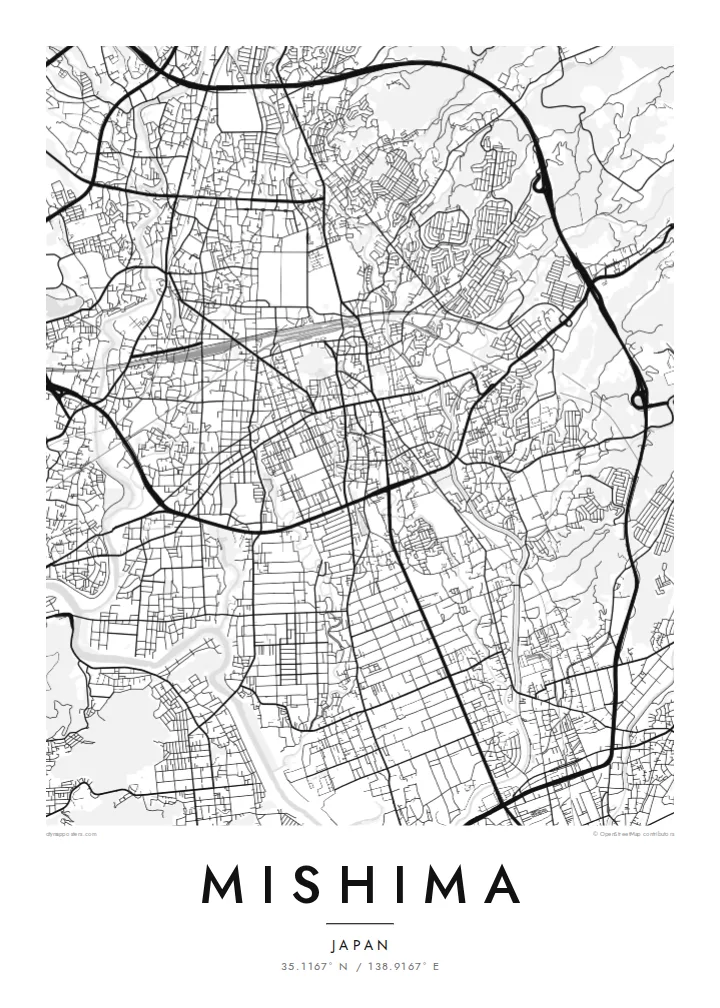
35.1167° N / 138.9167° E
A spring-fed city at the foot of Mount Fuji, where clear streams run between the streets and hill roads climb toward Hakone.


Yon vil, senk atmosfè
Peze yon style pou wè li sou mi a. Chak style koute menm pri — enprime, ankadre oswa kòm fichye HD.
 Piksèl reyèl · fichye enpresyon 24 × 36″
Byen klè pou enprime
Sa a se yon zoom 100% sou vrè fichye enpresyon an. Chak afich — enprime, ankadre oswa telechaje — jenere sou sèvè nou yo nan 300 DPI, jiska 7,200 × 10,800 piksèl, konsa menm pi piti wout yo rete klè sou yon enpresyon 24 × 36″.
Sou mi a


Kat la
Mishima lies in eastern Shizuoka Prefecture, between the lower slopes of Mount Fuji and the Hakone mountains. The city is known for its water. Snowmelt from Fuji filters through old lava beds and emerges as springs in the town centre, feeding clear streams that run between homes and along footpaths. On the map these waterways are thin, winding lines weaving through an otherwise compact street grid.
The centre grew as a post town on the old Tōkaidō road and around Mishima Taisha, an important Shinto shrine whose grounds still form a large green block in the city. Today the Tōkaidō Shinkansen stops here, and the station area anchors the southern part of downtown. A Mishima map poster shows old routes, shrine precincts and modern rail sharing the same small area.
To the east, roads climb into the Hakone hills, where the Mishima Skywalk, a long pedestrian suspension bridge, offers views of Fuji. To the south the city opens toward the plain around Numazu. In black and white, the fine streams and curving hill roads give the map an unusually delicate texture.
One of the spring-fed streams through the centre, the Genbe River is lined with stepping stones and walkways and threads narrowly between the streets.
The shrine grounds form a broad green block near the centre, a calm open space surrounded by the dense grid of the old post town.
East of the city, winding roads climb into the Hakone hills, and their curves contrast with the flatter, straighter streets of downtown.
Fè l pou ou
Ajoute yon dat, yon non oswa pwòp fraz pa w, chanje estil, gwosè oswa oryantasyon.
Apèsi gratis la se nan rezolisyon ba avèk yon watèrmak. Enpresyon ak fichye HD yo jenere nan 300 DPI, jiska 7,200 × 10,800 px, san watèrmak.
Poukisa Mishima
Mishima is a favourite stop for travellers heading to Fuji or Hakone and a home for families who value its clean streams and quiet streets. A map of the city holds that mix of water, shrine and mountain.
Add a title and a subtitle, perhaps the date of a trip, and select one of five styles. Blueprint and Noir both suit the water lines well. The $9 HD download includes six print sizes, each as a 300 DPI PNG and a print-ready PDF.
Kòmande afich Mishima a| Gwosè enpresyon | Rezolisyon | Fichye |
|---|---|---|
| 30 × 40 cm (11.8 × 15.7″) | 3,543 × 4,724 px | PNG · PDF |
| 29.7 × 42 cm (A3, 11.7 × 16.5″) | 3,508 × 4,961 px | PNG · PDF |
| 42 × 59.4 cm (A2, 16.5 × 23.4″) | 4,961 × 7,016 px | PNG · PDF |
| 45.7 × 61 cm (18 × 24″) | 5,400 × 7,200 px | PNG · PDF |
| 50 × 70 cm (19.7 × 27.6″) | 5,906 × 8,268 px | PNG · PDF |
| 61 × 91.4 cm (24 × 36″) | 7,200 × 10,800 px | PNG · PDF |
Pou konpare, apèsi gratis la gen 900 px lajè, li gen filigràn epi li fèt pou ekran. Fichye HD yo gen jiska 8 fwa plis rezolisyon nan chak direksyon epi yo enprime pwòp nan gwosè postè konplè.
Chwazi yon style anlè paj la, epi chwazi Afich Enprime — yon gwosè epi, si w vle, yon kad — oswa Fichye Dijital HD. Peman an fèt nan yon sèl etap, epi paj kòmand ou a mete ajou kou peman an konfime.
Li enprime sou papye mat premium 200 gsm nan youn nan sis gwosè, soti nan 30 × 40 cm rive nan 24 × 36″. Afich enprime yo kòmanse nan $39, livrezon enkli.
Wi. Chwazi yon kad an bwa solid nan koulè nwa, blan, chenn natirèl oswa bwa fonse. Li vin ak yon vit ki pa kase epi li pare pou pandye. Afich ankadre yo kòmanse nan $99, livrezon enkli.
Livrezon an gratis nan tout mond lan. Se pi pwòch nan patnè enprimri nou yo nan plis pase 30 peyi ki enprime chak afich la, epi li anjeneral rive nan 3–7 jou ouvrab. Ou ka swiv estati ak swivi kolis la nan Kòmand mwen yo. Gen kèk peyi ki pran 2–5 semèn, e kote nou poko livre a, sit la di w anvan ou peye.
Voye nou yon foto nan 14 jou apre livrezon an epi nou ap reenprime li gratis oswa remèt ou lajan w.
Wi. Nan editè a sou paj sa a, chanje tit la, soutit la ak liy kowòdone yo pou nenpòt sa w vle, epi chwazi yon style ak yon gwosè. Kòmand enprime, ankadre ak dijital yo tout itilize egzakteman desen w lan.
Pou $9 ou jwenn fichye PNG 300 DPI ak PDF pare-pou-enprime nan tout sis gwosè yo, san watèrmak, pou enprime kote w vle. Pa sèten toujou? Telechaje yon apèsi gratis ak watèrmak anvan.
