Highway lines
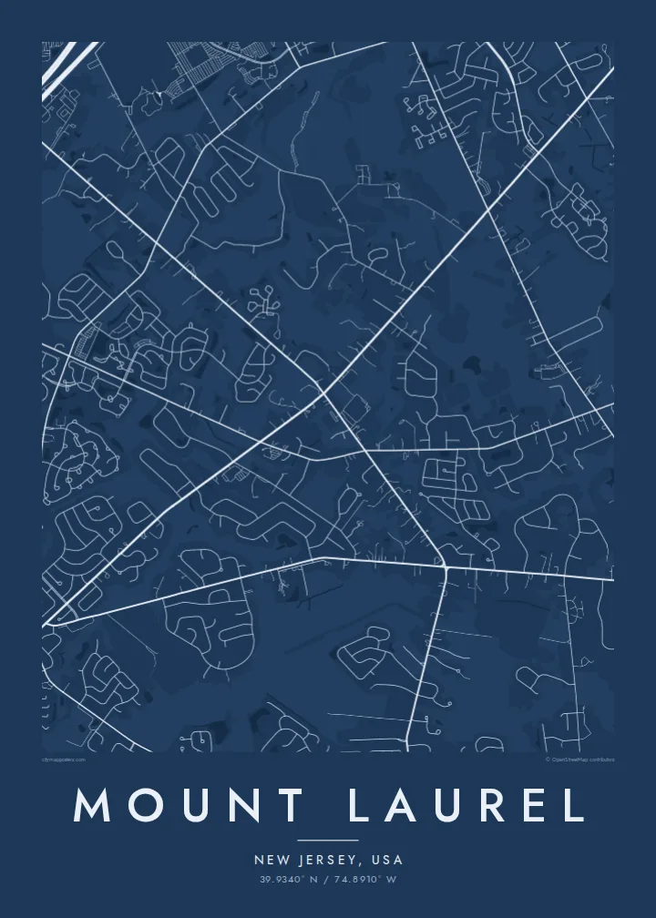
The New Jersey Turnpike and I-295 cut across the township, forming bold lines that divide its neighbourhoods into distinct sections.
Postè kat minimalis · United States
39.9340° N / 74.8910° W
A New Jersey suburban township of curving streets and cul-de-sacs, crossed by highways and edged by Rancocas Creek



Yon vil, senk atmosfè
Peze yon style pou wè li sou mi a. Chak style koute menm pri — enprime, ankadre oswa kòm fichye HD.
 Piksèl reyèl · fichye enpresyon 24 × 36″
Byen klè pou enprime
Sa a se yon zoom 100% sou vrè fichye enpresyon an. Chak afich — enprime, ankadre oswa telechaje — jenere sou sèvè nou yo nan 300 DPI, jiska 7,200 × 10,800 piksèl, konsa menm pi piti wout yo rete klè sou yon enpresyon 24 × 36″.
Sou mi a


Kat la
Mount Laurel is a township in Burlington County, New Jersey, east of Philadelphia. It is named after a small hill that rises in the area. From above, it reads as a classic American suburb: residential streets curling into loops and cul-de-sacs, commercial strips along main roads, and patches of woodland and parkland between them.
The New Jersey Turnpike and Interstate 295 both pass through the township, forming strong diagonal lines across the map. Rancocas Creek and its branches mark parts of the northern edge, adding natural curves. Office parks and shopping areas cluster near the highway interchanges.
Mount Laurel is known nationally for the Mount Laurel doctrine, a series of New Jersey Supreme Court decisions beginning in 1975 that required towns to provide their fair share of affordable housing. A Mount Laurel map poster shows the suburban pattern that was at the centre of that landmark legal debate.
The New Jersey Turnpike and I-295 cut across the township, forming bold lines that divide its neighbourhoods into distinct sections.
Residential streets loop and branch into dead ends, creating a fine, detailed pattern typical of late twentieth-century American suburbs.
The creek and its branches trace the township's northern side, adding winding water and wooded banks to the map.
Fè l pou ou
Ajoute yon dat, yon non oswa pwòp fraz pa w, chanje estil, gwosè oswa oryantasyon.
Apèsi gratis la se nan rezolisyon ba avèk yon watèrmak. Enpresyon ak fichye HD yo jenere nan 300 DPI, jiska 7,200 × 10,800 px, san watèrmak.
Poukisa Mount Laurel
Mount Laurel is home to many families and commuters, and a map of the township marks where they settled. It works well for a first house, a family room or a gift for someone who moved away.
Add your family name, a move-in date or neighbourhood as the subtitle, and edit the coordinates. Styles available are Classic black and white, Noir, Paper, Blueprint and Sand.
Kòmande afich Mount Laurel a| Gwosè enpresyon | Rezolisyon | Fichye |
|---|---|---|
| 30 × 40 cm11.8 × 15.7″ | 3,543 × 4,724 px | PNG · PDF |
| 29.7 × 42 cm (A3)11.7 × 16.5″ | 3,508 × 4,961 px | PNG · PDF |
| 42 × 59.4 cm (A2)16.5 × 23.4″ | 4,961 × 7,016 px | PNG · PDF |
| 45.7 × 61 cm18 × 24″ | 5,400 × 7,200 px | PNG · PDF |
| 50 × 70 cm19.7 × 27.6″ | 5,906 × 8,268 px | PNG · PDF |
| 61 × 91.4 cm24 × 36″ | 7,200 × 10,800 px | PNG · PDF |
Pou konpare, apèsi gratis la gen 900 px lajè, li gen filigràn epi li fèt pou ekran. Fichye HD yo gen jiska 8 fwa plis rezolisyon nan chak direksyon epi yo enprime pwòp nan gwosè postè konplè.
Chwazi yon style anlè paj la, epi chwazi Afich Enprime — yon gwosè epi, si w vle, yon kad — oswa Fichye Dijital HD. Peman an fèt nan yon sèl etap, epi paj kòmand ou a mete ajou kou peman an konfime.
Li enprime sou papye mat premium 200 gsm nan youn nan sis gwosè, soti nan 30 × 40 cm rive nan 24 × 36″. Afich enprime yo kòmanse nan $39, livrezon enkli.
Wi. Chwazi yon kad an bwa solid nan koulè nwa, blan, chenn natirèl oswa bwa fonse. Li vin ak yon vit ki pa kase epi li pare pou pandye. Afich ankadre yo kòmanse nan $99, livrezon enkli.
Livrezon gratis nan plis pase 60 peyi. Chak afich enprime pa patnè enprimeri ki pi pre w la nan plis pase 30 peyi, e anjeneral li rive nan 3 a 7 jou ouvrab. Ou ka suiv estati a ak swivi kolis la nan Kòmand mwen yo. Kèk peyi pran 2 a 5 semèn, e kote nou poko livre, sit la di w sa anvan w peye.
Voye nou yon foto nan 14 jou apre livrezon an epi nou ap reenprime li gratis oswa remèt ou lajan w.
Wi. Nan editè a sou paj sa a, chanje tit la, soutit la ak liy kowòdone yo pou nenpòt sa w vle, epi chwazi yon style ak yon gwosè. Kòmand enprime, ankadre ak dijital yo tout itilize egzakteman desen w lan.
Pou $9 ou jwenn fichye PNG 300 DPI ak PDF pare-pou-enprime nan tout sis gwosè yo, san watèrmak, pou enprime kote w vle. Pa sèten toujou? Telechaje yon apèsi gratis ak watèrmak anvan.
