Rosetta branch
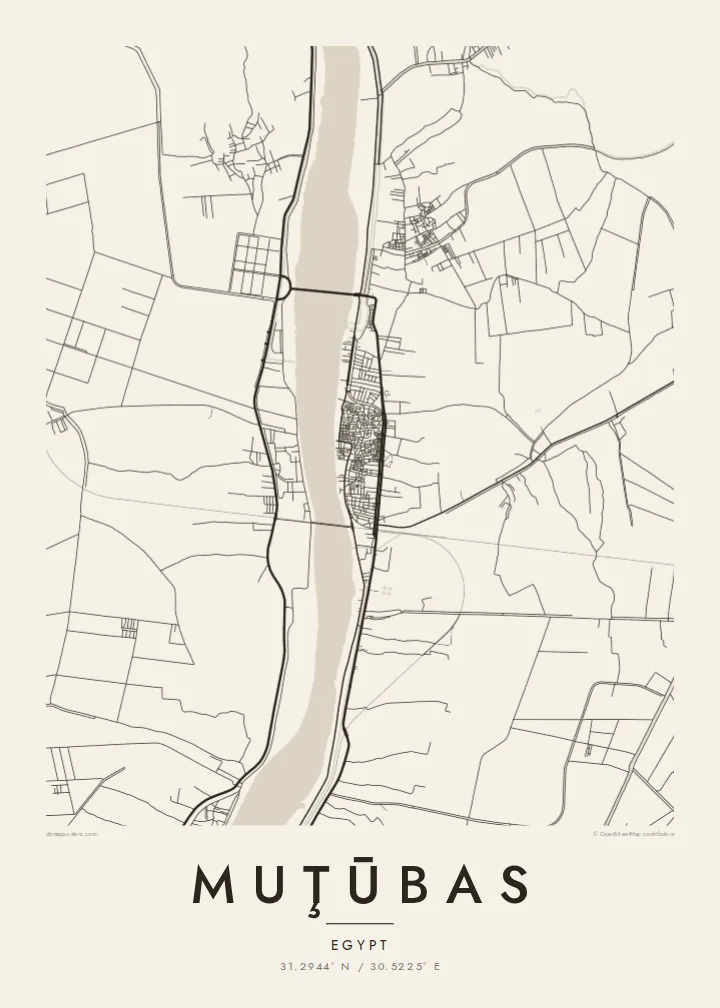
The western arm of the Nile runs past the town in a wide, smooth curve. It is the dominant feature of the composition and sets the town's orientation.
Postè kat minimalis · Egypt
31.2944° N / 30.5225° E
A delta town on the Rosetta branch of the Nile, surrounded by a fine grid of canals and fields




Yon vil, senk atmosfè
Peze yon style pou wè li sou mi a. Chak style koute menm pri — enprime, ankadre oswa kòm fichye HD.
 Piksèl reyèl · fichye enpresyon 24 × 36″
Byen klè pou enprime
Sa a se yon zoom 100% sou vrè fichye enpresyon an. Chak afich — enprime, ankadre oswa telechaje — jenere sou sèvè nou yo nan 300 DPI, jiska 7,200 × 10,800 piksèl, konsa menm pi piti wout yo rete klè sou yon enpresyon 24 × 36″.
Sou mi a


Kat la
Muţūbas sits in Kafr el-Sheikh Governorate on the eastern bank of the Rosetta branch, the western of the two arms the Nile splits into before it reaches the Mediterranean. The river is the strongest line on the map. It is a broad, gently curving band, and the town's compact centre presses up against it, with the densest streets closest to the water.
Away from the river, the land opens into the flat, intensively farmed delta. Irrigation canals and drainage channels cut the fields into long narrow strips, and small villages sit along the embankments. The town of Rosetta lies a short distance downstream near the sea, and the whole area is a lowland where water, silt and farming have shaped the land for thousands of years.
A Muţūbas map poster captures a landscape that looks almost woven when seen from above. The river's single sweep contrasts with hundreds of straight field edges, and the town is the one dense knot among them. For anyone with roots in this part of the northern delta, it shows home at the scale where the Nile's influence is most obvious.
The western arm of the Nile runs past the town in a wide, smooth curve. It is the dominant feature of the composition and sets the town's orientation.
Irrigation and drainage channels divide the surrounding fields into long parallel strips, creating dense linear texture typical of the northern Nile Delta.
The oldest and tightest streets cluster close to the riverbank, where the pattern of the built-up area is at its most intricate.
Fè l pou ou
Ajoute yon dat, yon non oswa pwòp fraz pa w, chanje estil, gwosè oswa oryantasyon.
Apèsi gratis la se nan rezolisyon ba avèk yon watèrmak. Enpresyon ak fichye HD yo jenere nan 300 DPI, jiska 7,200 × 10,800 px, san watèrmak.
Poukisa Muţūbas
This map is for people who left the delta for Cairo, Alexandria or further abroad and want the river of home on the wall. It also suits anyone drawn to the geometry of irrigated farmland, where every line has a practical purpose.
The title, subtitle and coordinates can all be personalised, for example with a family name in Arabic transliteration or a meaningful year. There are five styles: Classic black & white, Noir, Paper, Blueprint and Sand. A free 900 px watermarked preview lets you check the framing before buying.
Kòmande afich Muţūbas a| Gwosè enpresyon | Rezolisyon | Fichye |
|---|---|---|
| 30 × 40 cm (11.8 × 15.7″) | 3,543 × 4,724 px | PNG · PDF |
| 29.7 × 42 cm (A3, 11.7 × 16.5″) | 3,508 × 4,961 px | PNG · PDF |
| 42 × 59.4 cm (A2, 16.5 × 23.4″) | 4,961 × 7,016 px | PNG · PDF |
| 45.7 × 61 cm (18 × 24″) | 5,400 × 7,200 px | PNG · PDF |
| 50 × 70 cm (19.7 × 27.6″) | 5,906 × 8,268 px | PNG · PDF |
| 61 × 91.4 cm (24 × 36″) | 7,200 × 10,800 px | PNG · PDF |
Pou konpare, apèsi gratis la gen 900 px lajè, li gen filigràn epi li fèt pou ekran. Fichye HD yo gen jiska 8 fwa plis rezolisyon nan chak direksyon epi yo enprime pwòp nan gwosè postè konplè.
Chwazi yon style anlè paj la, epi chwazi Afich Enprime — yon gwosè epi, si w vle, yon kad — oswa Fichye Dijital HD. Peman an fèt nan yon sèl etap, epi paj kòmand ou a mete ajou kou peman an konfime.
Li enprime sou papye mat premium 200 gsm nan youn nan sis gwosè, soti nan 30 × 40 cm rive nan 24 × 36″. Afich enprime yo kòmanse nan {printFrom}, livrezon enkli.
Wi. Chwazi yon kad an bwa solid nan koulè nwa, blan, chenn natirèl oswa bwa fonse. Li vin ak yon vit ki pa kase epi li pare pou pandye. Afich ankadre yo kòmanse nan {framedFrom}, livrezon enkli.
Livrezon an gratis nan tout mond lan. Se pi pwòch nan patnè enprimri nou yo nan plis pase 30 peyi ki enprime chak afich la, epi li anjeneral rive nan 3–7 jou ouvrab. Ou ka swiv estati ak swivi kolis la nan Kòmand mwen yo. Gen kèk peyi ki pran 2–5 semèn, e kote nou poko livre a, sit la di w anvan ou peye.
Voye nou yon foto nan 14 jou apre livrezon an epi nou ap reenprime li gratis oswa remèt ou lajan w.
Wi. Nan editè a sou paj sa a, chanje tit la, soutit la ak liy kowòdone yo pou nenpòt sa w vle, epi chwazi yon style ak yon gwosè. Kòmand enprime, ankadre ak dijital yo tout itilize egzakteman desen w lan.
Pou $9 ou jwenn fichye PNG 300 DPI ak PDF pare-pou-enprime nan tout sis gwosè yo, san watèrmak, pou enprime kote w vle. Pa sèten toujou? Telechaje yon apèsi gratis ak watèrmak anvan.
