Junction rail lines
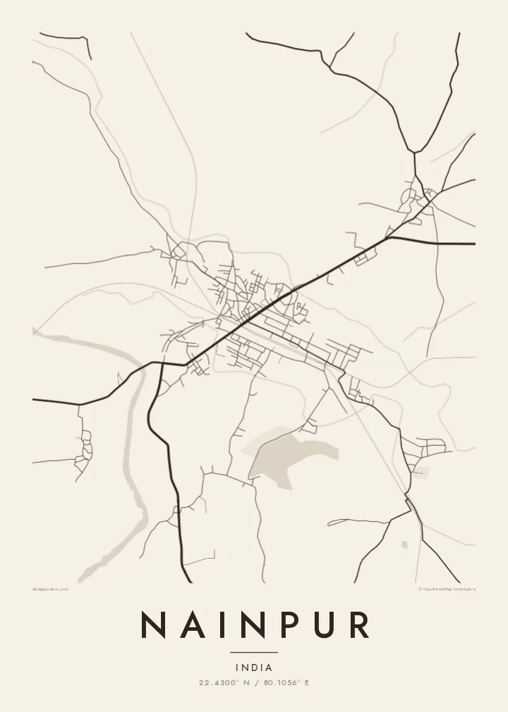
Several railway lines converge on the town, and their long, gently curving tracks and broad yard areas form the most prominent geometry on the map.
Postè kat minimalis · India
22.4300° N / 80.1056° E
A railway town in the Mandla district, where old junction tracks fan out across flat farmland and low forested ridges.




Yon vil, senk atmosfè
Peze yon style pou wè li sou mi a. Chak style koute menm pri — enprime, ankadre oswa kòm fichye HD.
 Piksèl reyèl · fichye enpresyon 24 × 36″
Byen klè pou enprime
Sa a se yon zoom 100% sou vrè fichye enpresyon an. Chak afich — enprime, ankadre oswa telechaje — jenere sou sèvè nou yo nan 300 DPI, jiska 7,200 × 10,800 piksèl, konsa menm pi piti wout yo rete klè sou yon enpresyon 24 × 36″.
Sou mi a


Kat la
Nainpur sits in the Mandla district of eastern Madhya Pradesh, in the upland country between the Narmada basin and the Satpura hills. On a map the town is a compact knot of streets bound tightly to its railway, with fields pressing in on every side. The lines of track do much of the drawing here, cutting long straight strokes through an otherwise loose, organic pattern of lanes.
For generations Nainpur was known as a junction on the Satpura narrow-gauge network, one of the larger such systems in India. That history still reads in the plan: yards, sidings and approach lines take up a large share of the built area, and the town's growth has followed the tracks rather than a planned grid. Roads leave in several directions toward surrounding villages and district towns.
A Nainpur map poster turns this working geography into a quiet composition. The heavy parallel lines of the railway set against a fine web of residential lanes, fading out into the blank of cultivated land, give the print a clear structure. It is a map shaped by transport rather than by a river or a coastline, and it looks it.
Several railway lines converge on the town, and their long, gently curving tracks and broad yard areas form the most prominent geometry on the map.
Close to the station, streets tighten into a dense, irregular cluster of lanes and markets, the darkest and most detailed part of the print.
Beyond the last houses the map thins quickly into field tracks and scattered villages, leaving generous white space around the town.
Fè l pou ou
Ajoute yon dat, yon non oswa pwòp fraz pa w, chanje estil, gwosè oswa oryantasyon.
Apèsi gratis la se nan rezolisyon ba avèk yon watèrmak. Enpresyon ak fichye HD yo jenere nan 300 DPI, jiska 7,200 × 10,800 px, san watèrmak.
Poukisa Nainpur
For anyone who grew up near the junction, worked on the railway or travelled through it, Nainpur is a place defined by arrivals and departures. A map on the wall keeps that sense of connection close, and it reads as a clean graphic even to guests who have never been there.
You can set your own title and subtitle, add a date that matters or adjust the coordinates line, then pick one of five styles: Classic black and white, Noir, Paper, Blueprint or Sand. Blueprint suits the railway lines particularly well.
Kòmande afich Nainpur a| Gwosè enpresyon | Rezolisyon | Fichye |
|---|---|---|
| 30 × 40 cm11.8 × 15.7″ | 3,543 × 4,724 px | PNG · PDF |
| 29.7 × 42 cm (A3)11.7 × 16.5″ | 3,508 × 4,961 px | PNG · PDF |
| 42 × 59.4 cm (A2)16.5 × 23.4″ | 4,961 × 7,016 px | PNG · PDF |
| 45.7 × 61 cm18 × 24″ | 5,400 × 7,200 px | PNG · PDF |
| 50 × 70 cm19.7 × 27.6″ | 5,906 × 8,268 px | PNG · PDF |
| 61 × 91.4 cm24 × 36″ | 7,200 × 10,800 px | PNG · PDF |
Pou konpare, apèsi gratis la gen 900 px lajè, li gen filigràn epi li fèt pou ekran. Fichye HD yo gen jiska 8 fwa plis rezolisyon nan chak direksyon epi yo enprime pwòp nan gwosè postè konplè.
Chwazi yon style anlè paj la, epi chwazi Afich Enprime — yon gwosè epi, si w vle, yon kad — oswa Fichye Dijital HD. Peman an fèt nan yon sèl etap, epi paj kòmand ou a mete ajou kou peman an konfime.
Li enprime sou papye mat premium 200 gsm nan youn nan sis gwosè, soti nan 30 × 40 cm rive nan 24 × 36″. Afich enprime yo kòmanse nan $39, livrezon enkli.
Wi. Chwazi yon kad an bwa solid nan koulè nwa, blan, chenn natirèl oswa bwa fonse. Li vin ak yon vit ki pa kase epi li pare pou pandye. Afich ankadre yo kòmanse nan $99, livrezon enkli.
Livrezon gratis nan plis pase 60 peyi. Chak afich enprime pa patnè enprimeri ki pi pre w la nan plis pase 30 peyi, e anjeneral li rive nan 3 a 7 jou ouvrab. Ou ka suiv estati a ak swivi kolis la nan Kòmand mwen yo. Kèk peyi pran 2 a 5 semèn, e kote nou poko livre, sit la di w sa anvan w peye.
Voye nou yon foto nan 14 jou apre livrezon an epi nou ap reenprime li gratis oswa remèt ou lajan w.
Wi. Nan editè a sou paj sa a, chanje tit la, soutit la ak liy kowòdone yo pou nenpòt sa w vle, epi chwazi yon style ak yon gwosè. Kòmand enprime, ankadre ak dijital yo tout itilize egzakteman desen w lan.
Pou $9 ou jwenn fichye PNG 300 DPI ak PDF pare-pou-enprime nan tout sis gwosè yo, san watèrmak, pou enprime kote w vle. Pa sèten toujou? Telechaje yon apèsi gratis ak watèrmak anvan.
