Nobbys breakwater
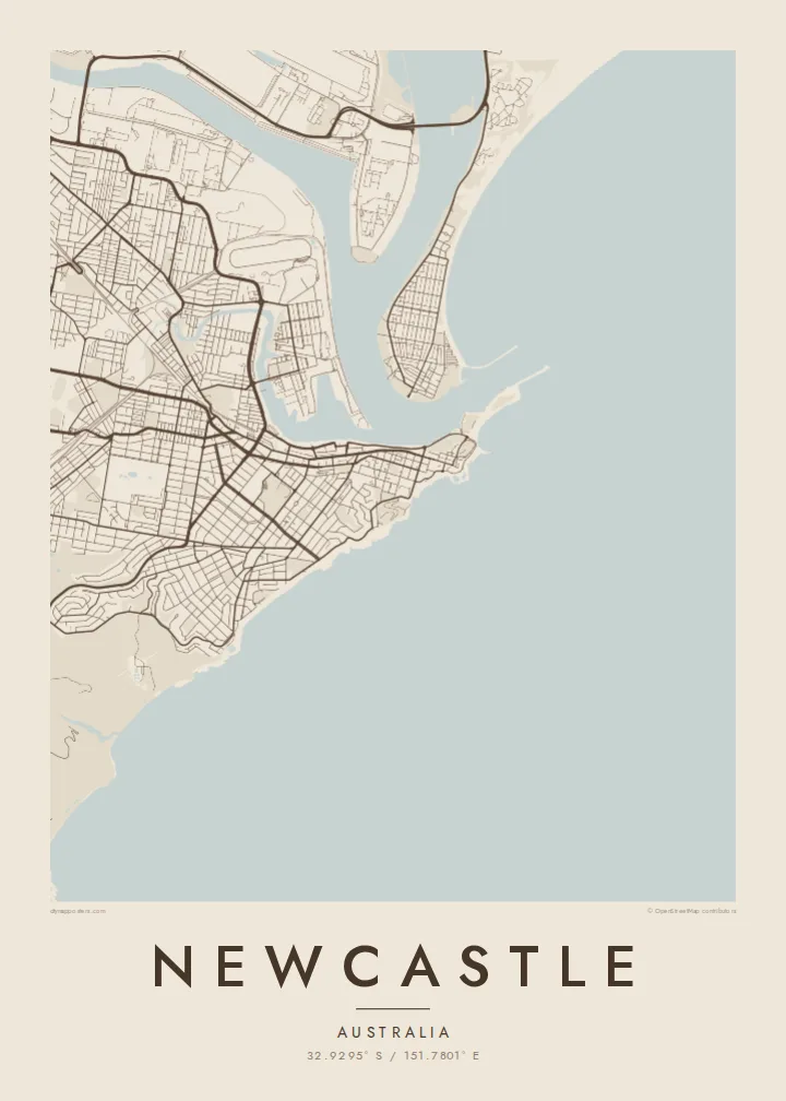
The breakwater runs from the city out to Nobbys Head at the harbour mouth. On the poster it is a slim, straight line that points into the empty ocean.
Postè kat minimalis · Australia
32.9295° S / 151.7801° E
A harbour city at the mouth of the Hunter River, with ocean beaches, headlands and a long breakwater pointing to sea


Yon vil, senk atmosfè
Peze yon style pou wè li sou mi a. Chak style koute menm pri — enprime, ankadre oswa kòm fichye HD.
 Piksèl reyèl · fichye enpresyon 24 × 36″
Byen klè pou enprime
Sa a se yon zoom 100% sou vrè fichye enpresyon an. Chak afich — enprime, ankadre oswa telechaje — jenere sou sèvè nou yo nan 300 DPI, jiska 7,200 × 10,800 piksèl, konsa menm pi piti wout yo rete klè sou yon enpresyon 24 × 36″.
Sou mi a


Kat la
Newcastle sits where the Hunter River meets the Pacific on the coast of New South Wales, about two hours north of Sydney. The city centre occupies a narrow tongue of land between the harbour and the ocean, its grid ending abruptly at the water on both sides, and the harbour entrance is guarded by the breakwater leading out to Nobbys Head and its lighthouse.
The port is one of the largest coal export harbours in the world, and its wharves, rail sidings and stockpiles spread across Kooragang Island and the riverbanks. Across the harbour, the Stockton peninsula runs north as a thin strip of sand. South of the centre, suburbs line up along a coast of surf beaches and rocky headlands toward Merewether.
At the foot of King Edward Park, the Bogey Hole, an ocean bath cut into the rock by convicts in the early nineteenth century, still fills with the tide. A Newcastle map poster brings these edges together: river, harbour, industry and surf, drawn as a single continuous coastline around a compact city grid.
The breakwater runs from the city out to Nobbys Head at the harbour mouth. On the poster it is a slim, straight line that points into the empty ocean.
The harbour and river channels wrap around Kooragang Island and the port facilities. Their branching shapes form the most complex part of the map, full of wharves and inlets.
South of the centre, beaches and headlands alternate along the Pacific shore. The coastline gives the print a clean edge and a gentle rhythm of curves and points.
Fè l pou ou
Ajoute yon dat, yon non oswa pwòp fraz pa w, chanje estil, gwosè oswa oryantasyon.
Apèsi gratis la se nan rezolisyon ba avèk yon watèrmak. Enpresyon ak fichye HD yo jenere nan 300 DPI, jiska 7,200 × 10,800 px, san watèrmak.
Poukisa Newcastle
Newcastle has a loyal crowd, from people who grew up surfing its beaches to those who came to study and never quite left. The map shows the working port and the coastline together, which is how locals know the city.
Set a custom title and subtitle, add the coordinates of your favourite break or your street, and choose from Classic black & white, Noir, Paper, Blueprint or Sand. Prints ship on matte paper, with an optional wooden frame.
Kòmande afich Newcastle a| Gwosè enpresyon | Rezolisyon | Fichye |
|---|---|---|
| 30 × 40 cm (11.8 × 15.7″) | 3,543 × 4,724 px | PNG · PDF |
| 29.7 × 42 cm (A3, 11.7 × 16.5″) | 3,508 × 4,961 px | PNG · PDF |
| 42 × 59.4 cm (A2, 16.5 × 23.4″) | 4,961 × 7,016 px | PNG · PDF |
| 45.7 × 61 cm (18 × 24″) | 5,400 × 7,200 px | PNG · PDF |
| 50 × 70 cm (19.7 × 27.6″) | 5,906 × 8,268 px | PNG · PDF |
| 61 × 91.4 cm (24 × 36″) | 7,200 × 10,800 px | PNG · PDF |
Pou konpare, apèsi gratis la gen 900 px lajè, li gen filigràn epi li fèt pou ekran. Fichye HD yo gen jiska 8 fwa plis rezolisyon nan chak direksyon epi yo enprime pwòp nan gwosè postè konplè.
Chwazi yon style anlè paj la, epi chwazi Afich Enprime — yon gwosè epi, si w vle, yon kad — oswa Fichye Dijital HD. Peman an fèt nan yon sèl etap, epi paj kòmand ou a mete ajou kou peman an konfime.
Li enprime sou papye mat premium 200 gsm nan youn nan sis gwosè, soti nan 30 × 40 cm rive nan 24 × 36″. Afich enprime yo kòmanse nan $39, livrezon enkli.
Wi. Chwazi yon kad an bwa solid nan koulè nwa, blan, chenn natirèl oswa bwa fonse. Li vin ak yon vit ki pa kase epi li pare pou pandye. Afich ankadre yo kòmanse nan $99, livrezon enkli.
Livrezon an gratis nan tout mond lan. Se pi pwòch nan patnè enprimri nou yo nan plis pase 30 peyi ki enprime chak afich la, epi li anjeneral rive nan 3–7 jou ouvrab. Ou ka swiv estati ak swivi kolis la nan Kòmand mwen yo. Gen kèk peyi ki pran 2–5 semèn, e kote nou poko livre a, sit la di w anvan ou peye.
Voye nou yon foto nan 14 jou apre livrezon an epi nou ap reenprime li gratis oswa remèt ou lajan w.
Wi. Nan editè a sou paj sa a, chanje tit la, soutit la ak liy kowòdone yo pou nenpòt sa w vle, epi chwazi yon style ak yon gwosè. Kòmand enprime, ankadre ak dijital yo tout itilize egzakteman desen w lan.
Pou $9 ou jwenn fichye PNG 300 DPI ak PDF pare-pou-enprime nan tout sis gwosè yo, san watèrmak, pou enprime kote w vle. Pa sèten toujou? Telechaje yon apèsi gratis ak watèrmak anvan.
