The braided Siang
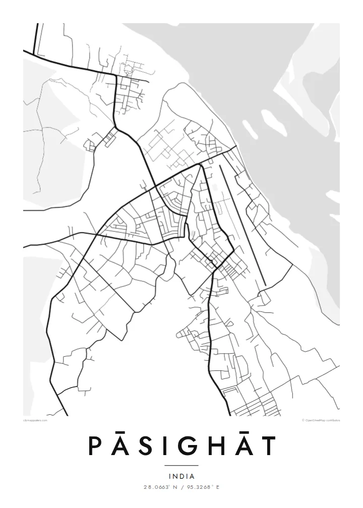
Below the town the river divides into many channels that separate and rejoin across a broad sandy bed, forming the most striking pattern on the map.
Postè kat minimalis · India
28.0663° N / 95.3268° E
A riverside town where the Siang leaves the Himalayan foothills and spreads into braided channels across the plains


Yon vil, senk atmosfè
Peze yon style pou wè li sou mi a. Chak style koute menm pri — enprime, ankadre oswa kòm fichye HD.
 Piksèl reyèl · fichye enpresyon 24 × 36″
Byen klè pou enprime
Sa a se yon zoom 100% sou vrè fichye enpresyon an. Chak afich — enprime, ankadre oswa telechaje — jenere sou sèvè nou yo nan 300 DPI, jiska 7,200 × 10,800 piksèl, konsa menm pi piti wout yo rete klè sou yon enpresyon 24 × 36″.
Sou mi a


Kat la
Pāsighāt is the headquarters of East Siang district and is often described as the oldest town in Arunachal Pradesh, established by the British in 1911. It stands at the foot of the hills, just where the Siang River emerges from its gorge onto the plains, before continuing into Assam as one of the main streams of the Brahmaputra.
That setting shapes the whole map. On one side, wooded ridges rise steeply; on the other, the river spreads into a wide, shifting bed of channels, sandbars and islands. The town fills the gently sloping ground between them, with a modest street network, an airfield and settlements of the Adi people, whose homeland this is.
A Pāsighāt map poster gives the river room to breathe. Framed wide, the braided Siang becomes the dominant element, a web of fine lines and pale sandbanks, while the town and the hills complete the scene. It is a fitting picture of a place often called the gateway to Arunachal.
Below the town the river divides into many channels that separate and rejoin across a broad sandy bed, forming the most striking pattern on the map.
Steep forested hills rise directly behind the town, and the change from flat plain to high ground shows clearly where the road network stops abruptly.
The compact town centre and the straight runway of the local airport sit on the plain beside the river, clear man-made lines within a natural landscape.
Fè l pou ou
Ajoute yon dat, yon non oswa pwòp fraz pa w, chanje estil, gwosè oswa oryantasyon.
Apèsi gratis la se nan rezolisyon ba avèk yon watèrmak. Enpresyon ak fichye HD yo jenere nan 300 DPI, jiska 7,200 × 10,800 px, san watèrmak.
Poukisa Pāsighāt
People from East Siang, those who served or studied in the region, and travellers who crossed the Siang here tend to remember the river above all. A map keeps that wide, restless water on the wall.
You can personalise the title and subtitle with a name or date, add the coordinates, and choose one of five styles: Classic black & white, Noir, Paper, Blueprint or Sand. Printed posters ship from partners in over 30 countries.
Kòmande afich Pāsighāt a| Gwosè enpresyon | Rezolisyon | Fichye |
|---|---|---|
| 30 × 40 cm (11.8 × 15.7″) | 3,543 × 4,724 px | PNG · PDF |
| 29.7 × 42 cm (A3, 11.7 × 16.5″) | 3,508 × 4,961 px | PNG · PDF |
| 42 × 59.4 cm (A2, 16.5 × 23.4″) | 4,961 × 7,016 px | PNG · PDF |
| 45.7 × 61 cm (18 × 24″) | 5,400 × 7,200 px | PNG · PDF |
| 50 × 70 cm (19.7 × 27.6″) | 5,906 × 8,268 px | PNG · PDF |
| 61 × 91.4 cm (24 × 36″) | 7,200 × 10,800 px | PNG · PDF |
Pou konpare, apèsi gratis la gen 900 px lajè, li gen filigràn epi li fèt pou ekran. Fichye HD yo gen jiska 8 fwa plis rezolisyon nan chak direksyon epi yo enprime pwòp nan gwosè postè konplè.
Chwazi yon style anlè paj la, epi chwazi Afich Enprime — yon gwosè epi, si w vle, yon kad — oswa Fichye Dijital HD. Peman an fèt nan yon sèl etap, epi paj kòmand ou a mete ajou kou peman an konfime.
Li enprime sou papye mat premium 200 gsm nan youn nan sis gwosè, soti nan 30 × 40 cm rive nan 24 × 36″. Afich enprime yo kòmanse nan $39, livrezon enkli.
Wi. Chwazi yon kad an bwa solid nan koulè nwa, blan, chenn natirèl oswa bwa fonse. Li vin ak yon vit ki pa kase epi li pare pou pandye. Afich ankadre yo kòmanse nan $99, livrezon enkli.
Livrezon an gratis nan tout mond lan. Se pi pwòch nan patnè enprimri nou yo nan plis pase 30 peyi ki enprime chak afich la, epi li anjeneral rive nan 3–7 jou ouvrab. Ou ka swiv estati ak swivi kolis la nan Kòmand mwen yo. Gen kèk peyi ki pran 2–5 semèn, e kote nou poko livre a, sit la di w anvan ou peye.
Voye nou yon foto nan 14 jou apre livrezon an epi nou ap reenprime li gratis oswa remèt ou lajan w.
Wi. Nan editè a sou paj sa a, chanje tit la, soutit la ak liy kowòdone yo pou nenpòt sa w vle, epi chwazi yon style ak yon gwosè. Kòmand enprime, ankadre ak dijital yo tout itilize egzakteman desen w lan.
Pou $9 ou jwenn fichye PNG 300 DPI ak PDF pare-pou-enprime nan tout sis gwosè yo, san watèrmak, pou enprime kote w vle. Pa sèten toujou? Telechaje yon apèsi gratis ak watèrmak anvan.
