Town grid
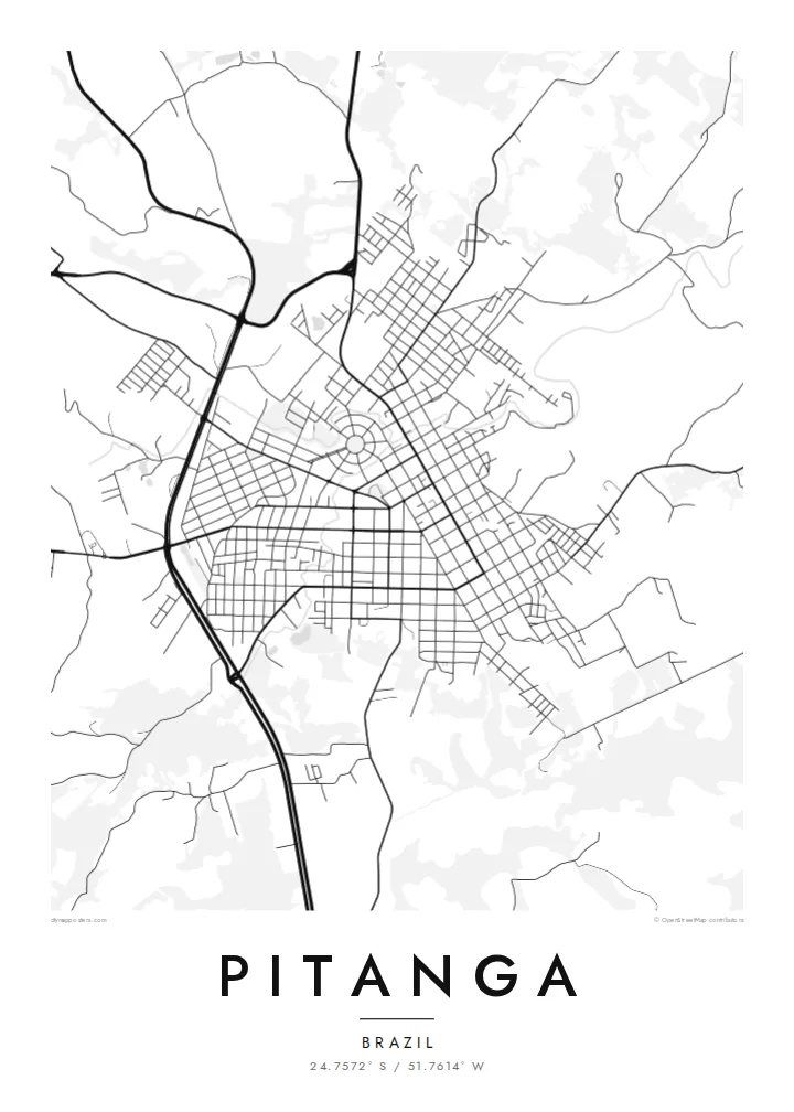
The central streets follow a mostly regular plan of rectangular blocks. On the poster they form a dense, tidy core that stands out from the countryside.
Postè kat minimalis · Brazil
24.7572° S / 51.7614° W
An interior Paraná town on the high plateau, its regular street grid surrounded by rolling farmland and roads leading to the countryside.


Yon vil, senk atmosfè
Peze yon style pou wè li sou mi a. Chak style koute menm pri — enprime, ankadre oswa kòm fichye HD.
 Piksèl reyèl · fichye enpresyon 24 × 36″
Byen klè pou enprime
Sa a se yon zoom 100% sou vrè fichye enpresyon an. Chak afich — enprime, ankadre oswa telechaje — jenere sou sèvè nou yo nan 300 DPI, jiska 7,200 × 10,800 piksèl, konsa menm pi piti wout yo rete klè sou yon enpresyon 24 × 36″.
Sou mi a


Kat la
Pitanga lies in central Paraná, on the rolling plateau that covers much of the state's interior. Like many towns in southern Brazil founded or expanded in the twentieth century, its centre is a fairly regular grid. On the map it appears as an orderly block of streets set among the more irregular lines of rural roads and field boundaries.
The surrounding area is agricultural, and that shows clearly from above. Roads leave town in several directions and branch into smaller tracks that divide the land into farms. Streams and patches of woodland cut through the fields and add soft, curving lines to the landscape. The town's edge is well defined, with a clear shift from urban blocks to open country.
The name is shared with the pitanga, the small ribbed red fruit native to Brazil, whose name comes from Tupi. A Pitanga map poster shows the town in its setting: a compact grid, the roads that link it to the plateau, and the patchwork of rural land around it.
The central streets follow a mostly regular plan of rectangular blocks. On the poster they form a dense, tidy core that stands out from the countryside.
Several roads leave town toward neighbouring communities and farms. They extend outward like spokes and link the grid to the wider plateau.
Small watercourses and wooded strips wind through the farmland around town. Their curved lines contrast with the straight streets of the centre.
Fè l pou ou
Ajoute yon dat, yon non oswa pwòp fraz pa w, chanje estil, gwosè oswa oryantasyon.
Apèsi gratis la se nan rezolisyon ba avèk yon watèrmak. Enpresyon ak fichye HD yo jenere nan 300 DPI, jiska 7,200 × 10,800 px, san watèrmak.
Poukisa Pitanga
People in Brazil's interior often feel deeply connected to their home town, even after moving to a state capital or abroad. A map of Pitanga keeps that connection visible, drawn simply enough to suit almost any room.
Change the title, subtitle and coordinates line, for example to add a family name or a year, and pick Classic black and white, Noir, Paper, Blueprint or Sand. Digital files are $9 and include 300 DPI PNGs and print-ready PDFs with no watermark.
Kòmande afich Pitanga a| Gwosè enpresyon | Rezolisyon | Fichye |
|---|---|---|
| 30 × 40 cm (11.8 × 15.7″) | 3,543 × 4,724 px | PNG · PDF |
| 29.7 × 42 cm (A3, 11.7 × 16.5″) | 3,508 × 4,961 px | PNG · PDF |
| 42 × 59.4 cm (A2, 16.5 × 23.4″) | 4,961 × 7,016 px | PNG · PDF |
| 45.7 × 61 cm (18 × 24″) | 5,400 × 7,200 px | PNG · PDF |
| 50 × 70 cm (19.7 × 27.6″) | 5,906 × 8,268 px | PNG · PDF |
| 61 × 91.4 cm (24 × 36″) | 7,200 × 10,800 px | PNG · PDF |
Pou konpare, apèsi gratis la gen 900 px lajè, li gen filigràn epi li fèt pou ekran. Fichye HD yo gen jiska 8 fwa plis rezolisyon nan chak direksyon epi yo enprime pwòp nan gwosè postè konplè.
Chwazi yon style anlè paj la, epi chwazi Afich Enprime — yon gwosè epi, si w vle, yon kad — oswa Fichye Dijital HD. Peman an fèt nan yon sèl etap, epi paj kòmand ou a mete ajou kou peman an konfime.
Li enprime sou papye mat premium 200 gsm nan youn nan sis gwosè, soti nan 30 × 40 cm rive nan 24 × 36″. Afich enprime yo kòmanse nan {printFrom}, livrezon enkli.
Wi. Chwazi yon kad an bwa solid nan koulè nwa, blan, chenn natirèl oswa bwa fonse. Li vin ak yon vit ki pa kase epi li pare pou pandye. Afich ankadre yo kòmanse nan {framedFrom}, livrezon enkli.
Livrezon an gratis nan tout mond lan. Se pi pwòch nan patnè enprimri nou yo nan plis pase 30 peyi ki enprime chak afich la, epi li anjeneral rive nan 3–7 jou ouvrab. Ou ka swiv estati ak swivi kolis la nan Kòmand mwen yo. Gen kèk peyi ki pran 2–5 semèn, e kote nou poko livre a, sit la di w anvan ou peye.
Voye nou yon foto nan 14 jou apre livrezon an epi nou ap reenprime li gratis oswa remèt ou lajan w.
Wi. Nan editè a sou paj sa a, chanje tit la, soutit la ak liy kowòdone yo pou nenpòt sa w vle, epi chwazi yon style ak yon gwosè. Kòmand enprime, ankadre ak dijital yo tout itilize egzakteman desen w lan.
Pou $9 ou jwenn fichye PNG 300 DPI ak PDF pare-pou-enprime nan tout sis gwosè yo, san watèrmak, pou enprime kote w vle. Pa sèten toujou? Telechaje yon apèsi gratis ak watèrmak anvan.
