Churni river
The Churni bends past the town in wide, unhurried curves. This single strong water line gives the composition its natural edge and contrasts with the straighter roads.
Postè kat minimalis · India
23.1762° N / 88.5667° E
A Nadia district railway town on the Churni river, its streets gathered along the tracks and the gentle bends of the water.



Yon vil, senk atmosfè
Peze yon style pou wè li sou mi a. Chak style koute menm pri — enprime, ankadre oswa kòm fichye HD.
 Piksèl reyèl · fichye enpresyon 24 × 36″
Byen klè pou enprime
Sa a se yon zoom 100% sou vrè fichye enpresyon an. Chak afich — enprime, ankadre oswa telechaje — jenere sou sèvè nou yo nan 300 DPI, jiska 7,200 × 10,800 piksèl, konsa menm pi piti wout yo rete klè sou yon enpresyon 24 × 36″.
Sou mi a


Kat la
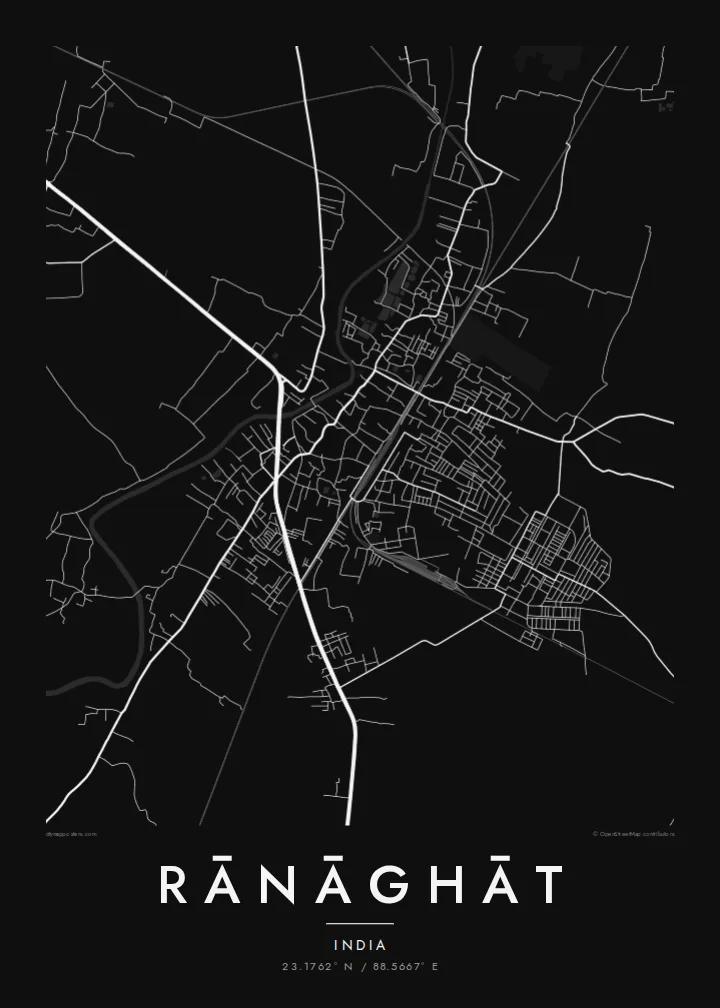
Rānāghāt lies in Nadia district in West Bengal, north of Kolkata on the flat, well-watered plain of the lower Ganges delta. The Churni river runs past the town in slow curves, and the land around it is laid out in fields, ponds and village clusters. On a map the town appears as a concentrated patch of streets set within that softer rural pattern.
The town is best known as a railway junction, where lines of the Sealdah suburban network branch toward different parts of the district and beyond. The tracks are among the clearest features of the plan: straight lines cutting through a street network that is otherwise irregular and closely built. Residential lanes fill the spaces between the railway, the main roads and the river.
A Rānāghāt map poster turns this into a clean, readable image: the river as a meandering band, the railway as a set of straight strokes, and the town's dense lanes filling the space between. It is a thoughtful piece for commuters who know the junction well, for families from Nadia, and for anyone attached to the everyday landscape of Bengal.
The Churni bends past the town in wide, unhurried curves. This single strong water line gives the composition its natural edge and contrasts with the straighter roads.
Rail lines meet and diverge at Rānāghāt. They are drawn as long straight strokes that cut across the street network and show clearly why the town grew where it did.
Around the town the map dissolves into fields, ponds and scattered settlements typical of the Bengal delta. This light, open texture frames the denser urban centre.
Fè l pou ou
Ajoute yon dat, yon non oswa pwòp fraz pa w, chanje estil, gwosè oswa oryantasyon.
Apèsi gratis la se nan rezolisyon ba avèk yon watèrmak. Enpresyon ak fichye HD yo jenere nan 300 DPI, jiska 7,200 × 10,800 px, san watèrmak.
Poukisa Rānāghāt
Many people know Rānāghāt through daily trains, family homes or school years, and a map of the town holds those routines in one image. Personalise the title and subtitle, perhaps with a family name or year, and keep the coordinates line as a precise marker.
Pick one of five styles, Classic black & white, Noir, Paper, Blueprint or Sand, and preview it free at 900 px with a watermark. The full $9 download gives six print sizes as 300 DPI PNG and print-ready PDF. You can also order a matte printed poster instead.
Kòmande afich Rānāghāt a| Gwosè enpresyon | Rezolisyon | Fichye |
|---|---|---|
| 30 × 40 cm (11.8 × 15.7″) | 3,543 × 4,724 px | PNG · PDF |
| 29.7 × 42 cm (A3, 11.7 × 16.5″) | 3,508 × 4,961 px | PNG · PDF |
| 42 × 59.4 cm (A2, 16.5 × 23.4″) | 4,961 × 7,016 px | PNG · PDF |
| 45.7 × 61 cm (18 × 24″) | 5,400 × 7,200 px | PNG · PDF |
| 50 × 70 cm (19.7 × 27.6″) | 5,906 × 8,268 px | PNG · PDF |
| 61 × 91.4 cm (24 × 36″) | 7,200 × 10,800 px | PNG · PDF |
Pou konpare, apèsi gratis la gen 900 px lajè, li gen filigràn epi li fèt pou ekran. Fichye HD yo gen jiska 8 fwa plis rezolisyon nan chak direksyon epi yo enprime pwòp nan gwosè postè konplè.
Chwazi yon style anlè paj la, epi chwazi Afich Enprime — yon gwosè epi, si w vle, yon kad — oswa Fichye Dijital HD. Peman an fèt nan yon sèl etap, epi paj kòmand ou a mete ajou kou peman an konfime.
Li enprime sou papye mat premium 200 gsm nan youn nan sis gwosè, soti nan 30 × 40 cm rive nan 24 × 36″. Afich enprime yo kòmanse nan {printFrom}, livrezon enkli.
Wi. Chwazi yon kad an bwa solid nan koulè nwa, blan, chenn natirèl oswa bwa fonse. Li vin ak yon vit ki pa kase epi li pare pou pandye. Afich ankadre yo kòmanse nan {framedFrom}, livrezon enkli.
Livrezon gratis toupatou nan mond lan. Chak afich enprime nan patnè enpresyon ki pi pre nan plis pase 30 peyi, e li rive jeneralman nan 3–7 jou ouvrab. Ou ka swiv estati ak suivi anba My Orders.
Voye nou yon foto nan 14 jou apre livrezon an epi nou ap reenprime li gratis oswa remèt ou lajan w.
Wi. Nan editè a sou paj sa a, chanje tit la, soutit la ak liy kowòdone yo pou nenpòt sa w vle, epi chwazi yon style ak yon gwosè. Kòmand enprime, ankadre ak dijital yo tout itilize egzakteman desen w lan.
Pou $9 ou jwenn fichye PNG 300 DPI ak PDF pare-pou-enprime nan tout sis gwosè yo, san watèrmak, pou enprime kote w vle. Pa sèten toujou? Telechaje yon apèsi gratis ak watèrmak anvan.
