Raja Bazaar
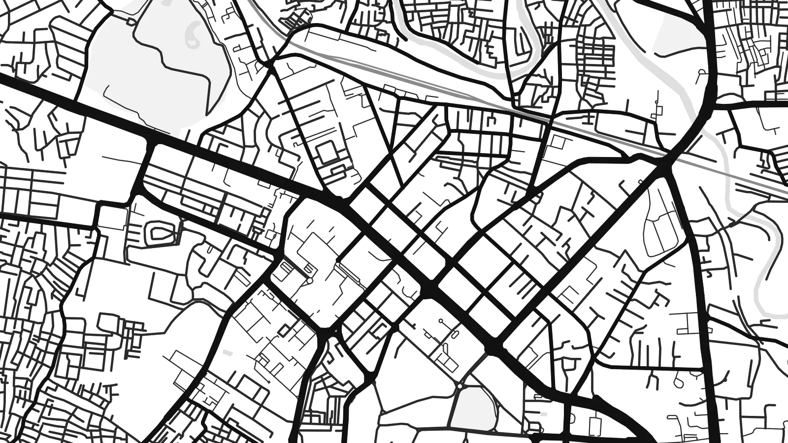
The historic commercial core is a tight weave of narrow streets and small plots. It is the densest texture on the map and contrasts sharply with the planned areas nearby.
Postè kat minimalis · Pakistan
33.5973° N / 73.0479° E
An old bazaar city and a planned cantonment side by side, with Islamabad's sectors beginning just beyond the northern edge.


Yon vil, senk atmosfè
Peze yon style pou wè li sou mi a. Chak style koute menm pri — enprime, ankadre oswa kòm fichye HD.
 Piksèl reyèl · fichye enpresyon 24 × 36″
Byen klè pou enprime
Sa a se yon zoom 100% sou vrè fichye enpresyon an. Chak afich — enprime, ankadre oswa telechaje — jenere sou sèvè nou yo nan 300 DPI, jiska 7,200 × 10,800 piksèl, konsa menm pi piti wout yo rete klè sou yon enpresyon 24 × 36″.
Sou mi a


Kat la
Rawalpindi grew as a trading town on the Grand Trunk Road and later became one of the largest military cantonments of British India. Both histories show from above. The old city around Raja Bazaar is a dense, irregular mesh of lanes. The cantonment to the south has wider roads, larger plots and noticeably more green space.
The Leh Nullah, a seasonal stream, winds through the city from north to south and has long defined its low-lying neighbourhoods. Murree Road runs north as the main spine. Since 2015 the elevated Metro Bus has followed it toward Islamabad, whose planned sectors begin only a few kilometres away. On the map the two cities form one continuous urban area.
Rawalpindi is also home to the headquarters of Pakistan's army and to a cricket stadium that has hosted Test matches. A Rawalpindi map poster can be framed tightly on the bazaars and Saddar. It can also be widened to take in the Soan River to the south and the Margalla Hills rising behind Islamabad.
The historic commercial core is a tight weave of narrow streets and small plots. It is the densest texture on the map and contrasts sharply with the planned areas nearby.
South of the old city, the cantonment has the broad, straight roads and spacious compounds of colonial military planning, with Saddar as its commercial centre.
The stream meanders through the city from the direction of Islamabad. Its line of open ground runs against the grain of the streets on either side.
Fè l pou ou
Ajoute yon dat, yon non oswa pwòp fraz pa w, chanje estil, gwosè oswa oryantasyon.
Apèsi gratis la se nan rezolisyon ba avèk yon watèrmak. Enpresyon ak fichye HD yo jenere nan 300 DPI, jiska 7,200 × 10,800 px, san watèrmak.
Poukisa Rawalpindi
Rawalpindi is a city of deep family roots and frequent departures, and many people who hang this map live far away from it. The mix of bazaar lanes and cantonment roads makes it easy to point out a childhood street or a family shop.
Change the title, write your own subtitle, and keep or edit the coordinates line. Five styles are available. The $9 download includes watermark-free 300 DPI PNG and PDF files in six sizes, and you can check a free preview first.
Kòmande afich Rawalpindi a| Gwosè enpresyon | Rezolisyon | Fichye |
|---|---|---|
| 30 × 40 cm11.8 × 15.7″ | 3,543 × 4,724 px | PNG · PDF |
| 29.7 × 42 cm (A3)11.7 × 16.5″ | 3,508 × 4,961 px | PNG · PDF |
| 42 × 59.4 cm (A2)16.5 × 23.4″ | 4,961 × 7,016 px | PNG · PDF |
| 45.7 × 61 cm18 × 24″ | 5,400 × 7,200 px | PNG · PDF |
| 50 × 70 cm19.7 × 27.6″ | 5,906 × 8,268 px | PNG · PDF |
| 61 × 91.4 cm24 × 36″ | 7,200 × 10,800 px | PNG · PDF |
Pou konpare, apèsi gratis la gen 900 px lajè, li gen filigràn epi li fèt pou ekran. Fichye HD yo gen jiska 8 fwa plis rezolisyon nan chak direksyon epi yo enprime pwòp nan gwosè postè konplè.
Chwazi yon style anlè paj la, epi chwazi Afich Enprime — yon gwosè epi, si w vle, yon kad — oswa Fichye Dijital HD. Peman an fèt nan yon sèl etap, epi paj kòmand ou a mete ajou kou peman an konfime.
Li enprime sou papye mat premium 200 gsm nan youn nan sis gwosè, soti nan 30 × 40 cm rive nan 24 × 36″. Afich enprime yo kòmanse nan $39, livrezon enkli.
Wi. Chwazi yon kad an bwa solid nan koulè nwa, blan, chenn natirèl oswa bwa fonse. Li vin ak yon vit ki pa kase epi li pare pou pandye. Afich ankadre yo kòmanse nan $99, livrezon enkli.
Livrezon gratis nan plis pase 60 peyi. Chak afich enprime pa patnè enprimeri ki pi pre w la nan plis pase 30 peyi, e anjeneral li rive nan 3 a 7 jou ouvrab. Ou ka suiv estati a ak swivi kolis la nan Kòmand mwen yo. Kèk peyi pran 2 a 5 semèn, e kote nou poko livre, sit la di w sa anvan w peye.
Voye nou yon foto nan 14 jou apre livrezon an epi nou ap reenprime li gratis oswa remèt ou lajan w.
Wi. Nan editè a sou paj sa a, chanje tit la, soutit la ak liy kowòdone yo pou nenpòt sa w vle, epi chwazi yon style ak yon gwosè. Kòmand enprime, ankadre ak dijital yo tout itilize egzakteman desen w lan.
Pou $9 ou jwenn fichye PNG 300 DPI ak PDF pare-pou-enprime nan tout sis gwosè yo, san watèrmak, pou enprime kote w vle. Pa sèten toujou? Telechaje yon apèsi gratis ak watèrmak anvan.
