Original town grid
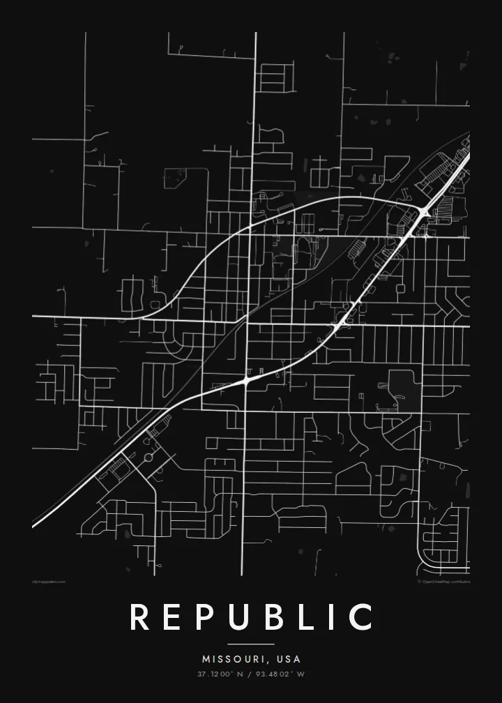
The historic centre follows a small grid of straight streets, a clear rectangular core that is still visible within the surrounding newer development.
Postè kat minimalis · United States
37.1200° N / 93.4802° W
A growing Ozarks suburb southwest of Springfield, with a small grid core surrounded by new subdivisions and farmland



Yon vil, senk atmosfè
Peze yon style pou wè li sou mi a. Chak style koute menm pri — enprime, ankadre oswa kòm fichye HD.
 Piksèl reyèl · fichye enpresyon 24 × 36″
Byen klè pou enprime
Sa a se yon zoom 100% sou vrè fichye enpresyon an. Chak afich — enprime, ankadre oswa telechaje — jenere sou sèvè nou yo nan 300 DPI, jiska 7,200 × 10,800 piksèl, konsa menm pi piti wout yo rete klè sou yon enpresyon 24 × 36″.
Sou mi a


Kat la
Republic sits in Greene County, Missouri, just southwest of Springfield, on the gently rolling ground of the Ozarks plateau. Its original town centre is a small grid of streets, and from above it forms a compact rectangle within a much larger area of later growth.
Over recent decades the city has expanded quickly, and the map shows that growth plainly: curving subdivision streets and cul-de-sacs spreading out from the older grid, with highway corridors connecting Republic to Springfield. Beyond the edges, farmland, woodlots and creek valleys fill the rest of the frame.
Just to the south lies Wilson's Creek National Battlefield, site of one of the first major Civil War battles west of the Mississippi in 1861. A Republic map poster that extends far enough includes its open fields, a quiet contrast to the suburban patterns to the north.
The historic centre follows a small grid of straight streets, a clear rectangular core that is still visible within the surrounding newer development.
Newer neighbourhoods spread outward in curving streets and cul-de-sacs, a pattern that shows how quickly the city has grown in recent decades.
South of the city, the national battlefield preserves open fields and wooded creek valleys, forming a broad, quiet area on the map.
Fè l pou ou
Ajoute yon dat, yon non oswa pwòp fraz pa w, chanje estil, gwosè oswa oryantasyon.
Apèsi gratis la se nan rezolisyon ba avèk yon watèrmak. Enpresyon ak fichye HD yo jenere nan 300 DPI, jiska 7,200 × 10,800 px, san watèrmak.
Poukisa Republic
Republic is the kind of place many families have moved to recently, and a map is a good way to mark that new start. It suits a first home, an entryway or a gift for someone who has just settled here.
Personalise the title, subtitle and coordinates line, adding a move-in date or street name if you wish, and choose Classic black & white, Noir, Paper, Blueprint or Sand. Download the files or order a printed poster.
Kòmande afich Republic a| Gwosè enpresyon | Rezolisyon | Fichye |
|---|---|---|
| 30 × 40 cm11.8 × 15.7″ | 3,543 × 4,724 px | PNG · PDF |
| 29.7 × 42 cm (A3)11.7 × 16.5″ | 3,508 × 4,961 px | PNG · PDF |
| 42 × 59.4 cm (A2)16.5 × 23.4″ | 4,961 × 7,016 px | PNG · PDF |
| 45.7 × 61 cm18 × 24″ | 5,400 × 7,200 px | PNG · PDF |
| 50 × 70 cm19.7 × 27.6″ | 5,906 × 8,268 px | PNG · PDF |
| 61 × 91.4 cm24 × 36″ | 7,200 × 10,800 px | PNG · PDF |
Pou konpare, apèsi gratis la gen 900 px lajè, li gen filigràn epi li fèt pou ekran. Fichye HD yo gen jiska 8 fwa plis rezolisyon nan chak direksyon epi yo enprime pwòp nan gwosè postè konplè.
Chwazi yon style anlè paj la, epi chwazi Afich Enprime — yon gwosè epi, si w vle, yon kad — oswa Fichye Dijital HD. Peman an fèt nan yon sèl etap, epi paj kòmand ou a mete ajou kou peman an konfime.
Li enprime sou papye mat premium 200 gsm nan youn nan sis gwosè, soti nan 30 × 40 cm rive nan 24 × 36″. Afich enprime yo kòmanse nan $39, livrezon enkli.
Wi. Chwazi yon kad an bwa solid nan koulè nwa, blan, chenn natirèl oswa bwa fonse. Li vin ak yon vit ki pa kase epi li pare pou pandye. Afich ankadre yo kòmanse nan $99, livrezon enkli.
Livrezon gratis nan plis pase 60 peyi. Chak afich enprime pa patnè enprimeri ki pi pre w la nan plis pase 30 peyi, e anjeneral li rive nan 3 a 7 jou ouvrab. Ou ka suiv estati a ak swivi kolis la nan Kòmand mwen yo. Kèk peyi pran 2 a 5 semèn, e kote nou poko livre, sit la di w sa anvan w peye.
Voye nou yon foto nan 14 jou apre livrezon an epi nou ap reenprime li gratis oswa remèt ou lajan w.
Wi. Nan editè a sou paj sa a, chanje tit la, soutit la ak liy kowòdone yo pou nenpòt sa w vle, epi chwazi yon style ak yon gwosè. Kòmand enprime, ankadre ak dijital yo tout itilize egzakteman desen w lan.
Pou $9 ou jwenn fichye PNG 300 DPI ak PDF pare-pou-enprime nan tout sis gwosè yo, san watèrmak, pou enprime kote w vle. Pa sèten toujou? Telechaje yon apèsi gratis ak watèrmak anvan.
