Historic core
The old town forms a tight knot of streets around the church. That core is still clearly readable within the later neighbourhoods around it.
Postè kat minimalis · Netherlands
51.5842° N / 4.3194° E
A West Brabant town rising from flat polders, with a harbour channel reaching toward the Volkerak



Yon vil, senk atmosfè
Peze yon style pou wè li sou mi a. Chak style koute menm pri — enprime, ankadre oswa kòm fichye HD.
 Piksèl reyèl · fichye enpresyon 24 × 36″
Byen klè pou enprime
Sa a se yon zoom 100% sou vrè fichye enpresyon an. Chak afich — enprime, ankadre oswa telechaje — jenere sou sèvè nou yo nan 300 DPI, jiska 7,200 × 10,800 piksèl, konsa menm pi piti wout yo rete klè sou yon enpresyon 24 × 36″.
Sou mi a


Kat la
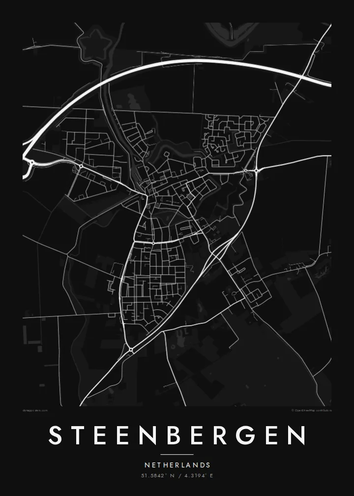
Steenbergen lies in the far west of North Brabant, close to the border with Zeeland. It was once a fortified town, and it has long been linked to the water. A harbour channel connects it to the Volkerak, and the surrounding land is reclaimed polder, flat and open, divided by dikes and drainage ditches.
The map shows a compact historic centre with streets that converge on the main church, which has a tall, recognisable tower. Around it, later neighbourhoods fill in the edges. Beyond the town, the polders are laid out in large rectangular fields, and dikes and roads follow the old lines of reclamation.
A Steenbergen map poster captures a typical Dutch arrangement: a dense core, an artificial waterway and a wide, ordered landscape around it. The dike lines and field grids give the surrounding space a quiet structure, so even the open countryside has plenty of detail in black and white.
The old town forms a tight knot of streets around the church. That core is still clearly readable within the later neighbourhoods around it.
A straight waterway leads from the town toward the Volkerak, recalling Steenbergen's long connection with shipping and the delta.
Around the town, reclaimed land is divided into large regular fields, with dikes and ditches tracing clean lines across the map.
Fè l pou ou
Ajoute yon dat, yon non oswa pwòp fraz pa w, chanje estil, gwosè oswa oryantasyon.
Apèsi gratis la se nan rezolisyon ba avèk yon watèrmak. Enpresyon ak fichye HD yo jenere nan 300 DPI, jiska 7,200 × 10,800 px, san watèrmak.
Poukisa Steenbergen
For residents, and for anyone with family in West Brabant, this map holds the familiar outline of town, channel and polder. It is understated enough to hang in a kitchen, hallway or study.
Personalise the title and subtitle, perhaps with your street or the year you moved in, and adjust the coordinates line. Choose from Classic black & white, Noir, Paper, Blueprint and Sand.
Kòmande afich Steenbergen a| Gwosè enpresyon | Rezolisyon | Fichye |
|---|---|---|
| 30 × 40 cm (11.8 × 15.7″) | 3,543 × 4,724 px | PNG · PDF |
| 29.7 × 42 cm (A3, 11.7 × 16.5″) | 3,508 × 4,961 px | PNG · PDF |
| 42 × 59.4 cm (A2, 16.5 × 23.4″) | 4,961 × 7,016 px | PNG · PDF |
| 45.7 × 61 cm (18 × 24″) | 5,400 × 7,200 px | PNG · PDF |
| 50 × 70 cm (19.7 × 27.6″) | 5,906 × 8,268 px | PNG · PDF |
| 61 × 91.4 cm (24 × 36″) | 7,200 × 10,800 px | PNG · PDF |
Pou konpare, apèsi gratis la gen 900 px lajè, li gen filigràn epi li fèt pou ekran. Fichye HD yo gen jiska 8 fwa plis rezolisyon nan chak direksyon epi yo enprime pwòp nan gwosè postè konplè.
Chwazi yon style anlè paj la, epi chwazi Afich Enprime — yon gwosè epi, si w vle, yon kad — oswa Fichye Dijital HD. Peman an fèt nan yon sèl etap, epi paj kòmand ou a mete ajou kou peman an konfime.
Li enprime sou papye mat premium 200 gsm nan youn nan sis gwosè, soti nan 30 × 40 cm rive nan 24 × 36″. Afich enprime yo kòmanse nan {printFrom}, livrezon enkli.
Wi. Chwazi yon kad an bwa solid nan koulè nwa, blan, chenn natirèl oswa bwa fonse. Li vin ak yon vit ki pa kase epi li pare pou pandye. Afich ankadre yo kòmanse nan {framedFrom}, livrezon enkli.
Livrezon gratis toupatou nan mond lan. Chak afich enprime nan patnè enpresyon ki pi pre nan plis pase 30 peyi, e li rive jeneralman nan 3–7 jou ouvrab. Ou ka swiv estati ak suivi anba My Orders.
Voye nou yon foto nan 14 jou apre livrezon an epi nou ap reenprime li gratis oswa remèt ou lajan w.
Wi. Nan editè a sou paj sa a, chanje tit la, soutit la ak liy kowòdone yo pou nenpòt sa w vle, epi chwazi yon style ak yon gwosè. Kòmand enprime, ankadre ak dijital yo tout itilize egzakteman desen w lan.
Pou $9 ou jwenn fichye PNG 300 DPI ak PDF pare-pou-enprime nan tout sis gwosè yo, san watèrmak, pou enprime kote w vle. Pa sèten toujou? Telechaje yon apèsi gratis ak watèrmak anvan.
