Makli ridge
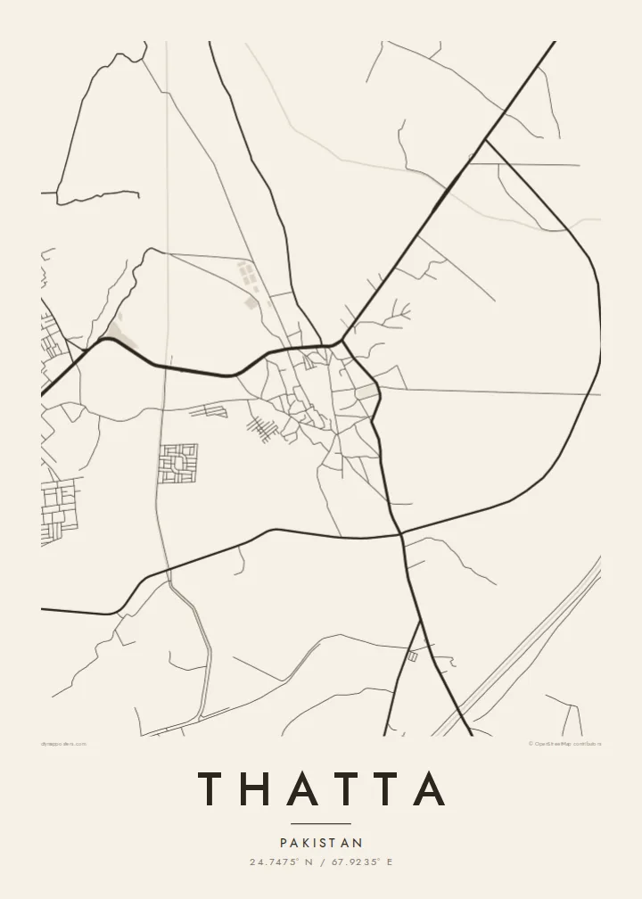
The necropolis stretches along a low ridge next to the town. On the map it appears as a long, sparsely lined area, very different in texture from the dense streets nearby.
Postè kat minimalis · Pakistan
24.7475° N / 67.9235° E
An old Sindhi town at the edge of the Indus delta, with the Makli necropolis spread along the ridge beside it




Yon vil, senk atmosfè
Peze yon style pou wè li sou mi a. Chak style koute menm pri — enprime, ankadre oswa kòm fichye HD.
 Piksèl reyèl · fichye enpresyon 24 × 36″
Byen klè pou enprime
Sa a se yon zoom 100% sou vrè fichye enpresyon an. Chak afich — enprime, ankadre oswa telechaje — jenere sou sèvè nou yo nan 300 DPI, jiska 7,200 × 10,800 piksèl, konsa menm pi piti wout yo rete klè sou yon enpresyon 24 × 36″.
Sou mi a


Kat la
Thatta lies in lower Sindh, east of the Indus as the river nears its delta. For several centuries it was a major city and a capital of the region. As the river shifted course, its commercial importance faded. Today it is a district town, but the traces of its earlier status remain unusually visible.
The best known is the Makli necropolis, a UNESCO World Heritage Site on a low ridge just outside the town. It is one of the largest funerary sites in the world, with tombs spread over several kilometres. Within Thatta itself stands the Shah Jahan Mosque, known for its tilework and many domes.
A Thatta map poster sets the town's irregular streets against the long, open strip of Makli and the flat delta country around it. The layout is not a grid. Lanes bend and meet at odd angles, which suggests centuries of gradual growth. The empty spaces on the map carry as much meaning as the built ones.
The necropolis stretches along a low ridge next to the town. On the map it appears as a long, sparsely lined area, very different in texture from the dense streets nearby.
Thatta's lanes follow no regular plan. They curve and branch in a way typical of old South Asian towns that grew slowly over many generations.
Flat land, canals and old river channels surround the town. They hint at the Indus and its shifting course, which shaped Thatta's rise and decline.
Fè l pou ou
Ajoute yon dat, yon non oswa pwòp fraz pa w, chanje estil, gwosè oswa oryantasyon.
Apèsi gratis la se nan rezolisyon ba avèk yon watèrmak. Enpresyon ak fichye HD yo jenere nan 300 DPI, jiska 7,200 × 10,800 px, san watèrmak.
Poukisa Thatta
Thatta appeals to people with family roots in Sindh and to anyone drawn to places where history is still visible in the ground plan. The map shows a town that was once a capital, drawn at the scale of its streets.
You can edit the title, subtitle and coordinates line, for example to add a name in Sindhi or Urdu. Then choose one of five styles; Sand and Paper suit the warm tones of the delta landscape.
Kòmande afich Thatta a| Gwosè enpresyon | Rezolisyon | Fichye |
|---|---|---|
| 30 × 40 cm (11.8 × 15.7″) | 3,543 × 4,724 px | PNG · PDF |
| 29.7 × 42 cm (A3, 11.7 × 16.5″) | 3,508 × 4,961 px | PNG · PDF |
| 42 × 59.4 cm (A2, 16.5 × 23.4″) | 4,961 × 7,016 px | PNG · PDF |
| 45.7 × 61 cm (18 × 24″) | 5,400 × 7,200 px | PNG · PDF |
| 50 × 70 cm (19.7 × 27.6″) | 5,906 × 8,268 px | PNG · PDF |
| 61 × 91.4 cm (24 × 36″) | 7,200 × 10,800 px | PNG · PDF |
Pou konpare, apèsi gratis la gen 900 px lajè, li gen filigràn epi li fèt pou ekran. Fichye HD yo gen jiska 8 fwa plis rezolisyon nan chak direksyon epi yo enprime pwòp nan gwosè postè konplè.
Chwazi yon style anlè paj la, epi chwazi Afich Enprime — yon gwosè epi, si w vle, yon kad — oswa Fichye Dijital HD. Peman an fèt nan yon sèl etap, epi paj kòmand ou a mete ajou kou peman an konfime.
Li enprime sou papye mat premium 200 gsm nan youn nan sis gwosè, soti nan 30 × 40 cm rive nan 24 × 36″. Afich enprime yo kòmanse nan {printFrom}, livrezon enkli.
Wi. Chwazi yon kad an bwa solid nan koulè nwa, blan, chenn natirèl oswa bwa fonse. Li vin ak yon vit ki pa kase epi li pare pou pandye. Afich ankadre yo kòmanse nan {framedFrom}, livrezon enkli.
Livrezon gratis toupatou nan mond lan. Chak afich enprime nan patnè enpresyon ki pi pre nan plis pase 30 peyi, e li rive jeneralman nan 3–7 jou ouvrab. Ou ka swiv estati ak suivi anba My Orders.
Voye nou yon foto nan 14 jou apre livrezon an epi nou ap reenprime li gratis oswa remèt ou lajan w.
Wi. Nan editè a sou paj sa a, chanje tit la, soutit la ak liy kowòdone yo pou nenpòt sa w vle, epi chwazi yon style ak yon gwosè. Kòmand enprime, ankadre ak dijital yo tout itilize egzakteman desen w lan.
Pou $9 ou jwenn fichye PNG 300 DPI ak PDF pare-pou-enprime nan tout sis gwosè yo, san watèrmak, pou enprime kote w vle. Pa sèten toujou? Telechaje yon apèsi gratis ak watèrmak anvan.
