Central square
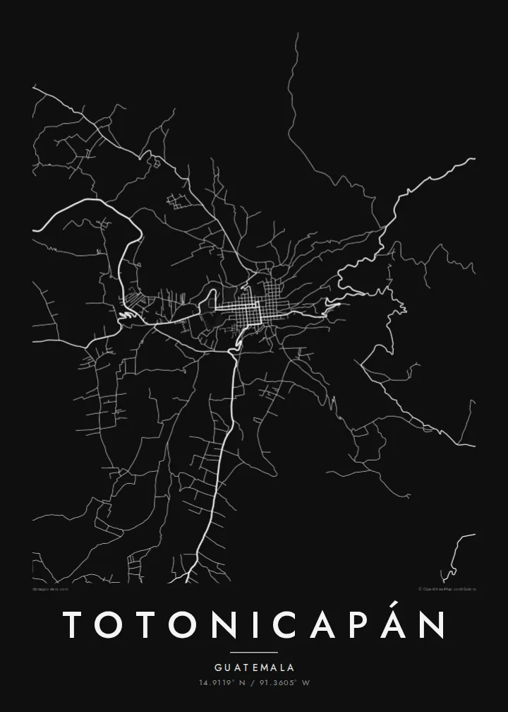
The main plaza anchors the older part of town, with a tight block pattern around it that forms the densest cluster of lines on the poster.
Postè kat minimalis · Guatemala
14.9119° N / 91.3605° W
A highland town climbing the sides of a narrow valley, its streets bending with the slopes of the western Guatemalan mountains.



Yon vil, senk atmosfè
Peze yon style pou wè li sou mi a. Chak style koute menm pri — enprime, ankadre oswa kòm fichye HD.
 Piksèl reyèl · fichye enpresyon 24 × 36″
Byen klè pou enprime
Sa a se yon zoom 100% sou vrè fichye enpresyon an. Chak afich — enprime, ankadre oswa telechaje — jenere sou sèvè nou yo nan 300 DPI, jiska 7,200 × 10,800 piksèl, konsa menm pi piti wout yo rete klè sou yon enpresyon 24 × 36″.
Sou mi a


Kat la
Totonicapán lies high in the western highlands of Guatemala, at roughly 2,500 metres, and is the capital of the department of the same name. The town fills a valley floor and spreads up the surrounding slopes. Its map therefore combines a compact centre around the main square with streets that twist and switch back where the ground rises.
Most of the population is K'iche' Maya. Totonicapán is known for a strong tradition of communal self-government through the 48 Cantones, and for crafts such as weaving, pottery and carved wooden masks. The pine forests on the hills above town have long been managed by local communities. On the map they frame the settlement as open space around a dense core.
A Totonicapán map poster captures a town shaped more by terrain than by planning. Around the centre the streets are close and regular. Further out they follow ridges and gullies, breaking into irregular lines that give the print texture and movement. For a small mountain town, the result is surprisingly graphic.
The main plaza anchors the older part of town, with a tight block pattern around it that forms the densest cluster of lines on the poster.
Beyond the centre, roads curve and zigzag with the terrain, a clear sign on the map of how steep the valley sides are.
The hills around the town, covered in communally managed pine forest, appear as open areas that let the compact urban shape stand out.
Fè l pou ou
Ajoute yon dat, yon non oswa pwòp fraz pa w, chanje estil, gwosè oswa oryantasyon.
Apèsi gratis la se nan rezolisyon ba avèk yon watèrmak. Enpresyon ak fichye HD yo jenere nan 300 DPI, jiska 7,200 × 10,800 px, san watèrmak.
Poukisa Totonicapán
Many families from Totonicapán live far away, in Guatemala City or abroad, and a map of the town is a simple way to keep its streets present. Add a family name, a date or a line in K'iche' or Spanish as the subtitle, and set the coordinates to your own house or cantón.
The map comes in five styles: Classic black & white, Noir, Paper, Blueprint and Sand. For $9 you receive 300 DPI PNG and print-ready PDF files in six sizes, including A3, A2 and 24×36″. You can also order a matte print, framed if you like, from partners in 30+ countries.
Kòmande afich Totonicapán a| Gwosè enpresyon | Rezolisyon | Fichye |
|---|---|---|
| 30 × 40 cm11.8 × 15.7″ | 3,543 × 4,724 px | PNG · PDF |
| 29.7 × 42 cm (A3)11.7 × 16.5″ | 3,508 × 4,961 px | PNG · PDF |
| 42 × 59.4 cm (A2)16.5 × 23.4″ | 4,961 × 7,016 px | PNG · PDF |
| 45.7 × 61 cm18 × 24″ | 5,400 × 7,200 px | PNG · PDF |
| 50 × 70 cm19.7 × 27.6″ | 5,906 × 8,268 px | PNG · PDF |
| 61 × 91.4 cm24 × 36″ | 7,200 × 10,800 px | PNG · PDF |
Pou konpare, apèsi gratis la gen 900 px lajè, li gen filigràn epi li fèt pou ekran. Fichye HD yo gen jiska 8 fwa plis rezolisyon nan chak direksyon epi yo enprime pwòp nan gwosè postè konplè.
Chwazi yon style anlè paj la, epi chwazi Afich Enprime — yon gwosè epi, si w vle, yon kad — oswa Fichye Dijital HD. Peman an fèt nan yon sèl etap, epi paj kòmand ou a mete ajou kou peman an konfime.
Li enprime sou papye mat premium 200 gsm nan youn nan sis gwosè, soti nan 30 × 40 cm rive nan 24 × 36″. Afich enprime yo kòmanse nan $39, livrezon enkli.
Wi. Chwazi yon kad an bwa solid nan koulè nwa, blan, chenn natirèl oswa bwa fonse. Li vin ak yon vit ki pa kase epi li pare pou pandye. Afich ankadre yo kòmanse nan $99, livrezon enkli.
Livrezon gratis nan plis pase 60 peyi. Chak afich enprime pa patnè enprimeri ki pi pre w la nan plis pase 30 peyi, e anjeneral li rive nan 3 a 7 jou ouvrab. Ou ka suiv estati a ak swivi kolis la nan Kòmand mwen yo. Kèk peyi pran 2 a 5 semèn, e kote nou poko livre, sit la di w sa anvan w peye.
Voye nou yon foto nan 14 jou apre livrezon an epi nou ap reenprime li gratis oswa remèt ou lajan w.
Wi. Nan editè a sou paj sa a, chanje tit la, soutit la ak liy kowòdone yo pou nenpòt sa w vle, epi chwazi yon style ak yon gwosè. Kòmand enprime, ankadre ak dijital yo tout itilize egzakteman desen w lan.
Pou $9 ou jwenn fichye PNG 300 DPI ak PDF pare-pou-enprime nan tout sis gwosè yo, san watèrmak, pou enprime kote w vle. Pa sèten toujou? Telechaje yon apèsi gratis ak watèrmak anvan.
