Colonial grid
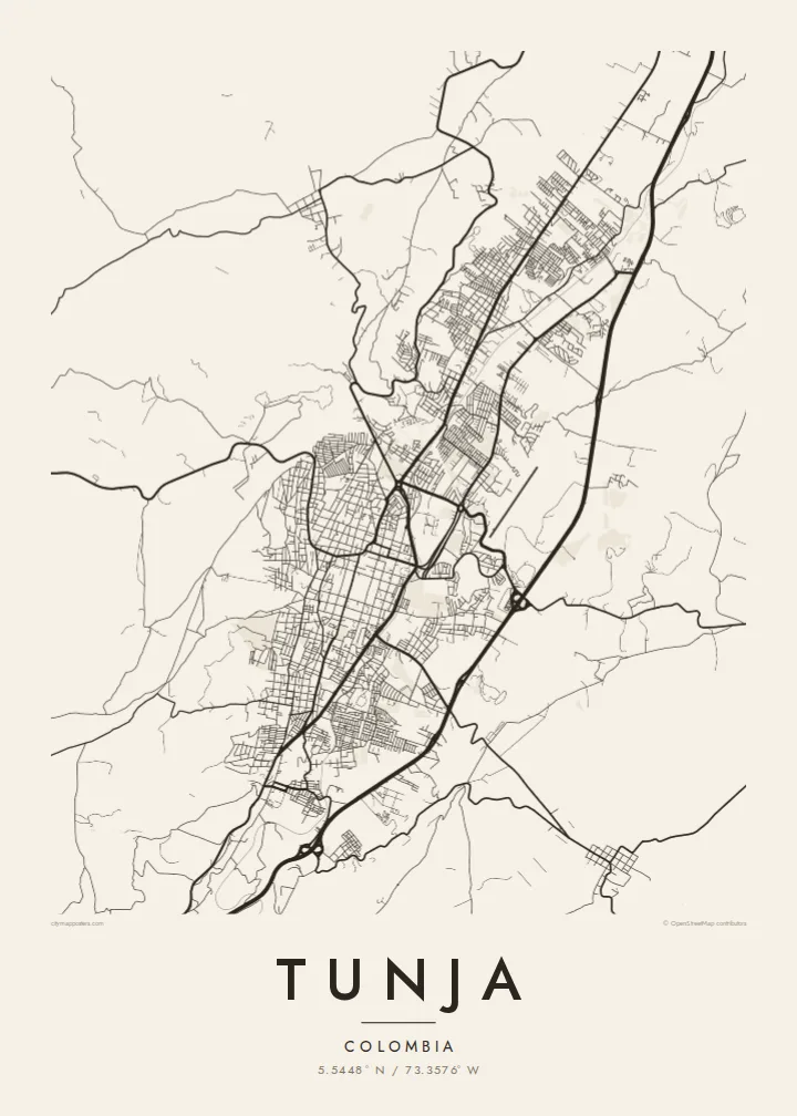
The historic centre keeps its original checkerboard around the Plaza de Bolívar, a square of regular blocks that stands out clearly at the middle of the map.
Postè kat minimalis · Colombia
5.5448° N / 73.3576° W
A high Andean capital laid out in a colonial grid, stretched north to south along a narrow valley between green ridges.




Yon vil, senk atmosfè
Peze yon style pou wè li sou mi a. Chak style koute menm pri — enprime, ankadre oswa kòm fichye HD.
 Piksèl reyèl · fichye enpresyon 24 × 36″
Byen klè pou enprime
Sa a se yon zoom 100% sou vrè fichye enpresyon an. Chak afich — enprime, ankadre oswa telechaje — jenere sou sèvè nou yo nan 300 DPI, jiska 7,200 × 10,800 piksèl, konsa menm pi piti wout yo rete klè sou yon enpresyon 24 × 36″.
Sou mi a


Kat la
Tunja, the capital of Boyacá, sits at around 2,800 metres, making it one of the highest departmental capitals in Colombia. It lies in a narrow valley running roughly north to south, and the city has grown along that axis rather than outward. On the map the result is an elongated shape, with the colonial centre near the middle and newer districts reaching up the slopes on either side.
Founded by the Spanish in 1539 on the site of a Muisca settlement, Tunja kept its checkerboard plan around the Plaza de Bolívar, one of the largest main squares in the country. Churches and colonial houses line the surrounding blocks. About fifteen kilometres to the south lies the Puente de Boyacá, where the decisive battle for independence was fought in 1819.
A Tunja map poster shows a city defined by both history and terrain. The regular grid of the old centre sits at the heart of the frame, main avenues run along the valley, and the streets bend and thin out where they meet the hills. It is a meaningful map for boyacenses at home or abroad, and for students of the city's universities.
The historic centre keeps its original checkerboard around the Plaza de Bolívar, a square of regular blocks that stands out clearly at the middle of the map.
The city stretches north to south along its valley, with main avenues following the same line and giving the poster a strong vertical composition.
On the edges, newer neighbourhoods climb the slopes, where streets curve with the contours and the tidy grid gives way to a looser, more organic pattern.
Fè l pou ou
Ajoute yon dat, yon non oswa pwòp fraz pa w, chanje estil, gwosè oswa oryantasyon.
Apèsi gratis la se nan rezolisyon ba avèk yon watèrmak. Enpresyon ak fichye HD yo jenere nan 300 DPI, jiska 7,200 × 10,800 px, san watèrmak.
Poukisa Tunja
Tunja is a city of students and of families with deep Boyacá roots. A map of its grid and valley is a thoughtful way to remember university years, a hometown or the place near which Colombian independence was won.
The title, subtitle and coordinates line can be personalised with a name, graduation year or date, and five styles are available: Classic black & white, Noir, Paper, Blueprint and Sand. Paper suits the colonial centre especially well.
Kòmande afich Tunja a| Gwosè enpresyon | Rezolisyon | Fichye |
|---|---|---|
| 30 × 40 cm (11.8 × 15.7″) | 3,543 × 4,724 px | PNG · PDF |
| 29.7 × 42 cm (A3, 11.7 × 16.5″) | 3,508 × 4,961 px | PNG · PDF |
| 42 × 59.4 cm (A2, 16.5 × 23.4″) | 4,961 × 7,016 px | PNG · PDF |
| 45.7 × 61 cm (18 × 24″) | 5,400 × 7,200 px | PNG · PDF |
| 50 × 70 cm (19.7 × 27.6″) | 5,906 × 8,268 px | PNG · PDF |
| 61 × 91.4 cm (24 × 36″) | 7,200 × 10,800 px | PNG · PDF |
Pou konpare, apèsi gratis la gen 900 px lajè, li gen filigràn epi li fèt pou ekran. Fichye HD yo gen jiska 8 fwa plis rezolisyon nan chak direksyon epi yo enprime pwòp nan gwosè postè konplè.
Chwazi yon style anlè paj la, epi chwazi Afich Enprime — yon gwosè epi, si w vle, yon kad — oswa Fichye Dijital HD. Peman an fèt nan yon sèl etap, epi paj kòmand ou a mete ajou kou peman an konfime.
Li enprime sou papye mat premium 200 gsm nan youn nan sis gwosè, soti nan 30 × 40 cm rive nan 24 × 36″. Afich enprime yo kòmanse nan {printFrom}, livrezon enkli.
Wi. Chwazi yon kad an bwa solid nan koulè nwa, blan, chenn natirèl oswa bwa fonse. Li vin ak yon vit ki pa kase epi li pare pou pandye. Afich ankadre yo kòmanse nan {framedFrom}, livrezon enkli.
Livrezon an gratis nan tout mond lan. Se pi pwòch nan patnè enprimri nou yo nan plis pase 30 peyi ki enprime chak afich la, epi li anjeneral rive nan 3–7 jou ouvrab. Ou ka swiv estati ak swivi kolis la nan Kòmand mwen yo. Gen kèk peyi ki pran 2–5 semèn, e kote nou poko livre a, sit la di w anvan ou peye.
Voye nou yon foto nan 14 jou apre livrezon an epi nou ap reenprime li gratis oswa remèt ou lajan w.
Wi. Nan editè a sou paj sa a, chanje tit la, soutit la ak liy kowòdone yo pou nenpòt sa w vle, epi chwazi yon style ak yon gwosè. Kòmand enprime, ankadre ak dijital yo tout itilize egzakteman desen w lan.
Pou $9 ou jwenn fichye PNG 300 DPI ak PDF pare-pou-enprime nan tout sis gwosè yo, san watèrmak, pou enprime kote w vle. Pa sèten toujou? Telechaje yon apèsi gratis ak watèrmak anvan.
