Ría de Arousa
The largest of the Galician estuaries opens beside the town, forming a broad expanse of water that frames the map and defines the local way of life.
Postè kat minimalis · Spain
42.5963° N / 8.7643° W
A Galician port town on the Ría de Arousa, its streets running down to harbours, beaches and mussel-farm waters



Yon vil, senk atmosfè
Peze yon style pou wè li sou mi a. Chak style koute menm pri — enprime, ankadre oswa kòm fichye HD.
 Piksèl reyèl · fichye enpresyon 24 × 36″
Byen klè pou enprime
Sa a se yon zoom 100% sou vrè fichye enpresyon an. Chak afich — enprime, ankadre oswa telechaje — jenere sou sèvè nou yo nan 300 DPI, jiska 7,200 × 10,800 piksèl, konsa menm pi piti wout yo rete klè sou yon enpresyon 24 × 36″.
Sou mi a


Kat la
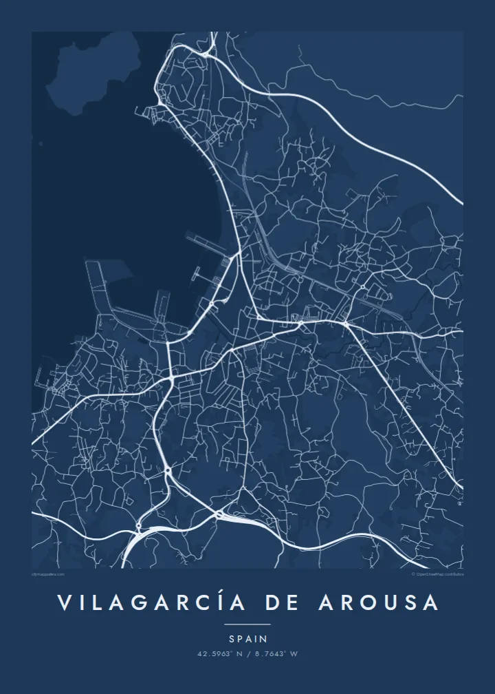
Vilagarcía de Arousa lies on the southern shore of the Ría de Arousa, the largest of the Galician estuaries. On a map the town follows the curve of the coast, with a port and waterfront along the shore, a dense centre just inland and residential areas climbing the green hills behind it. Beaches and small inlets break up the coastline on either side.
The Ría de Arousa is one of Europe's most productive areas for mussel farming, and the waters off Vilagarcía are dotted with the floating wooden rafts known as bateas. The neighbouring district of Carril is known for its clams, and the town's port handles fishing boats and cargo alike.
A Vilagarcía de Arousa map poster captures the close relationship between town and water. The shoreline curves around the bay, piers and harbour walls reach into the ría, and streets run down the slope toward the sea. In black and white the contrast between the solid land and open estuary becomes a strong, elegant composition.
The largest of the Galician estuaries opens beside the town, forming a broad expanse of water that frames the map and defines the local way of life.
Harbour walls, piers and a long seafront line the shore, giving the map sharp, geometric edges against the curving coastline.
The district of Carril, long known for its clams, sits along the shore where tidal flats and small harbours meet the edge of town.
Fè l pou ou
Ajoute yon dat, yon non oswa pwòp fraz pa w, chanje estil, gwosè oswa oryantasyon.
Apèsi gratis la se nan rezolisyon ba avèk yon watèrmak. Enpresyon ak fichye HD yo jenere nan 300 DPI, jiska 7,200 × 10,800 px, san watèrmak.
Poukisa Vilagarcía de Arousa
Vilagarcía de Arousa suits anyone who loves the Galician coast, from locals to visitors who came for its seafood and beaches. The shape of the ría makes the map instantly recognisable.
The title, subtitle and coordinates line can be edited to mark a summer, a family name or a special date. Choose from Classic black and white, Noir, Paper, Blueprint or Sand.
Kòmande afich Vilagarcía de Arousa a| Gwosè enpresyon | Rezolisyon | Fichye |
|---|---|---|
| 30 × 40 cm11.8 × 15.7″ | 3,543 × 4,724 px | PNG · PDF |
| 29.7 × 42 cm (A3)11.7 × 16.5″ | 3,508 × 4,961 px | PNG · PDF |
| 42 × 59.4 cm (A2)16.5 × 23.4″ | 4,961 × 7,016 px | PNG · PDF |
| 45.7 × 61 cm18 × 24″ | 5,400 × 7,200 px | PNG · PDF |
| 50 × 70 cm19.7 × 27.6″ | 5,906 × 8,268 px | PNG · PDF |
| 61 × 91.4 cm24 × 36″ | 7,200 × 10,800 px | PNG · PDF |
Pou konpare, apèsi gratis la gen 900 px lajè, li gen filigràn epi li fèt pou ekran. Fichye HD yo gen jiska 8 fwa plis rezolisyon nan chak direksyon epi yo enprime pwòp nan gwosè postè konplè.
Chwazi yon style anlè paj la, epi chwazi Afich Enprime — yon gwosè epi, si w vle, yon kad — oswa Fichye Dijital HD. Peman an fèt nan yon sèl etap, epi paj kòmand ou a mete ajou kou peman an konfime.
Li enprime sou papye mat premium 200 gsm nan youn nan sis gwosè, soti nan 30 × 40 cm rive nan 24 × 36″. Afich enprime yo kòmanse nan $39, livrezon enkli.
Wi. Chwazi yon kad an bwa solid nan koulè nwa, blan, chenn natirèl oswa bwa fonse. Li vin ak yon vit ki pa kase epi li pare pou pandye. Afich ankadre yo kòmanse nan $99, livrezon enkli.
Livrezon gratis nan plis pase 60 peyi. Chak afich enprime pa patnè enprimeri ki pi pre w la nan plis pase 30 peyi, e anjeneral li rive nan 3 a 7 jou ouvrab. Ou ka suiv estati a ak swivi kolis la nan Kòmand mwen yo. Kèk peyi pran 2 a 5 semèn, e kote nou poko livre, sit la di w sa anvan w peye.
Voye nou yon foto nan 14 jou apre livrezon an epi nou ap reenprime li gratis oswa remèt ou lajan w.
Wi. Nan editè a sou paj sa a, chanje tit la, soutit la ak liy kowòdone yo pou nenpòt sa w vle, epi chwazi yon style ak yon gwosè. Kòmand enprime, ankadre ak dijital yo tout itilize egzakteman desen w lan.
Pou $9 ou jwenn fichye PNG 300 DPI ak PDF pare-pou-enprime nan tout sis gwosè yo, san watèrmak, pou enprime kote w vle. Pa sèten toujou? Telechaje yon apèsi gratis ak watèrmak anvan.
Toupre
