Clear Creek corridor
The creek winds across the city at an angle to the streets. Its green corridor and trail form the most natural line in an otherwise straight-edged map.
Postè kat minimalis · United States
39.7661° N / 105.0772° W
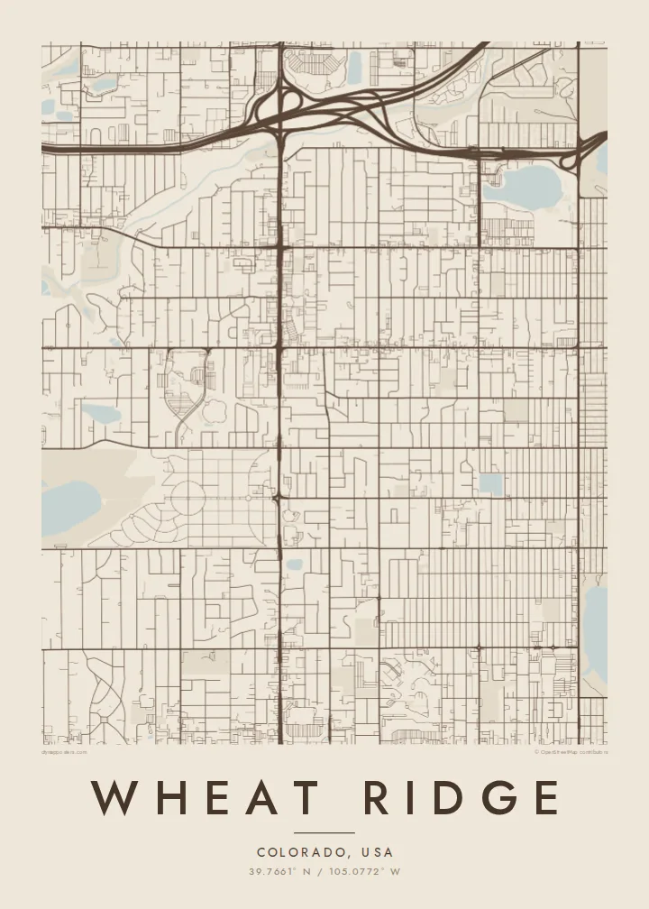
A suburban grid west of Denver, cut diagonally by Clear Creek and bordered by Interstate 70 to the north


Yon vil, senk atmosfè
Peze yon style pou wè li sou mi a. Chak style koute menm pri — enprime, ankadre oswa kòm fichye HD.
 Piksèl reyèl · fichye enpresyon 24 × 36″
Byen klè pou enprime
Sa a se yon zoom 100% sou vrè fichye enpresyon an. Chak afich — enprime, ankadre oswa telechaje — jenere sou sèvè nou yo nan 300 DPI, jiska 7,200 × 10,800 piksèl, konsa menm pi piti wout yo rete klè sou yon enpresyon 24 × 36″.
Sou mi a


Kat la
Wheat Ridge is a city in Jefferson County, Colorado, just west of Denver. Its streets follow the same north-south and east-west grid used across the Denver metro area, with long, straight avenues at regular intervals. The Rocky Mountain foothills are not far to the west, but the city itself sits on gently sloping ground.
Clear Creek breaks the grid. It runs diagonally across the city from west to east, and a trail and green corridor follow its banks. Interstate 70 passes along the northern edge. For much of the twentieth century Wheat Ridge was known for growing carnations and called itself the Carnation City.
A Wheat Ridge map poster shows a regular suburban grid, a winding creek and a highway at the edge. That mix of straight lines and one natural curve makes it an easy map to read and to hang.
The creek winds across the city at an angle to the streets. Its green corridor and trail form the most natural line in an otherwise straight-edged map.
Arterial avenues divide the city into regular square sections. On the poster, the evenly spaced lines give the layout a clean, measured structure.
The interstate runs along the northern side of the city. Its wide lanes and interchanges form a sharp border at the top of the composition.
Fè l pou ou
Ajoute yon dat, yon non oswa pwòp fraz pa w, chanje estil, gwosè oswa oryantasyon.
Apèsi gratis la se nan rezolisyon ba avèk yon watèrmak. Enpresyon ak fichye HD yo jenere nan 300 DPI, jiska 7,200 × 10,800 px, san watèrmak.
Poukisa Wheat Ridge
For people who have bought a house here, grew up nearby or ride the Clear Creek Trail, the map is a quiet image of the neighbourhood. It works as a housewarming gift for someone who has just moved to the west side of Denver.
Put a family name in the title, add a move-in date to the subtitle, and edit the coordinates line. Choose from Classic black & white, Noir, Paper, Blueprint and Sand.
Kòmande afich Wheat Ridge a| Gwosè enpresyon | Rezolisyon | Fichye |
|---|---|---|
| 30 × 40 cm11.8 × 15.7″ | 3,543 × 4,724 px | PNG · PDF |
| 29.7 × 42 cm (A3)11.7 × 16.5″ | 3,508 × 4,961 px | PNG · PDF |
| 42 × 59.4 cm (A2)16.5 × 23.4″ | 4,961 × 7,016 px | PNG · PDF |
| 45.7 × 61 cm18 × 24″ | 5,400 × 7,200 px | PNG · PDF |
| 50 × 70 cm19.7 × 27.6″ | 5,906 × 8,268 px | PNG · PDF |
| 61 × 91.4 cm24 × 36″ | 7,200 × 10,800 px | PNG · PDF |
Pou konpare, apèsi gratis la gen 900 px lajè, li gen filigràn epi li fèt pou ekran. Fichye HD yo gen jiska 8 fwa plis rezolisyon nan chak direksyon epi yo enprime pwòp nan gwosè postè konplè.
Chwazi yon style anlè paj la, epi chwazi Afich Enprime — yon gwosè epi, si w vle, yon kad — oswa Fichye Dijital HD. Peman an fèt nan yon sèl etap, epi paj kòmand ou a mete ajou kou peman an konfime.
Li enprime sou papye mat premium 200 gsm nan youn nan sis gwosè, soti nan 30 × 40 cm rive nan 24 × 36″. Afich enprime yo kòmanse nan $39, livrezon enkli.
Wi. Chwazi yon kad an bwa solid nan koulè nwa, blan, chenn natirèl oswa bwa fonse. Li vin ak yon vit ki pa kase epi li pare pou pandye. Afich ankadre yo kòmanse nan $99, livrezon enkli.
Livrezon gratis nan plis pase 60 peyi. Chak afich enprime pa patnè enprimeri ki pi pre w la nan plis pase 30 peyi, e anjeneral li rive nan 3 a 7 jou ouvrab. Ou ka suiv estati a ak swivi kolis la nan Kòmand mwen yo. Kèk peyi pran 2 a 5 semèn, e kote nou poko livre, sit la di w sa anvan w peye.
Voye nou yon foto nan 14 jou apre livrezon an epi nou ap reenprime li gratis oswa remèt ou lajan w.
Wi. Nan editè a sou paj sa a, chanje tit la, soutit la ak liy kowòdone yo pou nenpòt sa w vle, epi chwazi yon style ak yon gwosè. Kòmand enprime, ankadre ak dijital yo tout itilize egzakteman desen w lan.
Pou $9 ou jwenn fichye PNG 300 DPI ak PDF pare-pou-enprime nan tout sis gwosè yo, san watèrmak, pou enprime kote w vle. Pa sèten toujou? Telechaje yon apèsi gratis ak watèrmak anvan.
