River Ruhr
The river winds through the valley south of the centre, its broad curves and bridges giving the lower part of the map a strong, flowing line.
Postè kat minimalis · Germany
51.4436° N / 7.3526° E
A Ruhr town beside a winding river, its streets spreading from the centre down to the water and the wooded valley



Yon vil, senk atmosfè
Peze yon style pou wè li sou mi a. Chak style koute menm pri — enprime, ankadre oswa kòm fichye HD.
 Piksèl reyèl · fichye enpresyon 24 × 36″
Byen klè pou enprime
Sa a se yon zoom 100% sou vrè fichye enpresyon an. Chak afich — enprime, ankadre oswa telechaje — jenere sou sèvè nou yo nan 300 DPI, jiska 7,200 × 10,800 piksèl, konsa menm pi piti wout yo rete klè sou yon enpresyon 24 × 36″.
Sou mi a


Kat la
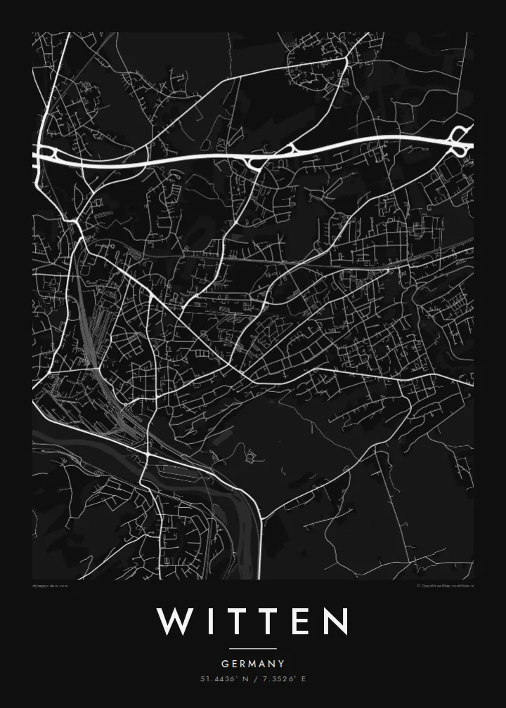
Witten lies on the southern edge of the Ruhr area, on the River Ruhr, between Bochum and Hagen. On the map, the river loops along the town's southern side, with the Kemnader See reservoir to the west, and wooded slopes rising above the valley. The town centre sits slightly back from the river on higher ground, with districts spreading in all directions.
Witten is often described as a cradle of Ruhr coal mining. In the Muttental valley, just outside the centre, coal was mined from surface seams long before the large collieries of the northern Ruhr, and a mining history trail now follows the old sites. The town is also home to Witten/Herdecke University, one of Germany's first private universities.
A Witten map poster shows a town with more green and water than one might expect of the Ruhr. The curve of the river, the reservoir, the forested valleys and the dense core all come together, and in black and white the balance between town and landscape is clear.
The river winds through the valley south of the centre, its broad curves and bridges giving the lower part of the map a strong, flowing line.
The reservoir on the Ruhr, shared with Bochum, forms a long, smooth shape on the western side, bordered by paths and green banks.
The wooded valley south of the centre, where early coal mining took place, appears as a green corridor threaded by small roads and footpaths.
Fè l pou ou
Ajoute yon dat, yon non oswa pwòp fraz pa w, chanje estil, gwosè oswa oryantasyon.
Apèsi gratis la se nan rezolisyon ba avèk yon watèrmak. Enpresyon ak fichye HD yo jenere nan 300 DPI, jiska 7,200 × 10,800 px, san watèrmak.
Poukisa Witten
Witten is a place with deep roots for Ruhr families and a strong attachment for students and staff of its university. A map of the town, the river and the valleys is a meaningful and understated image to live with.
Personalise the title, subtitle and coordinates line with a name, a year or a few words. Choose Classic black & white, Noir, Paper, Blueprint or Sand to suit your space.
Kòmande afich Witten a| Gwosè enpresyon | Rezolisyon | Fichye |
|---|---|---|
| 30 × 40 cm (11.8 × 15.7″) | 3,543 × 4,724 px | PNG · PDF |
| 29.7 × 42 cm (A3, 11.7 × 16.5″) | 3,508 × 4,961 px | PNG · PDF |
| 42 × 59.4 cm (A2, 16.5 × 23.4″) | 4,961 × 7,016 px | PNG · PDF |
| 45.7 × 61 cm (18 × 24″) | 5,400 × 7,200 px | PNG · PDF |
| 50 × 70 cm (19.7 × 27.6″) | 5,906 × 8,268 px | PNG · PDF |
| 61 × 91.4 cm (24 × 36″) | 7,200 × 10,800 px | PNG · PDF |
Pou konpare, apèsi gratis la gen 900 px lajè, li gen filigràn epi li fèt pou ekran. Fichye HD yo gen jiska 8 fwa plis rezolisyon nan chak direksyon epi yo enprime pwòp nan gwosè postè konplè.
Chwazi yon style anlè paj la, epi chwazi Afich Enprime — yon gwosè epi, si w vle, yon kad — oswa Fichye Dijital HD. Peman an fèt nan yon sèl etap, epi paj kòmand ou a mete ajou kou peman an konfime.
Li enprime sou papye mat premium 200 gsm nan youn nan sis gwosè, soti nan 30 × 40 cm rive nan 24 × 36″. Afich enprime yo kòmanse nan {printFrom}, livrezon enkli.
Wi. Chwazi yon kad an bwa solid nan koulè nwa, blan, chenn natirèl oswa bwa fonse. Li vin ak yon vit ki pa kase epi li pare pou pandye. Afich ankadre yo kòmanse nan {framedFrom}, livrezon enkli.
Livrezon an gratis nan tout mond lan. Se pi pwòch nan patnè enprimri nou yo nan plis pase 30 peyi ki enprime chak afich la, epi li anjeneral rive nan 3–7 jou ouvrab. Ou ka swiv estati ak swivi kolis la nan Kòmand mwen yo. Gen kèk peyi ki pran 2–5 semèn, e kote nou poko livre a, sit la di w anvan ou peye.
Voye nou yon foto nan 14 jou apre livrezon an epi nou ap reenprime li gratis oswa remèt ou lajan w.
Wi. Nan editè a sou paj sa a, chanje tit la, soutit la ak liy kowòdone yo pou nenpòt sa w vle, epi chwazi yon style ak yon gwosè. Kòmand enprime, ankadre ak dijital yo tout itilize egzakteman desen w lan.
Pou $9 ou jwenn fichye PNG 300 DPI ak PDF pare-pou-enprime nan tout sis gwosè yo, san watèrmak, pou enprime kote w vle. Pa sèten toujou? Telechaje yon apèsi gratis ak watèrmak anvan.
