Elbe waterfront
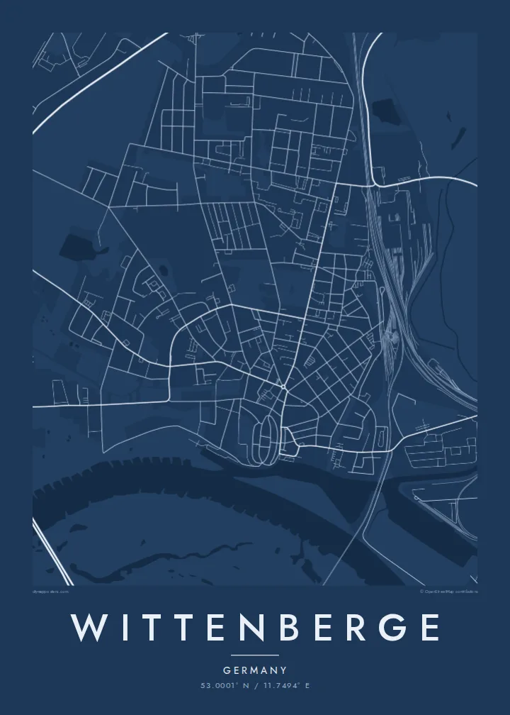
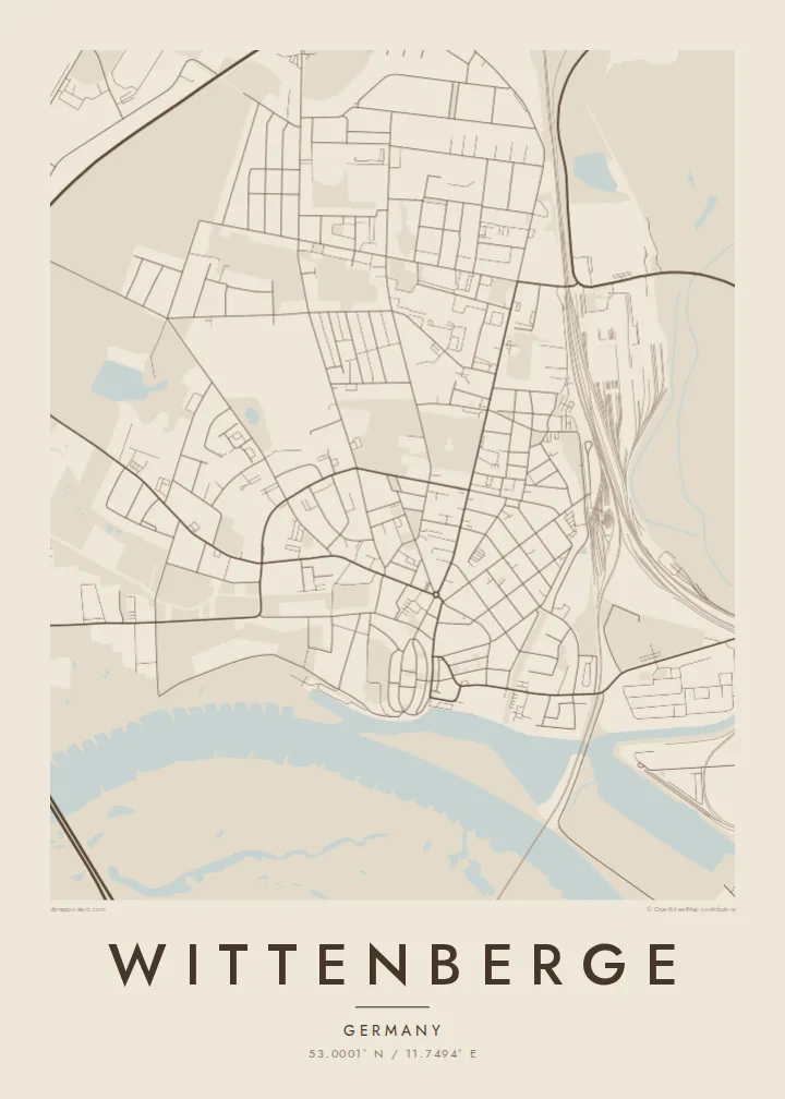
The broad river passes along the south of the town, bordered by dikes and floodplain meadows that open up large areas of the map.
Postè kat minimalis · Germany
53.0001° N / 11.7494° E
An Elbe river town where the Stepenitz flows in, with rail yards, a harbour and a landmark factory clock tower.


Yon vil, senk atmosfè
Peze yon style pou wè li sou mi a. Chak style koute menm pri — enprime, ankadre oswa kòm fichye HD.
 Piksèl reyèl · fichye enpresyon 24 × 36″
Byen klè pou enprime
Sa a se yon zoom 100% sou vrè fichye enpresyon an. Chak afich — enprime, ankadre oswa telechaje — jenere sou sèvè nou yo nan 300 DPI, jiska 7,200 × 10,800 piksèl, konsa menm pi piti wout yo rete klè sou yon enpresyon 24 × 36″.
Sou mi a


Kat la
Wittenberge sits on the right bank of the Elbe in the Prignitz district of Brandenburg, roughly halfway between Berlin and Hamburg. On the map, the river curves broadly past the town's southern edge, and the smaller Stepenitz joins it near the old harbour. Behind the waterfront, a regular grid of streets from the industrial era extends inland toward the railway.
The town grew in the nineteenth century as a river port and a rail junction on the Berlin–Hamburg line. Its best-known landmark is the clock tower of the former Singer sewing machine factory, one of the largest freestanding clock towers in Europe. Oil mills, a harbour and the rail works all contributed to the town's industrial layout.
A Wittenberge map poster focuses on the river. The wide Elbe, its floodplain meadows and protective dikes take up much of the frame, while the town's orderly streets, railway tracks and harbour basins sit along one side. The Elbe bridge crossing to the left bank adds a strong horizontal line across the water.
The broad river passes along the south of the town, bordered by dikes and floodplain meadows that open up large areas of the map.
The smaller river meets the Elbe near the historic harbour, where basins and quays form the industrial core of the waterfront.
Tracks and yards cut through the town on the Berlin–Hamburg route, a network of long parallel lines typical of a nineteenth-century rail town.
Fè l pou ou
Ajoute yon dat, yon non oswa pwòp fraz pa w, chanje estil, gwosè oswa oryantasyon.
Apèsi gratis la se nan rezolisyon ba avèk yon watèrmak. Enpresyon ak fichye HD yo jenere nan 300 DPI, jiska 7,200 × 10,800 px, san watèrmak.
Poukisa Wittenberge
Wittenberge is a town defined by its river and its industry, and a map shows both at once. For people from the Prignitz or anyone who has cycled the Elbe route, it is a clear portrait of the river bend they know.
Personalise the title, subtitle and coordinates, and pick a style. Blueprint suits the industrial waterfront, but Classic, Noir, Paper and Sand are also available. Digital files and printed posters are both available.
Kòmande afich Wittenberge a| Gwosè enpresyon | Rezolisyon | Fichye |
|---|---|---|
| 30 × 40 cm11.8 × 15.7″ | 3,543 × 4,724 px | PNG · PDF |
| 29.7 × 42 cm (A3)11.7 × 16.5″ | 3,508 × 4,961 px | PNG · PDF |
| 42 × 59.4 cm (A2)16.5 × 23.4″ | 4,961 × 7,016 px | PNG · PDF |
| 45.7 × 61 cm18 × 24″ | 5,400 × 7,200 px | PNG · PDF |
| 50 × 70 cm19.7 × 27.6″ | 5,906 × 8,268 px | PNG · PDF |
| 61 × 91.4 cm24 × 36″ | 7,200 × 10,800 px | PNG · PDF |
Pou konpare, apèsi gratis la gen 900 px lajè, li gen filigràn epi li fèt pou ekran. Fichye HD yo gen jiska 8 fwa plis rezolisyon nan chak direksyon epi yo enprime pwòp nan gwosè postè konplè.
Chwazi yon style anlè paj la, epi chwazi Afich Enprime — yon gwosè epi, si w vle, yon kad — oswa Fichye Dijital HD. Peman an fèt nan yon sèl etap, epi paj kòmand ou a mete ajou kou peman an konfime.
Li enprime sou papye mat premium 200 gsm nan youn nan sis gwosè, soti nan 30 × 40 cm rive nan 24 × 36″. Afich enprime yo kòmanse nan $39, livrezon enkli.
Wi. Chwazi yon kad an bwa solid nan koulè nwa, blan, chenn natirèl oswa bwa fonse. Li vin ak yon vit ki pa kase epi li pare pou pandye. Afich ankadre yo kòmanse nan $99, livrezon enkli.
Livrezon gratis nan plis pase 60 peyi. Chak afich enprime pa patnè enprimeri ki pi pre w la nan plis pase 30 peyi, e anjeneral li rive nan 3 a 7 jou ouvrab. Ou ka suiv estati a ak swivi kolis la nan Kòmand mwen yo. Kèk peyi pran 2 a 5 semèn, e kote nou poko livre, sit la di w sa anvan w peye.
Voye nou yon foto nan 14 jou apre livrezon an epi nou ap reenprime li gratis oswa remèt ou lajan w.
Wi. Nan editè a sou paj sa a, chanje tit la, soutit la ak liy kowòdone yo pou nenpòt sa w vle, epi chwazi yon style ak yon gwosè. Kòmand enprime, ankadre ak dijital yo tout itilize egzakteman desen w lan.
Pou $9 ou jwenn fichye PNG 300 DPI ak PDF pare-pou-enprime nan tout sis gwosè yo, san watèrmak, pou enprime kote w vle. Pa sèten toujou? Telechaje yon apèsi gratis ak watèrmak anvan.
