Yalu River channels
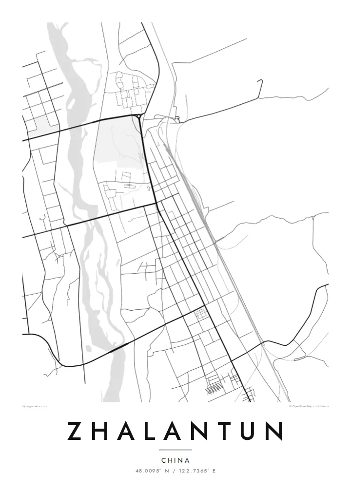
The river divides into several braided arms through town, leaving islands and green strips that break up the street pattern in fluid, irregular shapes.
Postè kat minimalis · China
48.0095° N / 122.7365° E
A long valley town following the Yalu River out of the Greater Khingan foothills, with streets strung along the water and rail


Yon vil, senk atmosfè
Peze yon style pou wè li sou mi a. Chak style koute menm pri — enprime, ankadre oswa kòm fichye HD.
 Piksèl reyèl · fichye enpresyon 24 × 36″
Byen klè pou enprime
Sa a se yon zoom 100% sou vrè fichye enpresyon an. Chak afich — enprime, ankadre oswa telechaje — jenere sou sèvè nou yo nan 300 DPI, jiska 7,200 × 10,800 piksèl, konsa menm pi piti wout yo rete klè sou yon enpresyon 24 × 36″.
Sou mi a


Kat la
Zhalantun lies in the far east of Inner Mongolia, where the forested slopes of the Greater Khingan range drop toward the Songnen plain. The city stretches along the valley of the Yalu River, a tributary of the Nen. That gives the street plan a stretched, directional shape rather than a round centre. Hills close in on both sides, and the river braids through the middle.
The railway that once formed part of the Chinese Eastern line runs through the valley, and the town grew around its stations. Today Zhalantun is known across the region for its landscape: river islands, wooded ridges and parks that fold into the urban edge. On a map this appears as a city that keeps giving way to terrain.
A Zhalantun map poster picks up that tension between grid and valley. Blocks line up neatly near the rail corridor and then break apart where the river splits into channels and islands. Contours are not drawn, but you can read them in the gaps. Streets end where the slopes begin, and the valley floor holds almost everything built.
The river divides into several braided arms through town, leaving islands and green strips that break up the street pattern in fluid, irregular shapes.
The historic east–west railway runs straight along the valley floor, and the denser blocks of the city are aligned with it.
Hills press in from both sides, so the built area ends in sharp lines where slopes begin, a boundary that reads clearly in black and white.
Fè l pou ou
Ajoute yon dat, yon non oswa pwòp fraz pa w, chanje estil, gwosè oswa oryantasyon.
Apèsi gratis la se nan rezolisyon ba avèk yon watèrmak. Enpresyon ak fichye HD yo jenere nan 300 DPI, jiska 7,200 × 10,800 px, san watèrmak.
Poukisa Zhalantun
Zhalantun appeals to people who value the place where a town meets wild country. The map shows a city shaped by its river and ridges, a steady reminder of northern forests and long rail journeys, and it suits a calm, uncluttered room.
Add a title, a subtitle and a coordinates line of your choosing, perhaps a family name or a year you moved. Then pick Classic black & white, Noir, Paper, Blueprint or Sand. Paper and Sand bring out the softer river forms.
Kòmande afich Zhalantun a| Gwosè enpresyon | Rezolisyon | Fichye |
|---|---|---|
| 30 × 40 cm11.8 × 15.7″ | 3,543 × 4,724 px | PNG · PDF |
| 29.7 × 42 cm (A3)11.7 × 16.5″ | 3,508 × 4,961 px | PNG · PDF |
| 42 × 59.4 cm (A2)16.5 × 23.4″ | 4,961 × 7,016 px | PNG · PDF |
| 45.7 × 61 cm18 × 24″ | 5,400 × 7,200 px | PNG · PDF |
| 50 × 70 cm19.7 × 27.6″ | 5,906 × 8,268 px | PNG · PDF |
| 61 × 91.4 cm24 × 36″ | 7,200 × 10,800 px | PNG · PDF |
Pou konpare, apèsi gratis la gen 900 px lajè, li gen filigràn epi li fèt pou ekran. Fichye HD yo gen jiska 8 fwa plis rezolisyon nan chak direksyon epi yo enprime pwòp nan gwosè postè konplè.
Chwazi yon style anlè paj la, epi chwazi Afich Enprime — yon gwosè epi, si w vle, yon kad — oswa Fichye Dijital HD. Peman an fèt nan yon sèl etap, epi paj kòmand ou a mete ajou kou peman an konfime.
Li enprime sou papye mat premium 200 gsm nan youn nan sis gwosè, soti nan 30 × 40 cm rive nan 24 × 36″. Afich enprime yo kòmanse nan $39, livrezon enkli.
Wi. Chwazi yon kad an bwa solid nan koulè nwa, blan, chenn natirèl oswa bwa fonse. Li vin ak yon vit ki pa kase epi li pare pou pandye. Afich ankadre yo kòmanse nan $99, livrezon enkli.
Livrezon gratis nan plis pase 60 peyi. Chak afich enprime pa patnè enprimeri ki pi pre w la nan plis pase 30 peyi, e anjeneral li rive nan 3 a 7 jou ouvrab. Ou ka suiv estati a ak swivi kolis la nan Kòmand mwen yo. Kèk peyi pran 2 a 5 semèn, e kote nou poko livre, sit la di w sa anvan w peye.
Voye nou yon foto nan 14 jou apre livrezon an epi nou ap reenprime li gratis oswa remèt ou lajan w.
Wi. Nan editè a sou paj sa a, chanje tit la, soutit la ak liy kowòdone yo pou nenpòt sa w vle, epi chwazi yon style ak yon gwosè. Kòmand enprime, ankadre ak dijital yo tout itilize egzakteman desen w lan.
Pou $9 ou jwenn fichye PNG 300 DPI ak PDF pare-pou-enprime nan tout sis gwosè yo, san watèrmak, pou enprime kote w vle. Pa sèten toujou? Telechaje yon apèsi gratis ak watèrmak anvan.
