Barrancas
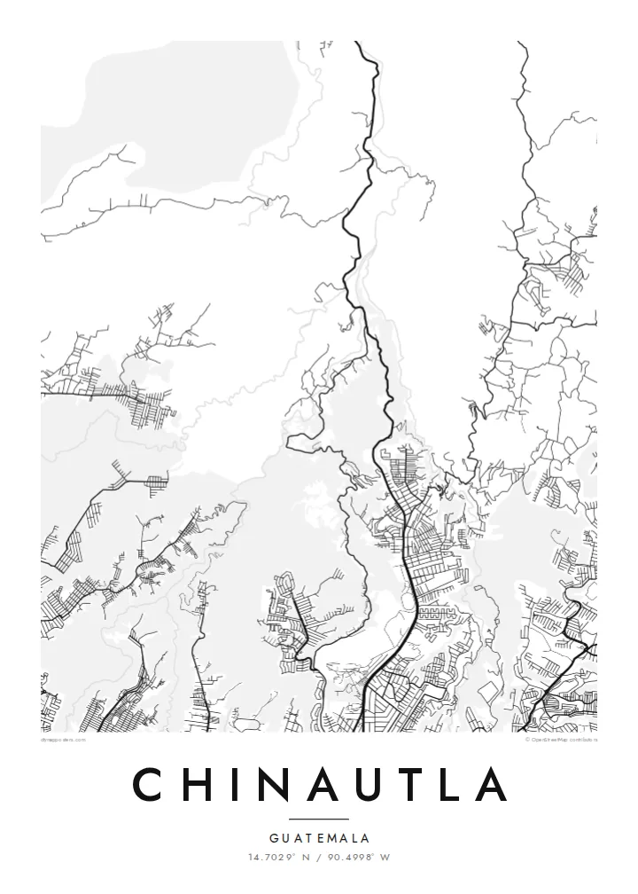
Steep ravines divide the municipality into separate ridges. On the map they appear as winding, unbuilt channels that give Chinautla its distinctive pattern.
Poster minimalista con mappa · Guatemala
14.7029° N / 90.4998° W
A municipality of deep ravines just north of Guatemala City, where neighbourhoods run along ridges and roads follow the terrain.


Una città, cinque atmosfere
Tocca uno stile per vederlo a parete. Ogni stile costa lo stesso — stampato, incorniciato o in file HD.
 Pixel reali · file di stampa 24 × 36″
Nitido in stampa
Questo è un ritaglio al 100% del vero file di stampa. Ogni poster — stampato, incorniciato o scaricato — viene renderizzato sui nostri server a 300 DPI, fino a 7,200 × 10,800 pixel, così anche le strade più piccole restano nitide su una stampa 24 × 36″.
Sulla parete


La mappa
Chinautla lies just north of Guatemala City, and its map is shaped almost entirely by relief. The land is cut by deep barrancas, steep ravines carved by streams draining the valley. Neighbourhoods sit on the ridges and plateaus between them. The result is an irregular pattern of dense built-up fingers separated by winding, empty folds.
The municipality combines the fast-growing urban districts that border the capital with the older town of Chinautla Viejo, a Poqomam Maya community known for its pottery. Clay figures and vessels made there are among the recognised ceramic traditions of Guatemala.
A Chinautla map poster shows how people have settled a hard landscape. In monochrome, the ravines read as dark or empty channels, and the ridge-top streets as bright, tightly packed strands between them. It is an unusual, almost organic composition, very different from the grid of the city next door.
Steep ravines divide the municipality into separate ridges. On the map they appear as winding, unbuilt channels that give Chinautla its distinctive pattern.
Housing follows the high ground between ravines, forming long, dense fingers of streets that stop abruptly where the slopes drop away.
The older town, known for its Poqomam pottery tradition, sits apart from the newer districts closer to the capital.
Personalizzalo
Aggiungi una data, un nome o una frase tua, cambia stile, formato o orientamento.
L'anteprima gratuita è a bassa risoluzione e con filigrana. Stampe e file HD vengono renderizzati a 300 DPI, fino a 7,200 × 10,800 px, senza filigrana.
Perché Chinautla
For families from Chinautla and the northern edge of the capital, this map shows home in its true shape, ravines and all. It is a more personal choice than a generic Guatemala City print.
Add a title and subtitle in Spanish or English, set the coordinates, and choose Classic black & white, Noir, Paper, Blueprint or Sand. The HD files are $9, or order a matte printed poster with an optional wooden frame.
Ordina il poster Chinautla| Formato di stampa | Risoluzione | File |
|---|---|---|
| 30 × 40 cm11.8 × 15.7″ | 3,543 × 4,724 px | PNG · PDF |
| 29.7 × 42 cm (A3)11.7 × 16.5″ | 3,508 × 4,961 px | PNG · PDF |
| 42 × 59.4 cm (A2)16.5 × 23.4″ | 4,961 × 7,016 px | PNG · PDF |
| 45.7 × 61 cm18 × 24″ | 5,400 × 7,200 px | PNG · PDF |
| 50 × 70 cm19.7 × 27.6″ | 5,906 × 8,268 px | PNG · PDF |
| 61 × 91.4 cm24 × 36″ | 7,200 × 10,800 px | PNG · PDF |
Per confronto, l'anteprima gratuita è larga 900 px, ha la filigrana ed è pensata per gli schermi. I file HD hanno fino a 8 volte la risoluzione in ogni direzione e si stampano in modo nitido nel formato poster completo.
Scegli uno stile in cima alla pagina, poi seleziona Poster Stampato — una misura e, se vuoi, una cornice — oppure File Digitali HD. Il checkout richiede un solo passaggio e la pagina del tuo ordine si aggiorna non appena il pagamento va a buon fine.
Viene stampato su carta opaca premium da 200 gsm in una di sei misure, da 30 × 40 cm a 24 × 36″. I poster stampati partono da $39, spedizione inclusa.
Sì. Scegli una cornice in legno massello nera, bianca, in rovere naturale o legno scuro. Include un vetro infrangibile ed è pronta da appendere. I poster incorniciati partono da $99, spedizione inclusa.
La spedizione è gratuita in oltre 60 paesi. Ogni poster viene stampato dal partner di stampa più vicino tra quelli presenti in più di 30 paesi e di solito arriva in 3–7 giorni lavorativi. Puoi seguire lo stato e il tracciamento in I miei ordini. Per alcuni paesi servono 2–5 settimane e, se non spediamo ancora nel tuo, il sito ti avvisa prima del pagamento.
Inviaci una foto entro 14 giorni dalla consegna e lo ristamperemo gratuitamente o ti rimborseremo.
Sì. Nell'editor di questa pagina puoi modificare il titolo, il sottotitolo e la riga delle coordinate come preferisci, e scegliere stile e misura. Gli ordini stampati, incorniciati e digitali usano esattamente il tuo design.
Per $9 ricevi file PNG a 300 DPI e PDF pronti per la stampa in tutte e sei le misure, senza filigrana, da stampare ovunque. Non sei ancora sicuro? Scarica prima un'anteprima gratuita con filigrana.
Nelle vicinanze
