Dana Point Harbor
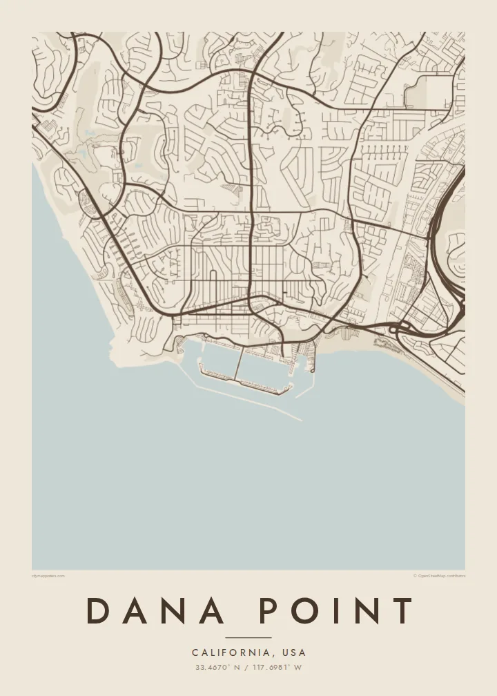
Long breakwaters enclose the harbour, creating a sheltered basin of marinas and boat slips that forms the most geometric shape on the coastline.
Poster minimalista con mappa · Stati Uniti
33.4670° N / 117.6981° W
A coastal city of headlands, a sheltered harbour and canyon streets, stepping down to the Pacific in Orange County.


Una città, cinque atmosfere
Tocca uno stile per vederlo a parete. Ogni stile costa lo stesso — stampato, incorniciato o in file HD.
 Pixel reali · file di stampa 24 × 36″
Nitido in stampa
Questo è un ritaglio al 100% del vero file di stampa. Ogni poster — stampato, incorniciato o scaricato — viene renderizzato sui nostri server a 300 DPI, fino a 7,200 × 10,800 pixel, così anche le strade più piccole restano nitide su una stampa 24 × 36″.
Sulla parete


La mappa
Dana Point lies on the southern Orange County coast, between Laguna Beach and San Clemente. The map is shaped by the shoreline: rocky headlands, sandy coves and a large man-made harbour protected by long breakwaters. Streets follow the hills and canyons inland, curving around slopes and opening onto terraces that step down to the Pacific.
The city takes its name from Richard Henry Dana Jr., who described the headland in Two Years Before the Mast, his account of a voyage along the California coast in the 1830s. Today Dana Point Harbor is the centre of the city's waterfront, with marinas and boat slips laid out in neat geometric patterns inside the breakwater.
South of the harbour, San Juan Creek reaches the sea at Doheny State Beach, and the coast continues toward Capistrano Beach. Dana Point is also known for whale watching, with gray whales passing offshore during their migration. A Dana Point map poster shows this interplay of harbour, headland, beach and hillside neighbourhoods in clean detail.
Long breakwaters enclose the harbour, creating a sheltered basin of marinas and boat slips that forms the most geometric shape on the coastline.
Rocky promontories break up the shoreline, including the headland that gave the city its name, forming bold outlines against the sea.
Where San Juan Creek meets the ocean, the beach spreads in a broad sandy curve, adding a soft edge next to the harbour.
Personalizzalo
Aggiungi una data, un nome o una frase tua, cambia stile, formato o orientamento.
L'anteprima gratuita è a bassa risoluzione e con filigrana. Stampe e file HD vengono renderizzati a 300 DPI, fino a 7,200 × 10,800 px, senza filigrana.
Perché Dana Point
Dana Point's coastline makes a striking map, with harbour, headlands and beaches all in one frame. It suits a beach house, a sailing enthusiast or anyone who has watched whales off this stretch of coast.
Add a title, subtitle and coordinates, and choose Classic black & white, Noir, Paper, Blueprint or Sand. The digital files are $9 for six sizes, including 18×24″ and 24×36″, with printed posters available too.
Ordina il poster Dana Point| Formato di stampa | Risoluzione | File |
|---|---|---|
| 30 × 40 cm (11.8 × 15.7″) | 3,543 × 4,724 px | PNG · PDF |
| 29.7 × 42 cm (A3, 11.7 × 16.5″) | 3,508 × 4,961 px | PNG · PDF |
| 42 × 59.4 cm (A2, 16.5 × 23.4″) | 4,961 × 7,016 px | PNG · PDF |
| 45.7 × 61 cm (18 × 24″) | 5,400 × 7,200 px | PNG · PDF |
| 50 × 70 cm (19.7 × 27.6″) | 5,906 × 8,268 px | PNG · PDF |
| 61 × 91.4 cm (24 × 36″) | 7,200 × 10,800 px | PNG · PDF |
Per confronto, l'anteprima gratuita è larga 900 px, ha la filigrana ed è pensata per gli schermi. I file HD hanno fino a 8 volte la risoluzione in ogni direzione e si stampano in modo nitido nel formato poster completo.
Scegli uno stile in cima alla pagina, poi seleziona Poster Stampato — una misura e, se vuoi, una cornice — oppure File Digitali HD. Il checkout richiede un solo passaggio e la pagina del tuo ordine si aggiorna non appena il pagamento va a buon fine.
Viene stampato su carta opaca premium da 200 gsm in una di sei misure, da 30 × 40 cm a 24 × 36″. I poster stampati partono da {printFrom}, spedizione inclusa.
Sì. Scegli una cornice in legno massello nera, bianca, in rovere naturale o legno scuro. Include un vetro infrangibile ed è pronta da appendere. I poster incorniciati partono da {framedFrom}, spedizione inclusa.
La spedizione è gratuita in tutto il mondo. Ogni poster viene stampato dal partner di stampa più vicino tra i nostri, in oltre 30 paesi, e di solito arriva in 3–7 giorni lavorativi. Puoi seguire stato e tracking in I Miei Ordini.
Inviaci una foto entro 14 giorni dalla consegna e lo ristamperemo gratuitamente o ti rimborseremo.
Sì. Nell'editor di questa pagina puoi modificare il titolo, il sottotitolo e la riga delle coordinate come preferisci, e scegliere stile e misura. Gli ordini stampati, incorniciati e digitali usano esattamente il tuo design.
Per $9 ricevi file PNG a 300 DPI e PDF pronti per la stampa in tutte e sei le misure, senza filigrana, da stampare ovunque. Non sei ancora sicuro? Scarica prima un'anteprima gratuita con filigrana.
Nelle vicinanze
