Ring around the centre
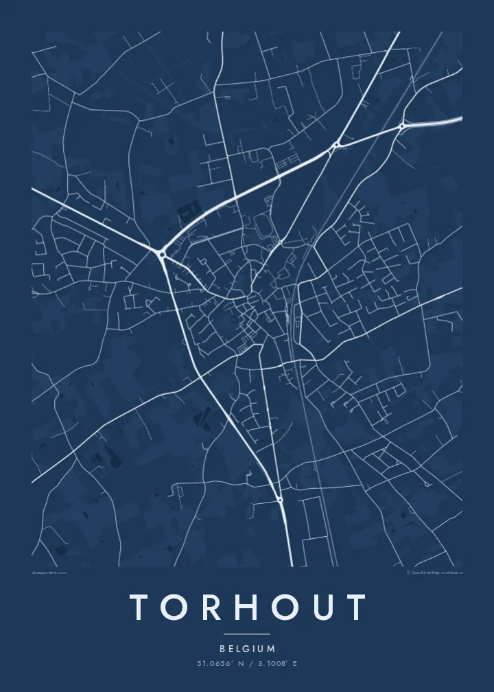
A ring road loops around the historic core. It gives the map a clear, almost circular frame that is easy to recognise at any size.
Poster minimalista con mappa · Belgio
51.0656° N / 3.1008° E
A West Flanders market town with a ring road around its centre and roads radiating across flat farmland



Una città, cinque atmosfere
Tocca uno stile per vederlo a parete. Ogni stile costa lo stesso — stampato, incorniciato o in file HD.
 Pixel reali · file di stampa 24 × 36″
Nitido in stampa
Questo è un ritaglio al 100% del vero file di stampa. Ogni poster — stampato, incorniciato o scaricato — viene renderizzato sui nostri server a 300 DPI, fino a 7,200 × 10,800 pixel, così anche le strade più piccole restano nitide su una stampa 24 × 36″.
Sulla parete


La mappa
Torhout lies in West Flanders, between Bruges and the interior of the province. On a map, the town's structure is very clear. A compact centre surrounds the market square and church, a ring road encircles it, and roads radiate outward to nearby towns and villages like spokes on a wheel.
Around the ring, residential streets form newer neighbourhoods, and they give way to flat, carefully farmed Flemish countryside. Fields, hedgerows and farm roads create a detailed pattern. To the south, a wooded area around Wijnendale Castle stands out as a darker, softer patch on the map.
The town is known in Belgium for its music history as one of the two sites of the Torhout-Werchter rock festival, which ran for many years. A Torhout map poster shows the old market town layout that people from the area know well. It is a clear, strongly graphic plan with the ring and the radiating roads.
A ring road loops around the historic core. It gives the map a clear, almost circular frame that is easy to recognise at any size.
Roads spread out from the centre towards Bruges and neighbouring towns. They create a strong spoke pattern across the flat land.
The wooded estate around Wijnendale Castle forms a distinct green area near the town. On the poster it appears as a softer, quieter shape.
Personalizzalo
Aggiungi una data, un nome o una frase tua, cambia stile, formato o orientamento.
L'anteprima gratuita è a bassa risoluzione e con filigrana. Stampe e file HD vengono renderizzati a 300 DPI, fino a 7,200 × 10,800 px, senza filigrana.
Perché Torhout
Torhout suits people who grew up in West Flanders, those who remember the festival years and anyone who likes a clear, strongly structured town plan. The ring and spokes look almost like a diagram.
You can personalise the title, subtitle and coordinates line with a year, an event or a family name. There are five styles: Classic black and white, Noir, Paper, Blueprint and Sand. Noir makes the ring look especially striking.
Ordina il poster Torhout| Formato di stampa | Risoluzione | File |
|---|---|---|
| 30 × 40 cm (11.8 × 15.7″) | 3,543 × 4,724 px | PNG · PDF |
| 29.7 × 42 cm (A3, 11.7 × 16.5″) | 3,508 × 4,961 px | PNG · PDF |
| 42 × 59.4 cm (A2, 16.5 × 23.4″) | 4,961 × 7,016 px | PNG · PDF |
| 45.7 × 61 cm (18 × 24″) | 5,400 × 7,200 px | PNG · PDF |
| 50 × 70 cm (19.7 × 27.6″) | 5,906 × 8,268 px | PNG · PDF |
| 61 × 91.4 cm (24 × 36″) | 7,200 × 10,800 px | PNG · PDF |
Per confronto, l'anteprima gratuita è larga 900 px, ha la filigrana ed è pensata per gli schermi. I file HD hanno fino a 8 volte la risoluzione in ogni direzione e si stampano in modo nitido nel formato poster completo.
Scegli uno stile in cima alla pagina, poi seleziona Poster Stampato — una misura e, se vuoi, una cornice — oppure File Digitali HD. Il checkout richiede un solo passaggio e la pagina del tuo ordine si aggiorna non appena il pagamento va a buon fine.
Viene stampato su carta opaca premium da 200 gsm in una di sei misure, da 30 × 40 cm a 24 × 36″. I poster stampati partono da $39, spedizione inclusa.
Sì. Scegli una cornice in legno massello nera, bianca, in rovere naturale o legno scuro. Include un vetro infrangibile ed è pronta da appendere. I poster incorniciati partono da $99, spedizione inclusa.
La spedizione è gratuita in tutto il mondo. Ogni poster viene stampato dal partner di stampa a noi più vicino tra quelli presenti in oltre 30 paesi e di solito arriva in 3–7 giorni lavorativi. Puoi seguire lo stato e il tracking in I miei ordini. Per alcuni paesi servono 2–5 settimane e, dove non spediamo ancora, il sito te lo dice prima del pagamento.
Inviaci una foto entro 14 giorni dalla consegna e lo ristamperemo gratuitamente o ti rimborseremo.
Sì. Nell'editor di questa pagina puoi modificare il titolo, il sottotitolo e la riga delle coordinate come preferisci, e scegliere stile e misura. Gli ordini stampati, incorniciati e digitali usano esattamente il tuo design.
Per $9 ricevi file PNG a 300 DPI e PDF pronti per la stampa in tutte e sei le misure, senza filigrana, da stampare ovunque. Non sei ancora sicuro? Scarica prima un'anteprima gratuita con filigrana.
Nelle vicinanze
