Gore Creek corridor
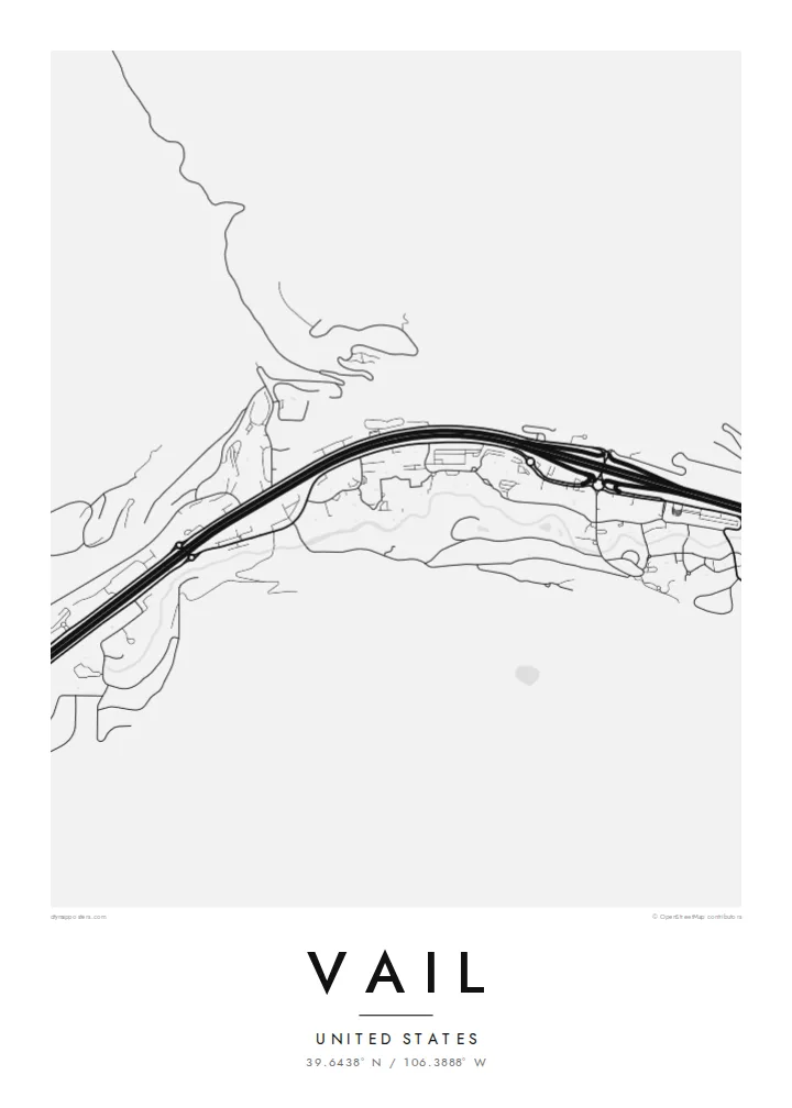
The creek runs the length of town beside Interstate 70, and the two lines together set the east-west grain of the whole map, from the Vail Pass approach down toward West Vail.
Tabula geographica minimalis · United States
39.6438° N / 106.3888° W
A long, narrow town pulled east to west along Gore Creek and the interstate, the ski mountain rising to its south.


Una urbs, quinque animi
Tange formam ut eam in pariete videas. Omnis forma eodem pretio constat — typis impressa, compagine inclusa, vel ut fasciculi HD.
 Pixelli veri · fasciculus impressionis 24 × 36″
Ad imprimendum acuta
Haec est particula 100% fasciculi impressionis veri. Omnis tabula — typis impressa, compagine inclusa, vel demissa — in servis nostris ad 300 DPI conficitur, usque ad 7,200 × 10,800 pixellos, ut etiam angustissimae viae in impressione 24 × 36″ nitidae maneant.
In pariete


Tabula
From above, Vail barely has a width. The town follows the floor of the Gore Creek valley for several miles, squeezed between steep slopes, with Interstate 70 running the full length of it. Frontage roads, roundabouts and the thin line of the creek all run in parallel, so the map reads as a set of stretched bands rather than a grid, broken only where the village cores cluster at the base of the lifts.
Vail opened as a ski area in 1962 on what had been grazing land, founded by a group that included Pete Seibert, a veteran of the 10th Mountain Division, which trained at nearby Camp Hale during the Second World War. The pedestrian lanes of Vail Village were laid out with Alpine towns in mind, and they still show up on the map as a knot of short, curving streets among the straight valley lines.
A Vail map poster keeps that contrast legible: the dense little villages of Vail Village and Lionshead, the long parallel ribbons of road and water, and the empty space where the mountain climbs toward the Back Bowls. It is a quiet, graphic picture of a place most people remember in terms of snow and light, redrawn as lines on paper.
The creek runs the length of town beside Interstate 70, and the two lines together set the east-west grain of the whole map, from the Vail Pass approach down toward West Vail.
The original village core is a tight cluster of short, bending pedestrian streets and a covered bridge over Gore Creek, noticeably finer in texture than anything else in the valley.
South of the ridge the mountain opens into wide, treeless bowls. On a street map they appear as open ground, a calm counterweight to the busy valley floor below.
Tuam fac
Adde diem, nomen vel versum tuum; muta stilum, magnitudinem vel directionem.
Specimen gratuitum resolutionis humilis est cum nota aquatica. Impressiones et fasciculi HD ad 300 DPI conficiuntur, usque ad 7,200 × 10,800 px, sine nota aquatica.
Cur Vail
For many people Vail is tied to a specific week: a first trip, an annual family tradition, a season spent working the lifts. A map of the valley brings that back without resorting to a photo, and it sits comfortably in a hallway, a cabin or a city apartment far from the mountains.
You can set your own title and subtitle, adjust the coordinates line to mark a lodge or a year, and choose from five styles: Classic black & white, Noir, Paper, Blueprint or Sand. Download the HD files for $9 or order a matte print, framed in wood if you like.
Eme tabulam Vail| Magnitudo impressionis | Resolutio | Fasciculi |
|---|---|---|
| 30 × 40 cm (11.8 × 15.7″) | 3,543 × 4,724 px | PNG · PDF |
| 29.7 × 42 cm (A3, 11.7 × 16.5″) | 3,508 × 4,961 px | PNG · PDF |
| 42 × 59.4 cm (A2, 16.5 × 23.4″) | 4,961 × 7,016 px | PNG · PDF |
| 45.7 × 61 cm (18 × 24″) | 5,400 × 7,200 px | PNG · PDF |
| 50 × 70 cm (19.7 × 27.6″) | 5,906 × 8,268 px | PNG · PDF |
| 61 × 91.4 cm (24 × 36″) | 7,200 × 10,800 px | PNG · PDF |
Comparationis causa, specimen gratuitum 900 px latum est, signo aquatico notatum et ad spectandum in quadris lucidis destinatum. Fasciculi HD usque ad octiens maiorem resolutionem in utramque partem habent et tota tabulae magnitudine pure imprimuntur.
Elige formam in summa pagina, deinde selige Tabulam Typis Impressam — magnitudinem et, si vis, compagem — vel Fasciculos Digitales HD. Emptio uno gradu conficitur, et pagina emptionis tuae statim renovatur ubi primum solutio confecta est.
In charta opaca praestanti 200 gsm typis imprimitur, una ex sex magnitudinibus, a 30 × 40 cm usque ad 24 × 36″. Tabulae typis impressae incipiunt a {printFrom}, missione inclusa.
Ita. Elige compagem ex solido ligno, colore nigro, albo, quercu naturali vel ligno obscuro. Vitro infrangibili instructa venit et ad suspendendum parata est. Tabulae compagine inclusae incipiunt a {framedFrom}, missione inclusa.
Missio ubique terrarum gratuita est. Quaeque tabula a proximo nostrorum sociorum impressionis in plus quam 30 nationibus imprimitur et plerumque intra 3–7 dies operis pervenit. Statum et vestigationem sub Emptionibus Meis sequi potes.
Mitte nobis imaginem intra 14 dies post missionem acceptam, et eam gratis iterum imprimemus vel pecuniam tibi reddemus.
Ita. In instrumento huius paginae, titulum, subtitulum et lineam coordinatarum ad libitum muta, et formam ac magnitudinem elige. Emptiones typis impressae, compagine inclusae et digitales omnes exacte figuram tuam adhibent.
Pro $9 accipis fasciculos PNG 300 DPI et PDF ad imprimendum paratos in omnibus sex magnitudinibus, sine nota aquatica, ut ubique imprimere possis. Nondum certus es? Prius specimen gratuitum cum nota aquatica demitte.
