The Una River
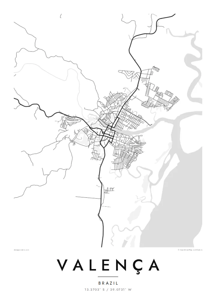
The river runs straight through the town and is its main organising line on the map, with streets and blocks lining both banks and bridges stitching the two halves together.
Tabula geographica minimalis · Brazil
13.3703° S / 39.0731° W
A river town on the Una estuary, its streets following both banks before mangrove channels open toward the Atlantic coast of Bahia


Una urbs, quinque animi
Tange formam ut eam in pariete videas. Omnis forma eodem pretio constat — typis impressa, compagine inclusa, vel ut fasciculi HD.
 Pixelli veri · fasciculus impressionis 24 × 36″
Ad imprimendum acuta
Haec est particula 100% fasciculi impressionis veri. Omnis tabula — typis impressa, compagine inclusa, vel demissa — in servis nostris ad 300 DPI conficitur, usque ad 7,200 × 10,800 pixellos, ut etiam angustissimae viae in impressione 24 × 36″ nitidae maneant.
In pariete


Tabula
Valença sits on the Una River a short way inland from the Bahian coast, and from above the river decides everything. The town spreads along both banks, joined by bridges, with the older core close to the water and newer neighbourhoods climbing the low hills behind. Downstream, the channel widens into an estuary edged with mangroves, where solid land gives way to a loose pattern of creeks and islands.
This layout has long made Valença a place of arrival and departure. Boats leave its waterfront for the islands of the Tinharé archipelago, including Morro de São Paulo and Boipeba, and the town has a long tradition of building wooden boats by hand. In the nineteenth century it also became home to one of Brazil's early textile mills, which drew on the river for its power.
A Valença map poster turns this river geography into a clear graphic. The Una draws a strong line through the composition, the street grid gathers tightly around it, and the estuary to the east breaks into fine, irregular shapes. In black and white, the contrast between the dense town and the open water reads especially well, giving the print both structure and a sense of the coast just beyond it.
The river runs straight through the town and is its main organising line on the map, with streets and blocks lining both banks and bridges stitching the two halves together.
East of the centre, the river widens and splits into channels among mangroves, so the plain outline of the land dissolves into delicate, branching water shapes toward the sea.
The waterfront is a departure point for boats to the Tinharé archipelago, including Morro de São Paulo and Boipeba, which ties the town's plan closely to the water.
Tuam fac
Adde diem, nomen vel versum tuum; muta stilum, magnitudinem vel directionem.
Specimen gratuitum resolutionis humilis est cum nota aquatica. Impressiones et fasciculi HD ad 300 DPI conficiuntur, usque ad 7,200 × 10,800 px, sine nota aquatica.
Cur Valença
For people who grew up in Valença, or who passed through on the way to the islands, this map holds a particular route: the river, the quay, the streets leading down to the boats. It is a quiet reminder of a place defined by water and travel.
Each poster can be personalised with your own title, subtitle and coordinates line, perhaps a family name or the date of a trip. Choose from five styles, Classic black & white, Noir, Paper, Blueprint or Sand, to suit the room where it will hang.
Eme tabulam Valença| Magnitudo impressionis | Resolutio | Fasciculi |
|---|---|---|
| 30 × 40 cm (11.8 × 15.7″) | 3,543 × 4,724 px | PNG · PDF |
| 29.7 × 42 cm (A3, 11.7 × 16.5″) | 3,508 × 4,961 px | PNG · PDF |
| 42 × 59.4 cm (A2, 16.5 × 23.4″) | 4,961 × 7,016 px | PNG · PDF |
| 45.7 × 61 cm (18 × 24″) | 5,400 × 7,200 px | PNG · PDF |
| 50 × 70 cm (19.7 × 27.6″) | 5,906 × 8,268 px | PNG · PDF |
| 61 × 91.4 cm (24 × 36″) | 7,200 × 10,800 px | PNG · PDF |
Comparationis causa, specimen gratuitum 900 px latum est, signo aquatico notatum et ad spectandum in quadris lucidis destinatum. Fasciculi HD usque ad octiens maiorem resolutionem in utramque partem habent et tota tabulae magnitudine pure imprimuntur.
Elige formam in summa pagina, deinde selige Tabulam Typis Impressam — magnitudinem et, si vis, compagem — vel Fasciculos Digitales HD. Emptio uno gradu conficitur, et pagina emptionis tuae statim renovatur ubi primum solutio confecta est.
In charta opaca praestanti 200 gsm typis imprimitur, una ex sex magnitudinibus, a 30 × 40 cm usque ad 24 × 36″. Tabulae typis impressae incipiunt a {printFrom}, missione inclusa.
Ita. Elige compagem ex solido ligno, colore nigro, albo, quercu naturali vel ligno obscuro. Vitro infrangibili instructa venit et ad suspendendum parata est. Tabulae compagine inclusae incipiunt a {framedFrom}, missione inclusa.
Missio ubique terrarum gratuita est. Quaeque tabula a proximo nostrorum sociorum impressionis in plus quam 30 nationibus imprimitur et plerumque intra 3–7 dies operis pervenit. Statum et vestigationem sub Emptionibus Meis sequi potes.
Mitte nobis imaginem intra 14 dies post missionem acceptam, et eam gratis iterum imprimemus vel pecuniam tibi reddemus.
Ita. In instrumento huius paginae, titulum, subtitulum et lineam coordinatarum ad libitum muta, et formam ac magnitudinem elige. Emptiones typis impressae, compagine inclusae et digitales omnes exacte figuram tuam adhibent.
Pro $9 accipis fasciculos PNG 300 DPI et PDF ad imprimendum paratos in omnibus sex magnitudinibus, sine nota aquatica, ut ubique imprimere possis. Nondum certus es? Prius specimen gratuitum cum nota aquatica demitte.
