Mikuma River
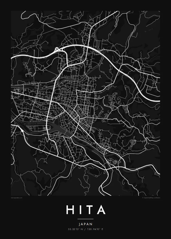
The Mikuma River curves through the heart of the basin, gathering smaller tributaries and dividing the town into districts, the strongest line on the entire map.
Minimalistesche Kaarteposter · Japan
33.3213° N / 130.9410° E
A mountain basin town gathered around the Mikuma River, its Edo-era merchant streets set among forested Kyushu hills.



Eng Stad, fënnef Stëmmungen
Tipp op e Stil fir en un der Wand ze gesinn. All Stil kascht d'selwecht — gedréckt, geframt oder als HD-Dateien.
 Richteg Pixel · 24 × 36″ Print-Datei
Gestach schaarf
Dëst ass en 100%-Ausschnitt vun der richteger Print-Datei. All Poster — gedréckt, geframt oder erofgeluede — gëtt op eise Serveren mat 300 DPI gerendert, bis zu 7,200 × 10,800 Pixel, sou datt och déi klengst Stroossen op engem 24 × 36″-Print scharf bleiwen.
un der Mauer


D'Kaart
Hita occupies a basin in the west of Oita Prefecture, enclosed by forested mountains on every side. Several rivers flow into the basin and join to form the Mikuma River, which runs through the town before continuing toward the Ariake Sea as the Chikugo River. On the map the rivers are the main event, bending through the urban area and dividing it into a series of distinct districts.
During the Edo period Hita was a directly governed territory of the Tokugawa shogunate, and its merchants grew prosperous. The Mamedamachi district preserves their streets, a compact grid of old warehouses and shops that appears on the poster as a finely drawn cluster. Nearby stood Kangien, the private academy founded by the scholar Hirose Tansō, which drew students from across Japan.
Along the Mikuma River, hot spring inns line the banks, and in summer the river is known for traditional cormorant fishing from wooden boats. Around the town, cedar forests cover the slopes that close in the basin. A Hita map poster places the old town, the river and the mountains in a single, balanced frame.
The Mikuma River curves through the heart of the basin, gathering smaller tributaries and dividing the town into districts, the strongest line on the entire map.
The preserved merchant district of Mamedamachi forms a small, dense grid of historic streets, a finely detailed cluster that recalls Hita's Edo-period wealth.
Forested slopes rise on all sides of the basin, and the roads that climb out of town follow the valleys in long winding lines toward the edges.
Maacht en zu Ärem eegenen
Setzt en Datum, en Numm oder eng eegen Zeil derbäi, wiesselt Stil, Gréisst oder Orientéierung.
D'gratis Preview ass a niddereger Opléisung mat enger Waassermark. Prints an HD-Dateien gi mat 300 DPI gerendert, bis zu 7,200 × 10,800 px, ouni Waassermark.
Firwat Hita
Hita rewards a close look, much like its old streets reward a slow walk, and a map of the town suits anyone who has stayed by the river or grown up among its hills. The basin shape makes a naturally framed composition.
Paper and Sand bring out the warmth of the old town, while Noir and Blueprint give the rivers a sharper edge, and Classic black & white keeps it simple. Personalise the title, subtitle and coordinates, then download six print sizes for $9.
Bestell den Hita-Poster| Drockgréisst | Opléisung | Dateien |
|---|---|---|
| 30 × 40 cm11.8 × 15.7″ | 3,543 × 4,724 px | PNG · PDF |
| 29.7 × 42 cm (A3)11.7 × 16.5″ | 3,508 × 4,961 px | PNG · PDF |
| 42 × 59.4 cm (A2)16.5 × 23.4″ | 4,961 × 7,016 px | PNG · PDF |
| 45.7 × 61 cm18 × 24″ | 5,400 × 7,200 px | PNG · PDF |
| 50 × 70 cm19.7 × 27.6″ | 5,906 × 8,268 px | PNG · PDF |
| 61 × 91.4 cm24 × 36″ | 7,200 × 10,800 px | PNG · PDF |
Zum Verglach: Déi gratis Virschau ass 900 px breet, huet e Waasserzeechen an ass fir de Bildschierm geduecht. D'HD-Dateien hunn a jiddwer Richtung bis zu 8× d'Opléisung a loossen sech och a voller Postergréisst propper drécken.
Wiel e Stil uewen op der Säit aus, duerno entscheed dech fir Gedréckte Poster — eng Gréisst a, wann s de wëlls, e Kader — oder Digital HD-Dateien. D'Keess ass an engem Schrëtt gemaach, an deng Bestellungssäit gëtt aktualiséiert soubal d'Bezuelung duerch ass.
Hie gëtt op héichwäertegt mattes 200-g/m²-Pabeier gedréckt, an enger vu sechs Gréissten, vun 30 × 40 cm bis 24 × 36″. Gedréckte Poster fänken bei $39 un, Liwwerung inklusiv.
Jo. Wiel e Kader aus massivem Holz a schwaarz, wäiss, natierlecher Eech oder donkelem Holz. Hien huet eng bruchsécher Verglasung a ka sou opgehaange ginn. Geframte Poster fänken bei $99 un, Liwwerung inklusiv.
De Versand ass weltwäit gratis. All Poster gëtt vum nootste vun eise Dréckpartner an 30+ Länner gedréckt a kënnt normalerweis bannent 3–7 Wochendeeg un. De Status an d'Tracking fënns du ënner Meng Bestellungen. A puer Länner brauchen 2–5 Woche, a wou mir nach net liwweren, seet dir de Site dat, ier du bezuels.
Schéck eis bannent 14 Deeg no der Liwwerung e Foto, a mir drécken en gratis nach eng Kéier oder erstatten dir de Präis.
Jo. Am Editor op dëser Säit kanns de den Titel, den Ënnertitel an d'Koordinatenzeil op alles änneren, wat s de wëlls, a e Stil an eng Gréisst auswielen. Gedréckt, geframt a digital Bestellungen benotzen alleguer genau däi Design.
Fir $9 kriss de 300 DPI PNG- an drockprett PDF-Dateien a all sechs Gréissten, ouni Waassermarken, fir iwwerall ze drécken. Nach net sécher? Lued fir d'éischt eng gratis Preview mat Waassermark erof.
An der Géigend
