River confluence
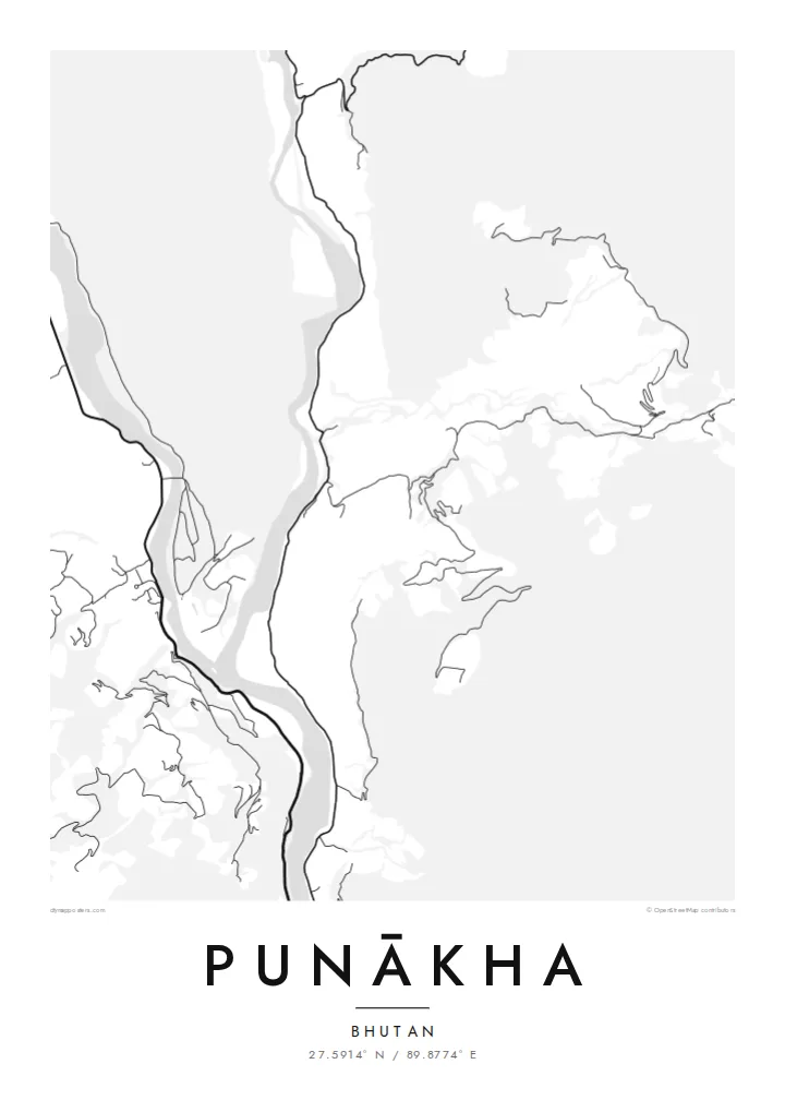
The Pho Chhu and Mo Chhu, often called the father and mother rivers, join just below the dzong and continue down the valley as a single, wider channel.
ໂປສເຕີແຜນທີ່ແບບມິນິມອລ · ພູຖານ
27.5914° N / 89.8774° E
Two glacial rivers meeting on a warm valley floor, with a fortress set on the point of land where they join.


ເມືອງດຽວ, ຫ້າບັນຍາກາດ
ແຕະເລືອກສະໄຕລ໌ເພື່ອເບິ່ງຢູ່ເທິງຝາ. ທຸກສະໄຕລ໌ລາຄາເທົ່າກັນ — ພິມ, ໃສ່ກອບ ຫຼື ເປັນໄຟລ໌ HD.
 ພິກເຊວຈິງ · ໄຟລ໌ພິມ 24 × 36″
ຄົມຊັດພ້ອມພິມ
ນີ້ແມ່ນພາບຕັດ 100% ຈາກໄຟລ໌ພິມຕົວຈິງ. ໂປສເຕີທຸກໃບ — ພິມ, ໃສ່ກອບ ຫຼື ດາວໂຫຼດ — ຖືກສ້າງຢູ່ເຊີບເວີຂອງພວກເຮົາທີ່ 300 DPI, ສູງເຖິງ 7,200 × 10,800 ພິກເຊວ, ດັ່ງນັ້ນເສັ້ນທາງນ້ອຍທີ່ສຸດກໍ່ຍັງຄົມຊັດເມື່ອພິມຂະໜາດ 24 × 36″.
ຢູ່ເທິງຝາ


ແຜນທີ່
Punākha sits low for Bhutan, in a broad valley at around 1,200 metres where the Pho Chhu and the Mo Chhu flow together. From above, the two rivers make up most of the picture: pale ribbons braiding across gravel bars, then merging into one channel that heads south. Roads keep to the valley sides, and houses gather on the few flat terraces the slopes allow.
On the narrow spit between the rivers stands Punākha Dzong. This fortress-monastery was the seat of government while Punākha served as Bhutan's capital, a role it held until the 1950s, and it is still the winter residence of the country's central monastic body. On the map the dzong is a compact block pressed against the water, reached by a covered bridge across the Mo Chhu.
A Punākha map poster keeps that geography plain. There is no dense grid to fill the frame, so the rivers, the valley road and the scattered lanes of the modern town carry the drawing. The result is quieter than most city maps and closer to a landscape study, with the confluence as its natural centre of gravity.
The Pho Chhu and Mo Chhu, often called the father and mother rivers, join just below the dzong and continue down the valley as a single, wider channel.
The fortress fills the tip of land between the two rivers. Its position makes it one of the most recognisable shapes on any map of the valley.
Near the dzong, a long pedestrian suspension bridge crosses the Pho Chhu. It is a thin, taut line on the map linking the paths and villages on either bank.
ເຮັດໃຫ້ເປັນຂອງທ່ານ
ເພີ່ມວັນທີ, ຊື່ ຫຼື ຂໍ້ຄວາມຂອງທ່ານເອງ, ປ່ຽນສະໄຕລ໌, ຂະໜາດ ຫຼື ທິດທາງ.
ຕົວຢ່າງຟຣີມີຄວາມລະອຽດຕ່ຳ ແລະ ມີລາຍນ້ຳ. ໂປສເຕີພິມ ແລະ ໄຟລ໌ HD ຖືກສ້າງທີ່ 300 DPI, ສູງເຖິງ 7,200 × 10,800 px, ບໍ່ມີລາຍນ້ຳ.
ເປັນຫຍັງຕ້ອງ Punākha
People who have walked or travelled through western Bhutan often want something that recalls the whole valley rather than a single photograph. A map of Punākha does this with line alone: two rivers, one fortress and a road following the water. It suits a study, a hallway or any corner where detail can be read slowly.
You can set your own title and subtitle, and replace the coordinates line with a date or a note about the journey. There are five styles: Classic black & white, Noir, Paper, Blueprint and Sand. Paper and Sand suit the softer valley light. Download the HD files for $9 or order a matte print, framed or unframed.
ສັ່ງໂປສເຕີ Punākha| ຂະໜາດພິມ | ຄວາມລະອຽດ | ໄຟລ໌ |
|---|---|---|
| 30 × 40 cm11.8 × 15.7″ | 3,543 × 4,724 px | PNG · PDF |
| 29.7 × 42 cm (A3)11.7 × 16.5″ | 3,508 × 4,961 px | PNG · PDF |
| 42 × 59.4 cm (A2)16.5 × 23.4″ | 4,961 × 7,016 px | PNG · PDF |
| 45.7 × 61 cm18 × 24″ | 5,400 × 7,200 px | PNG · PDF |
| 50 × 70 cm19.7 × 27.6″ | 5,906 × 8,268 px | PNG · PDF |
| 61 × 91.4 cm24 × 36″ | 7,200 × 10,800 px | PNG · PDF |
ເພື່ອປຽບທຽບ, ຕົວຢ່າງຟຣີກວ້າງ 900 px, ມີລາຍນ້ຳ ແລະ ເໝາະສຳລັບໜ້າຈໍ. ໄຟລ໌ HD ມີຄວາມລະອຽດສູງກວ່າເຖິງ 8 ເທົ່າໃນແຕ່ລະດ້ານ ແລະ ພິມອອກມາຄົມຊັດເຕັມຂະໜາດໂປສເຕີ.
ເລືອກສະໄຕລ໌ຢູ່ເທິງສຸດຂອງໜ້າ ຈາກນັ້ນເລືອກ Printed Poster — ຂະໜາດ ແລະ ຖ້າຕ້ອງການ ກອບຮູບ — ຫຼື Digital HD Files. ການຊຳລະເງິນມີພຽງຂັ້ນຕອນດຽວ ແລະ ໜ້າຄຳສັ່ງຊື້ຂອງທ່ານຈະອັບເດດທັນທີທີ່ຊຳລະເງິນສຳເລັດ.
ພິມໃສ່ເຈ້ຍດ້ານພຣີມຽມ 200 gsm ໃນໜຶ່ງໃນຫົກຂະໜາດ, ຈາກ 30 × 40 cm ຫາ 24 × 36″. ໂປສເຕີພິມເລີ່ມຕົ້ນທີ່ $39, ລວມຄ່າສົ່ງ.
ໄດ້. ເລືອກກອບໄມ້ແທ້ສີດຳ, ສີຂາວ, ໄມ້ໂອກທຳມະຊາດ ຫຼື ໄມ້ສີເຂັ້ມ. ມາພ້ອມກະຈົກກັນແຕກ ແລະ ພ້ອມແຂວນໄດ້ທັນທີ. ໂປສເຕີໃສ່ກອບເລີ່ມຕົ້ນທີ່ $99, ລວມຄ່າສົ່ງ.
ຈັດສົ່ງຟຣີໄປ 60+ ປະເທດ. ໂປສເຕີແຕ່ລະອັນຖືກພິມໂດຍຄູ່ຮ່ວມງານພິມທີ່ຢູ່ໃກ້ທີ່ສຸດໃນ 30+ ປະເທດ ແລະ ປົກກະຕິຈະຮອດພາຍໃນ 3–7 ວັນທຳການ. ທ່ານສາມາດຕິດຕາມສະຖານະ ແລະ ເລກພັດສະດຸໄດ້ທີ່ ຄຳສັ່ງຊື້ຂອງຂ້ອຍ. ບາງປະເທດໃຊ້ເວລາ 2–5 ອາທິດ, ແລະ ຖ້າປະເທດໃດທີ່ເຮົາຍັງບໍ່ໄດ້ຈັດສົ່ງໄປ, ເວັບໄຊຈະແຈ້ງໃຫ້ທ່ານຮູ້ກ່ອນຊຳລະເງິນ.
ສົ່ງຮູບຖ່າຍໃຫ້ພວກເຮົາພາຍໃນ 14 ວັນຫຼັງໄດ້ຮັບສິນຄ້າ ແລ້ວພວກເຮົາຈະພິມໃຫ້ໃໝ່ຟຣີ ຫຼື ຄືນເງິນໃຫ້ທ່ານ.
ໄດ້. ໃນຕົວແກ້ໄຂຢູ່ໜ້ານີ້ ປ່ຽນຫົວຂໍ້, ຫົວຂໍ້ຍ່ອຍ ແລະ ແຖວພິກັດເປັນຫຍັງກໍ່ໄດ້ຕາມໃຈມັກ ແລ້ວເລືອກສະໄຕລ໌ ແລະ ຂະໜາດ. ຄຳສັ່ງຊື້ແບບພິມ, ໃສ່ກອບ ແລະ ດິຈິຕອລ ຈະໃຊ້ດີໄຊນ໌ຂອງທ່ານທັງໝົດ.
ໃນລາຄາ $9 ທ່ານຈະໄດ້ຮັບໄຟລ໌ PNG ແລະ PDF ພ້ອມພິມທີ່ 300 DPI ໃນທັງຫົກຂະໜາດ, ບໍ່ມີລາຍນ້ຳ, ພິມທີ່ໃດກໍ່ໄດ້. ຍັງບໍ່ແນ່ໃຈບໍ? ດາວໂຫຼດຕົວຢ່າງທີ່ມີລາຍນ້ຳຟຣີກ່ອນ.
