Suomenlinna sea fortress
Built in the eighteenth century across several linked islands at the harbour entrance, its angular bastions and irregular walls form one of the most distinctive outlines on the whole map.
Minimalistinis žemėlapio plakatas · Suomija
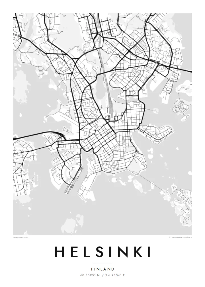
60.1695° N / 24.9354° E
A granite peninsula that breaks into bays and islands, with a compact grid at its tip and sea on three sides


Vienas miestas, penkios nuotaikos
Palieskite stilių, kad pamatytumėte jį ant sienos. Visi stiliai kainuoja vienodai — spausdinti, įrėminti ar kaip HD failai.
 Tikri pikseliai · 24 × 36″ spaudinio failas
Ryškus spaudai
Tai 100% tikro spaudinio failo iškarpa. Kiekvienas plakatas — spausdintas, įrėmintas ar atsisiųstas — sukuriamas mūsų serveriuose 300 DPI raiška, iki 7,200 × 10,800 pikselių, todėl net mažiausios gatvelės išlieka ryškios 24 × 36″ spaudinyje.
Ant sienos


Žemėlapis
Helsinki sits on a peninsula that pushes into the Gulf of Finland, and from above its coastline matters most. The land breaks into coves, headlands and more than three hundred islands, so the city carries on past the point where the streets stop. Inland the pattern loosens into leafy districts and a long strip of forest, the Central Park, which runs north almost unbroken from Töölö Bay towards the city's edge.
The centre is orderly. After Helsinki was named capital in 1812, the architect Carl Ludvig Engel laid out a neoclassical core around Senate Square. The Esplanadi park strip still runs west from the market harbour as straight as a ruler. Around it, blocks of stone apartment buildings form a tight grid that reads cleanly in black and white. Rail yards and the long curve of the harbour break it up.
A Helsinki map poster shows this balance of order and irregularity: a precise centre, a coastline with almost no straight lines, and water in every gap. Offshore, the island fortress of Suomenlinna, a UNESCO World Heritage Site, spreads across a cluster of connected islets at the harbour mouth. Ferries, bridges and causeways join the rest together, and each one leaves a thin line on the page.
Built in the eighteenth century across several linked islands at the harbour entrance, its angular bastions and irregular walls form one of the most distinctive outlines on the whole map.
Senate Square and the Esplanadi park avenue sit just back from the South Harbour. They give the densest streets a clear, symmetrical anchor that stands out at every print size.
A band of forest about ten kilometres long runs north from the inner city. It leaves a wide, pale ribbon between the residential districts on either side.
Sukurkite savo
Pridėkite datą, vardą ar savo žodžius, keiskite stilių, dydį ar orientaciją.
Nemokama peržiūra yra mažos raiškos ir su vandens ženklu. Spaudiniai ir HD failai kuriami 300 DPI raiška, iki 7,200 × 10,800 px, be vandens ženklo.
Kodėl Helsinki
People hang Helsinki for a flat near Töölö, summers on the islands, or an exchange year that turned into something longer. The map holds all of it at once: the harbour, the grid and the sea. Add a title, a date or a line of coordinates to mark which chapter it belongs to.
The coastline works especially well in Noir, where the water turns dark and the islands look like scattered light, or in Blueprint for a cooler, technical look. Classic black & white, Paper and Sand are available too. Download the HD files for $9 or order a matte print, framed if you like.
Užsisakyti Helsinki plakatą| Spaudinio dydis | Raiška | Failai |
|---|---|---|
| 30 × 40 cm (11.8 × 15.7″) | 3,543 × 4,724 px | PNG · PDF |
| 29.7 × 42 cm (A3, 11.7 × 16.5″) | 3,508 × 4,961 px | PNG · PDF |
| 42 × 59.4 cm (A2, 16.5 × 23.4″) | 4,961 × 7,016 px | PNG · PDF |
| 45.7 × 61 cm (18 × 24″) | 5,400 × 7,200 px | PNG · PDF |
| 50 × 70 cm (19.7 × 27.6″) | 5,906 × 8,268 px | PNG · PDF |
| 61 × 91.4 cm (24 × 36″) | 7,200 × 10,800 px | PNG · PDF |
Palyginimui: nemokama peržiūra yra 900 px pločio, su vandens ženklu ir skirta ekranams. HD failų raiška kiekviena kryptimi iki 8 kartų didesnė, todėl jie puikiai spausdinami viso plakato dydžiu.
Pasirinkite stilių puslapio viršuje, tada pasirinkite Spausdintą plakatą — dydį ir, jei norite, rėmelį — arba Skaitmeninius HD failus. Užsakymas atliekamas vienu žingsniu, o jūsų užsakymo puslapis atsinaujina iš karto, kai tik įvyksta apmokėjimas.
Jis spausdinamas ant aukščiausios kokybės 200 g/m² matinio popieriaus vienu iš šešių dydžių, nuo 30 × 40 cm iki 24 × 36″. Spausdintų plakatų kaina prasideda nuo $39, pristatymas įskaičiuotas.
Taip. Pasirinkite masyvaus medžio rėmelį juodos, baltos, natūralaus ąžuolo ar tamsaus medžio spalvos. Jis komplektuojamas su atspariu dūžiams stiklu ir paruoštas kabinti iš karto. Įrėmintų plakatų kaina prasideda nuo $99, pristatymas įskaičiuotas.
Pristatymas visame pasaulyje nemokamas. Kiekvieną plakatą atspausdina arčiausiai jūsų esantis spaustuvės partneris iš daugiau nei 30 šalių, o atkeliauja paprastai per 3–7 darbo dienas. Būseną ir siuntos sekimą rasite skiltyje „Mano užsakymai“. Kai kuriose šalyse pristatymas trunka 2–5 savaites, o jei dar nesiunčiame į jūsų šalį, svetainė apie tai praneš prieš apmokant.
Atsiųskite mums nuotrauką per 14 dienų nuo pristatymo, ir mes nemokamai perspausdinsime plakatą arba grąžinsime pinigus.
Taip. Šio puslapio redaktoriuje pakeiskite pavadinimą, paantraštę ir koordinačių eilutę pagal savo norą bei pasirinkite stilių ir dydį. Spausdinti, įrėminti ir skaitmeniniai užsakymai naudos būtent jūsų sukurtą dizainą.
Už $9 gaunate 300 DPI PNG ir spaudai paruoštus PDF failus visais šešiais dydžiais, be vandens ženklo, kad galėtumėte spausdinti bet kur. Dar neapsisprendėte? Pirmiausia atsisiųskite nemokamą peržiūrą su vandens ženklu.
Netoliese
