Penn's five squares
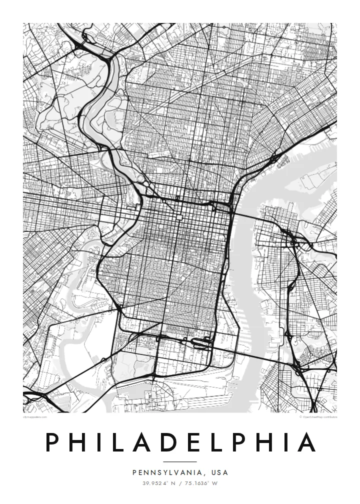
City Hall at the centre and four squares placed symmetrically around it are still visible as open spaces in the grid, a direct trace of the 1682 plan.
Minimalistinis žemėlapio plakatas · Jungtinės Valstijos
39.9524° N / 75.1636° W
William Penn's orderly grid between two rivers, anchored by City Hall and cut by a single diagonal parkway.


Vienas miestas, penkios nuotaikos
Palieskite stilių, kad pamatytumėte jį ant sienos. Visi stiliai kainuoja vienodai — spausdinti, įrėminti ar kaip HD failai.
 Tikri pikseliai · 24 × 36″ spaudinio failas
Ryškus spaudai
Tai 100% tikro spaudinio failo iškarpa. Kiekvienas plakatas — spausdintas, įrėmintas ar atsisiųstas — sukuriamas mūsų serveriuose 300 DPI raiška, iki 7,200 × 10,800 pikselių, todėl net mažiausios gatvelės išlieka ryškios 24 × 36″ spaudinyje.
Ant sienos


Žemėlapis
Philadelphia began as one of the first planned cities in America. In 1682 William Penn and his surveyor Thomas Holme laid out a rectangular grid stretching between the Delaware River on the east and the Schuylkill on the west, with five public squares placed at regular points. That plan still governs Center City, and it is easy to trace on a map today.
Broad Street and Market Street cross at the central square, where City Hall now stands, and four smaller squares, Rittenhouse, Washington, Logan and Franklin, sit in each quadrant. Near the Delaware, Independence Hall marks where the Declaration of Independence and the Constitution were debated and signed. Beyond the original grid, later neighbourhoods tilt and bend to follow old roads and the rivers.
The Benjamin Franklin Parkway breaks the pattern with a deliberate diagonal from City Hall to the Philadelphia Museum of Art, beyond which Fairmount Park follows the Schuylkill and the Wissahickon Creek for miles. A Philadelphia map poster frames all of this: the strict grid, the two rivers and the green valleys winding out toward the northwest.
City Hall at the centre and four squares placed symmetrically around it are still visible as open spaces in the grid, a direct trace of the 1682 plan.
The only major diagonal in Center City runs northwest from City Hall to the art museum, a wide boulevard modelled on Parisian avenues.
One of the largest urban park systems in the country follows the Schuylkill and Wissahickon Creek, drawing long green corridors through the northwestern neighbourhoods.
Sukurkite savo
Pridėkite datą, vardą ar savo žodžius, keiskite stilių, dydį ar orientaciją.
Nemokama peržiūra yra mažos raiškos ir su vandens ženklu. Spaudiniai ir HD failai kuriami 300 DPI raiška, iki 7,200 × 10,800 px, be vandens ženklo.
Kodėl Philadelphia
Philadelphians tend to identify strongly with their neighbourhood, whether that is Fishtown, South Philly, Germantown or Rittenhouse. A map of the city lets you show the whole grid while pointing to one corner of it, a first apartment, a rowhouse or the place you met someone.
Personalise the title, the subtitle and the coordinates line with a street, a name or a date. Choose Classic black & white, Noir, Paper, Blueprint or Sand. Printed posters ship from partners in more than 30 countries, with an optional wooden frame.
Užsisakyti Philadelphia plakatą| Spaudinio dydis | Raiška | Failai |
|---|---|---|
| 30 × 40 cm11.8 × 15.7″ | 3,543 × 4,724 px | PNG · PDF |
| 29.7 × 42 cm (A3)11.7 × 16.5″ | 3,508 × 4,961 px | PNG · PDF |
| 42 × 59.4 cm (A2)16.5 × 23.4″ | 4,961 × 7,016 px | PNG · PDF |
| 45.7 × 61 cm18 × 24″ | 5,400 × 7,200 px | PNG · PDF |
| 50 × 70 cm19.7 × 27.6″ | 5,906 × 8,268 px | PNG · PDF |
| 61 × 91.4 cm24 × 36″ | 7,200 × 10,800 px | PNG · PDF |
Palyginimui: nemokama peržiūra yra 900 px pločio, su vandens ženklu ir skirta ekranams. HD failų raiška kiekviena kryptimi iki 8 kartų didesnė, todėl jie puikiai spausdinami viso plakato dydžiu.
Pasirinkite stilių puslapio viršuje, tada pasirinkite Spausdintą plakatą — dydį ir, jei norite, rėmelį — arba Skaitmeninius HD failus. Užsakymas atliekamas vienu žingsniu, o jūsų užsakymo puslapis atsinaujina iš karto, kai tik įvyksta apmokėjimas.
Jis spausdinamas ant aukščiausios kokybės 200 g/m² matinio popieriaus vienu iš šešių dydžių, nuo 30 × 40 cm iki 24 × 36″. Spausdintų plakatų kaina prasideda nuo $39, pristatymas įskaičiuotas.
Taip. Pasirinkite masyvaus medžio rėmelį juodos, baltos, natūralaus ąžuolo ar tamsaus medžio spalvos. Jis komplektuojamas su atspariu dūžiams stiklu ir paruoštas kabinti iš karto. Įrėmintų plakatų kaina prasideda nuo $99, pristatymas įskaičiuotas.
Pristatymas nemokamas į 60+ šalių. Kiekvieną plakatą atspausdina artimiausias iš mūsų spaudos partnerių 30+ šalių, o pristatoma paprastai per 3–7 darbo dienas. Būseną ir siuntos sekimą rasite skiltyje „Mano užsakymai“. Į kai kurias šalis siunta keliauja 2–5 savaites, o jei dar nesiunčiame į jūsų šalį, svetainė apie tai praneša prieš apmokėjimą.
Atsiųskite mums nuotrauką per 14 dienų nuo pristatymo, ir mes nemokamai perspausdinsime plakatą arba grąžinsime pinigus.
Taip. Šio puslapio redaktoriuje pakeiskite pavadinimą, paantraštę ir koordinačių eilutę pagal savo norą bei pasirinkite stilių ir dydį. Spausdinti, įrėminti ir skaitmeniniai užsakymai naudos būtent jūsų sukurtą dizainą.
Už $9 gaunate 300 DPI PNG ir spaudai paruoštus PDF failus visais šešiais dydžiais, be vandens ženklo, kad galėtumėte spausdinti bet kur. Dar neapsisprendėte? Pirmiausia atsisiųskite nemokamą peržiūrą su vandens ženklu.
Netoliese
