Transport interchange
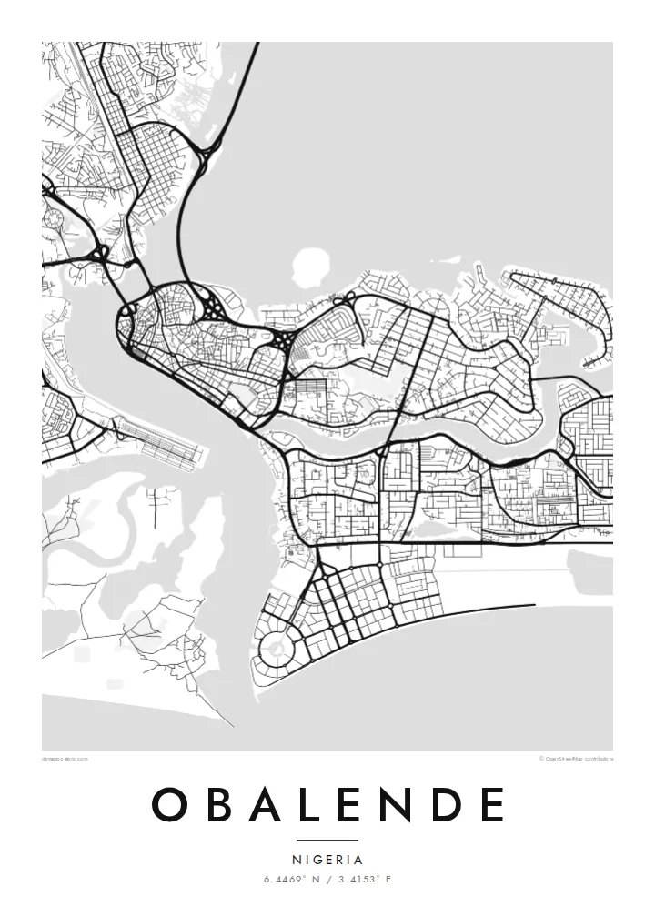
Roads converge on Obalende from several directions, forming loops and junctions that serve one of the busiest bus and commuter hubs in Lagos.
Minimalistyczny plakat z mapą · Nigeria
6.4469° N / 3.4153° E
A transit district on the eastern side of Lagos Island, framed by lagoon water, bridge approaches and the leafy streets of Ikoyi.


Jedno miasto, pięć nastrojów
Dotknij stylu, aby zobaczyć go na ścianie. Każdy styl kosztuje tyle samo — jako druk, w ramie lub pliki HD.
 Rzeczywiste piksele · plik do druku 24 × 36″
Ostrość do druku
To jest wycinek w skali 100% z prawdziwego pliku do druku. Każdy plakat — drukowany, oprawiony lub pobrany — jest renderowany na naszych serwerach w rozdzielczości 300 DPI, do 7,200 × 10,800 pikseli, dzięki czemu nawet najmniejsze ulice pozostają ostre na wydruku 24 × 36″.
Na ścianie


Mapa
Obalende sits where Lagos Island meets Ikoyi, and on a map it looks like a hinge between two very different street patterns. To the west lie the tight, irregular lanes of the old island centre; to the east, the wider, curving roads of Ikoyi. Obalende itself is dense and busy, organised around roads that feed traffic toward the bridges and the mainland.
The area is best known as one of the city's major transport hubs, where buses, minibuses and motorcycles gather before heading across the lagoon or along the islands. That role is visible from above in the way roads converge, split and loop around interchanges, creating a knot of lines that stands out against the finer grain of nearby residential blocks.
An Obalende map poster captures a small area with an outsized role in daily Lagos life. Framed closely, it shows the meeting of island, lagoon and highway; framed wider, it places the district within the watery geography of Lagos Island and Ikoyi. Either way, the black and white rendering turns a noisy junction into a calm study of movement.
Roads converge on Obalende from several directions, forming loops and junctions that serve one of the busiest bus and commuter hubs in Lagos.
The district marks the transition from the dense, irregular lanes of Lagos Island to the broader, curving residential roads of Ikoyi, a contrast clear at any scale.
Water frames the wider view on several sides, with lagoon channels and bridge approaches giving the map strong, clean boundaries around the built-up land.
Spersonalizuj
Dodaj datę, imię lub własny tekst, zmień styl, rozmiar lub orientację.
Darmowy podgląd ma niską rozdzielczość i znak wodny. Wydruki i pliki HD są renderowane w 300 DPI, do 7,200 × 10,800 px, bez znaku wodnego.
Dlaczego Obalende
For anyone who has commuted through Lagos, Obalende is a familiar point on the daily route, a place of departures and arrivals. A map of it is a small tribute to those journeys and to the island geography that shapes the whole city.
Set your own title, subtitle and coordinates line, and choose between Classic black and white, Noir, Paper, Blueprint and Sand. Files come as 300 DPI PNG and print-ready PDF in six sizes for $9, or order a matte printed poster shipped from a partner near you.
Zamów plakat Obalende| Rozmiar wydruku | Rozdzielczość | Pliki |
|---|---|---|
| 30 × 40 cm (11.8 × 15.7″) | 3,543 × 4,724 px | PNG · PDF |
| 29.7 × 42 cm (A3, 11.7 × 16.5″) | 3,508 × 4,961 px | PNG · PDF |
| 42 × 59.4 cm (A2, 16.5 × 23.4″) | 4,961 × 7,016 px | PNG · PDF |
| 45.7 × 61 cm (18 × 24″) | 5,400 × 7,200 px | PNG · PDF |
| 50 × 70 cm (19.7 × 27.6″) | 5,906 × 8,268 px | PNG · PDF |
| 61 × 91.4 cm (24 × 36″) | 7,200 × 10,800 px | PNG · PDF |
Dla porównania: darmowy podgląd ma 900 px szerokości, znak wodny i jest przeznaczony na ekran. Pliki HD mają do 8× wyższą rozdzielczość w każdym kierunku i drukują się wyraźnie w pełnym rozmiarze plakatu.
Wybierz styl na górze strony, a następnie wybierz Plakat drukowany — rozmiar i opcjonalnie ramę — albo Pliki cyfrowe HD. Płatność zajmuje jeden krok, a strona zamówienia aktualizuje się od razu po jej zaksięgowaniu.
Jest drukowany na papierze matowym premium 200 g/m² w jednym z sześciu rozmiarów, od 30 × 40 cm do 24 × 36″. Drukowane plakaty zaczynają się od {printFrom}, z darmową wysyłką.
Tak. Wybierz ramę z litego drewna w kolorze czarnym, białym, naturalnego dębu lub ciemnego drewna. Zawiera nietłukące szkło i jest gotowa do powieszenia. Plakaty w ramach zaczynają się od {framedFrom}, z darmową wysyłką.
Wysyłka jest darmowa na całym świecie. Każdy plakat drukuje najbliższy z naszych partnerów drukarskich w ponad 30 krajach i zwykle dociera w 3–7 dni roboczych. Status i numer przesyłki znajdziesz w Moich zamówieniach.
Wyślij nam zdjęcie w ciągu 14 dni od dostawy, a bezpłatnie wydrukujemy go ponownie lub zwrócimy pieniądze.
Tak. W edytorze na tej stronie zmień tytuł, podtytuł i linię ze współrzędnymi na dowolne, po czym wybierz styl i rozmiar. Zamówienia drukowane, w ramie i cyfrowe zawsze odzwierciedlają dokładnie Twój projekt.
Za $9 otrzymujesz pliki PNG w 300 DPI oraz PDF gotowe do druku, we wszystkich sześciu rozmiarach, bez znaku wodnego, do wydruku w dowolnym miejscu. Nie masz pewności? Najpierw pobierz darmowy podgląd ze znakiem wodnym.
W pobliżu
