The Mahakali River
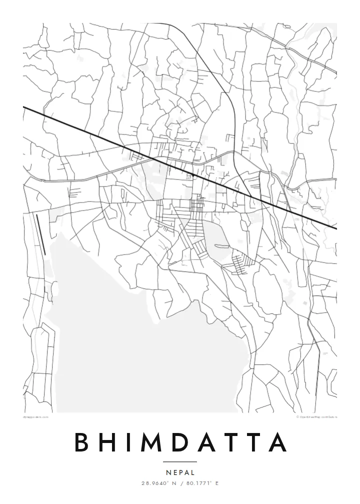
The broad braided river along the western edge forms the international border. Its channels and sandbars give the map a loose, shifting edge instead of a hard line.
Ipositeri y'ikarita yoroheje · NP
28.9640° N / 80.1771° E
A flat Terai town at Nepal's far-western edge, set between the Mahakali River, forest reserves and the first ridges of hills.


Umujyi umwe, imiterere itanu
Kanda uburyo bumwe kugira ngo ubibone ku rukuta. Buri buryo bufite igiciro kimwe — cyacapwe, gishyizwemo cadre cyangwa mu madosiye HD.
 Pikiseli nyakuri · Dosiye yo gucapa ya 24 × 36″
Bisobanutse neza iyo bicapwe
Iki ni igice cya 100% cy'idosiye nyayo yo gucapa. Buri poster — yacapwe, ishyizwemo cadre cyangwa yakuwe kuri interineti — ikorwa kuri seriveri zacu ku 300 DPI, kugeza kuri pikiseli 7,200 × 10,800, bityo n'imihanda mito cyane igumana ubwiza ku gucapa kwa 24 × 36″.
Ku rukuta


Ikarita
Bhimdatta, long known as Mahendranagar, is the main town of Kanchanpur District in Sudurpashchim Pradesh, in the far west of Nepal. It sits on the level plain of the Terai, close to the border with India. The flat ground shows on a map. Streets spread across open land without the switchbacks of hill towns, and the edges run out into fields, irrigation channels and patches of forest.
The Mahakali River, which marks this stretch of the border between Nepal and India, runs just west of the town. It sets the western limit of the map. Across it is the Indian town of Banbasa, and the crossing between them is one of the busiest in western Nepal. To the south lies Shuklaphanta National Park, a wide area of grassland and forest that appears on a Bhimdatta map poster as a large, quiet space.
The town was renamed in honour of Bhimdatta Panta, a twentieth-century activist remembered for his campaigns for farmers' rights in the far west. It is also near the western end of the Mahendra Highway, the east–west route that crosses the country's lowland belt. That road ties Bhimdatta to the rest of Nepal, so the town reads as a western terminus as well as a border town.
The broad braided river along the western edge forms the international border. Its channels and sandbars give the map a loose, shifting edge instead of a hard line.
The national park south of town is a large expanse of grassland and forest with almost no streets. On the poster it becomes a calm open area next to the urban blocks.
The Mahendra Highway reaches this corner of the country after crossing the lowlands from the east. On the map it is the long straight line that anchors the town.
Yigire iyawe
Ongeraho itariki, izina cyangwa interuro yawe, uhindure imiterere, ingano cyangwa icyerekezo.
Urugero rw'ubuntu rufite ubwiza buke kandi rufite ikimenyetso cy'amazi. Poster zacapwe n'amadosiye ya HD bikorwa ku 300 DPI, kugeza kuri 7,200 × 10,800 px, nta kimenyetso cy'amazi.
Kuki Bhimdatta
For people from Kanchanpur, or those who have crossed the border here or travelled Nepal's lowland highway to its western end, this map marks a real point of arrival. The flat plain, the river and the reserve make a clear, balanced composition on a wall.
You can edit the title, subtitle and coordinates, for example to use Mahendranagar, the older name, or a date that matters to you. Then pick one of five styles: Classic black and white, Noir, Paper, Blueprint or Sand.
Tumiza poster ya Bhimdatta| Ingano yo gucapa | Ubwiza bw'ifoto | Amadosiye |
|---|---|---|
| 30 × 40 cm11.8 × 15.7″ | 3,543 × 4,724 px | PNG · PDF |
| 29.7 × 42 cm (A3)11.7 × 16.5″ | 3,508 × 4,961 px | PNG · PDF |
| 42 × 59.4 cm (A2)16.5 × 23.4″ | 4,961 × 7,016 px | PNG · PDF |
| 45.7 × 61 cm18 × 24″ | 5,400 × 7,200 px | PNG · PDF |
| 50 × 70 cm19.7 × 27.6″ | 5,906 × 8,268 px | PNG · PDF |
| 61 × 91.4 cm24 × 36″ | 7,200 × 10,800 px | PNG · PDF |
Ugereranyije, igerageza ry'ubuntu rifite ubugari bwa 900 px, ririho ikirango kandi ryagenewe kurebwa kuri ecran. Amadosiye ya HD afite ubwiza bugera kuri 8× kuri buri ruhande kandi acapwa neza ku ngano yuzuye y'ipositeri.
Hitamo uburyo hejuru y'urupapuro, hanyuma uhitemo Poster Yacapwe — ingano n'niba ubishaka, cadre — cyangwa Amadosiye ya Digital HD. Kwishyura bikorwa mu ntambwe imwe, kandi urupapuro rw'ikurikirana ry'ibyo watumije ruvugururwa vuba nyuma yo kwishyura.
Icapwa ku rupapuro rwa mbere rwa 200 gsm rutagaragaza umucyo, mu ngano imwe muri esheshatu, kuva kuri 30 × 40 cm kugeza kuri 24 × 36″. Poster zacapwe zitangirira kuri $39, harimo no kohereza.
Yego. Hitamo cadre y'igiti gikomeye mu ibara ry'umukara, umweru, oak isanzwe cyangwa igiti cyijimye. Iza n'ikirahure kidacika kandi yiteguye kumanikwa. Poster zifite cadre zitangirira kuri $99, harimo no kohereza.
Kohereza ni ubuntu mu bihugu 60+. Buri cyapa gicapirwa n'umufatanyabikorwa wacu wa hafi mu bihugu 30+ dukorana mu gucapa, kandi gisanzwe kigera mu minsi y'akazi 3–7. Ushobora gukurikirana uko giteye n'aho kigeze muri «Ibyo naguze». Ibihugu bimwe bifata ibyumweru 2–5, kandi aho tutarahagera, urubuga rukubwira mbere y'uko wishyura.
Twoherereze ifoto mu minsi 14 ikurikira igihe cyo kuyakira, kandi tuzayicapa bundi bushya ku buntu cyangwa tukagusubiza amafaranga.
Yego. Muri editor iri kuri uru rupapuro, hindura umutwe, ikirongo cy'inyongera n'umurongo w'ibipimo ukagira icyo ushaka, hanyuma ugahitamo uburyo n'ingano. Amatumizo yacapwe, afite cadre n'aya digital yose akoresha ishushanyo ryawe nk'uko ryifashe.
Ku $9 ubona amadosiye ya PNG ya 300 DPI n'aya PDF yiteguye gucapwa mu ngano zose esheshatu, nta kimenyetso cy'amazi, ushobora gucapa aho ariho hose. Ntucyemeje? Banza umanure urugero rw'ubuntu rufite ikimenyetso cy'amazi.
Hafi aho
