Euripus Strait
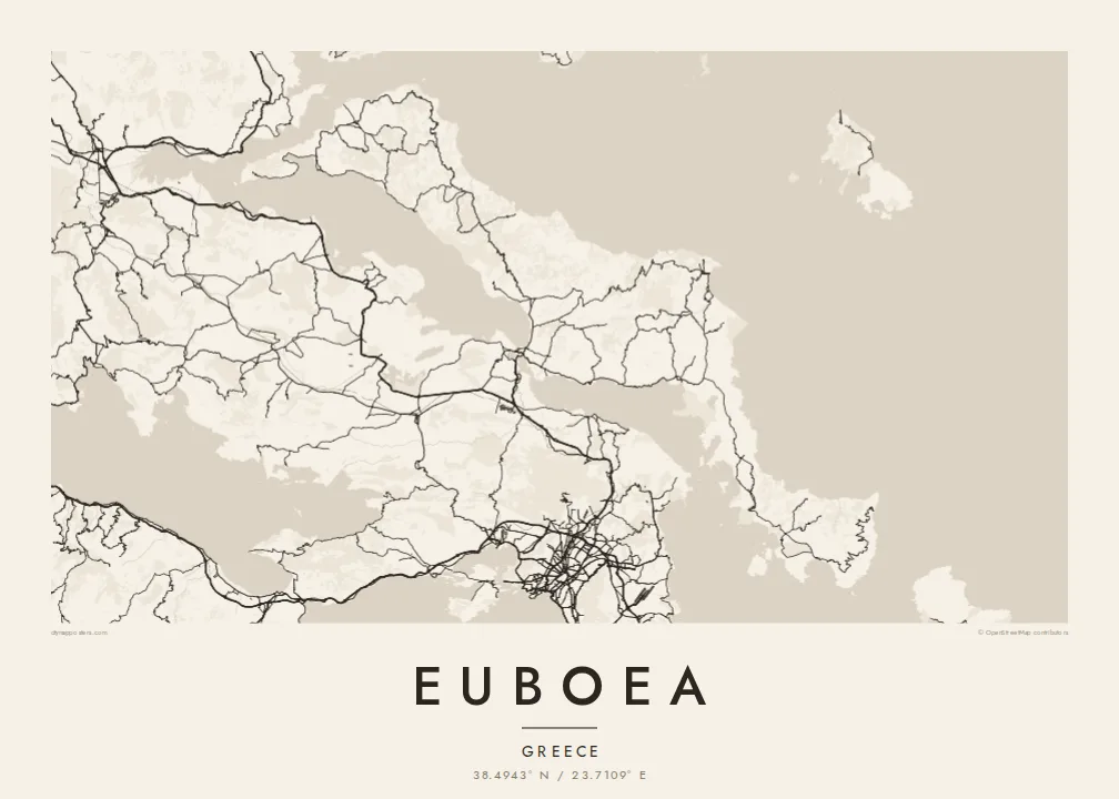
At Chalkida the channel between the island and the mainland narrows to a few dozen metres, and two bridges cross it. This tiny gap in the coastline defines the whole map.
Ipositeri y'ikarita yoroheje · GR
38.4943° N / 23.7109° E
A long, narrow island lying parallel to the Greek mainland, joined to it by bridges across a strait only metres wide




Umujyi umwe, imiterere itanu
Kanda uburyo bumwe kugira ngo ubibone ku rukuta. Buri buryo bufite igiciro kimwe — cyacapwe, gishyizwemo cadre cyangwa mu madosiye HD.
 Pikiseli nyakuri · Dosiye yo gucapa ya 24 × 36″
Bisobanutse neza iyo bicapwe
Iki ni igice cya 100% cy'idosiye nyayo yo gucapa. Buri poster — yacapwe, ishyizwemo cadre cyangwa yakuwe kuri interineti — ikorwa kuri seriveri zacu ku 300 DPI, kugeza kuri pikiseli 7,200 × 10,800, bityo n'imihanda mito cyane igumana ubwiza ku gucapa kwa 24 × 36″.
Ku rukuta


Ikarita
Euboea is the second-largest island in Greece after Crete. It stretches for well over a hundred kilometres along the mainland coast northeast of Athens. On a map it is long, narrow and mountainous, and its axis mirrors the shape of the coast opposite. The North and South Euboean Gulfs lie between the two shores and almost close up at Chalkida, near the island's midpoint.
Chalkida, the largest town, sits at the narrowest point of the strait, the Euripus, where two bridges link the island to the mainland. The currents in the channel are well known: they change direction several times a day and have puzzled writers since ancient times. The town's streets fan out from the waterfront, and the mainland shore is only a short distance away.
The north of the island has long been known for its pine forests. The centre rises to the high peak of Dirfys, and the south narrows into a dry, rugged peninsula that ends near Karystos. Villages and small ports line both coasts, linked by roads that wind through the mountains. A Euboea map poster shows an island that feels almost part of the mainland, divided from it by a thread of sea.
At Chalkida the channel between the island and the mainland narrows to a few dozen metres, and two bridges cross it. This tiny gap in the coastline defines the whole map.
The island's highest mountain rises in central Euboea and gathers the contour lines tightly. Small roads climb to villages on its slopes and drop down to the east coast.
South of its midpoint, Euboea narrows into a long, mountainous arm that reaches toward Andros. It ends in a coast of small bays around Karystos.
Yigire iyawe
Ongeraho itariki, izina cyangwa interuro yawe, uhindure imiterere, ingano cyangwa icyerekezo.
Urugero rw'ubuntu rufite ubwiza buke kandi rufite ikimenyetso cy'amazi. Poster zacapwe n'amadosiye ya HD bikorwa ku 300 DPI, kugeza kuri 7,200 × 10,800 px, nta kimenyetso cy'amazi.
Kuki Euboea
For many Athenians, Euboea is a place of summer homes and family villages, and it is a quieter alternative to the better-known islands. Its long profile and the fine thread of the Euripus make it a striking shape on the wall.
You can write your own title and subtitle, perhaps naming a village or a year, and adjust the coordinates line. Choose from Classic black and white, Noir, Paper, Blueprint and Sand, then order a printed poster or download the HD files for $9.
Tumiza poster ya Euboea| Ingano yo gucapa | Ubwiza bw'ifoto | Amadosiye |
|---|---|---|
| 30 × 40 cm (11.8 × 15.7″) | 3,543 × 4,724 px | PNG · PDF |
| 29.7 × 42 cm (A3, 11.7 × 16.5″) | 3,508 × 4,961 px | PNG · PDF |
| 42 × 59.4 cm (A2, 16.5 × 23.4″) | 4,961 × 7,016 px | PNG · PDF |
| 45.7 × 61 cm (18 × 24″) | 5,400 × 7,200 px | PNG · PDF |
| 50 × 70 cm (19.7 × 27.6″) | 5,906 × 8,268 px | PNG · PDF |
| 61 × 91.4 cm (24 × 36″) | 7,200 × 10,800 px | PNG · PDF |
Ugereranyije, igerageza ry'ubuntu rifite ubugari bwa 900 px, ririho ikirango kandi ryagenewe kurebwa kuri ecran. Amadosiye ya HD afite ubwiza bugera kuri 8× kuri buri ruhande kandi acapwa neza ku ngano yuzuye y'ipositeri.
Hitamo uburyo hejuru y'urupapuro, hanyuma uhitemo Poster Yacapwe — ingano n'niba ubishaka, cadre — cyangwa Amadosiye ya Digital HD. Kwishyura bikorwa mu ntambwe imwe, kandi urupapuro rw'ikurikirana ry'ibyo watumije ruvugururwa vuba nyuma yo kwishyura.
Icapwa ku rupapuro rwa mbere rwa 200 gsm rutagaragaza umucyo, mu ngano imwe muri esheshatu, kuva kuri 30 × 40 cm kugeza kuri 24 × 36″. Poster zacapwe zitangirira kuri $39, harimo no kohereza.
Yego. Hitamo cadre y'igiti gikomeye mu ibara ry'umukara, umweru, oak isanzwe cyangwa igiti cyijimye. Iza n'ikirahure kidacika kandi yiteguye kumanikwa. Poster zifite cadre zitangirira kuri $99, harimo no kohereza.
Kohereza ni ubuntu ku isi hose. Buri paje icapwa n'umwe mu bafatanyabikorwa bacu mu gucapa ukwegereye, mu bihugu birenga 30, kandi akenshi igera ku muguzi mu minsi 3–7 y'akazi. Ushobora gukurikirana uko iteye n'aho igeze muri "Ibyo naguze". Ibihugu bimwe bifata ibyumweru 2–5, naho aho tutarohereza, urubuga ruzakubwira mbere y'uko wishyura.
Twoherereze ifoto mu minsi 14 ikurikira igihe cyo kuyakira, kandi tuzayicapa bundi bushya ku buntu cyangwa tukagusubiza amafaranga.
Yego. Muri editor iri kuri uru rupapuro, hindura umutwe, ikirongo cy'inyongera n'umurongo w'ibipimo ukagira icyo ushaka, hanyuma ugahitamo uburyo n'ingano. Amatumizo yacapwe, afite cadre n'aya digital yose akoresha ishushanyo ryawe nk'uko ryifashe.
Ku $9 ubona amadosiye ya PNG ya 300 DPI n'aya PDF yiteguye gucapwa mu ngano zose esheshatu, nta kimenyetso cy'amazi, ushobora gucapa aho ariho hose. Ntucyemeje? Banza umanure urugero rw'ubuntu rufite ikimenyetso cy'amazi.
Hafi aho
