Agrovila grids
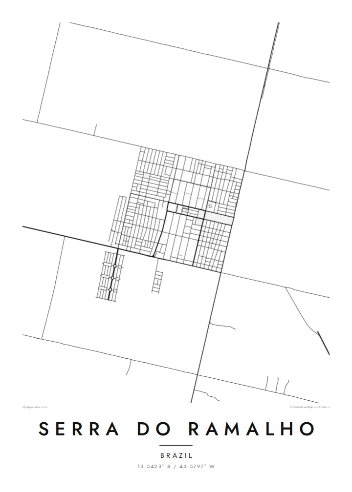
Small planned villages appear as compact rectangles of streets, repeated across the municipality and clearly different from the organic layouts of older Brazilian towns.
Ipositeri y'ikarita yoroheje · BR
13.5423° S / 43.5797° W
A planned rural municipality in western Bahia, where numbered agricultural villages sit in grids across open land west of the São Francisco.


Umujyi umwe, imiterere itanu
Kanda uburyo bumwe kugira ngo ubibone ku rukuta. Buri buryo bufite igiciro kimwe — cyacapwe, gishyizwemo cadre cyangwa mu madosiye HD.
 Pikiseli nyakuri · Dosiye yo gucapa ya 24 × 36″
Bisobanutse neza iyo bicapwe
Iki ni igice cya 100% cy'idosiye nyayo yo gucapa. Buri poster — yacapwe, ishyizwemo cadre cyangwa yakuwe kuri interineti — ikorwa kuri seriveri zacu ku 300 DPI, kugeza kuri pikiseli 7,200 × 10,800, bityo n'imihanda mito cyane igumana ubwiza ku gucapa kwa 24 × 36″.
Ku rukuta


Ikarita
Serra do Ramalho lies in the west of Bahia, near the São Francisco River. It was established as a planned settlement project in the 1970s, largely for families relocated when the Sobradinho reservoir flooded towns and farmland upstream. Its origins as a planned community are visible on the map: a series of small, regularly laid out villages rather than a single urban centre.
These villages, known as agrovilas, were designed with simple grids of streets surrounded by agricultural land. A Serra do Ramalho map poster shows them as neat clusters of blocks spaced across a wider landscape of fields, dirt roads and dry vegetation, connected to one another by long straight routes.
The river valley and the broad interior of Bahia give the area a sense of scale that is hard to capture in photographs. On the map, the contrast between the tidy grids of the settlements and the open land around them reveals a landscape that was deliberately organised, and a community that grew from a specific moment in the region's history.
Small planned villages appear as compact rectangles of streets, repeated across the municipality and clearly different from the organic layouts of older Brazilian towns.
Long, straight roads link the villages across open land, forming a network that shows how the settlement project was organised from the start.
The river and its wide valley lie close by, giving the region its agricultural base and defining the broader landscape in which the settlements sit.
Yigire iyawe
Ongeraho itariki, izina cyangwa interuro yawe, uhindure imiterere, ingano cyangwa icyerekezo.
Urugero rw'ubuntu rufite ubwiza buke kandi rufite ikimenyetso cy'amazi. Poster zacapwe n'amadosiye ya HD bikorwa ku 300 DPI, kugeza kuri 7,200 × 10,800 px, nta kimenyetso cy'amazi.
Kuki Serra do Ramalho
Families shaped by the resettlement along the São Francisco often hold a strong connection to the places they rebuilt. A map of Serra do Ramalho, with its numbered villages, records that story through the land itself.
The title and subtitle can name a specific agrovila, a family or a date, in Portuguese or English. Blueprint highlights the planned layout, while Sand reflects the dry interior landscape of western Bahia.
Tumiza poster ya Serra do Ramalho| Ingano yo gucapa | Ubwiza bw'ifoto | Amadosiye |
|---|---|---|
| 30 × 40 cm11.8 × 15.7″ | 3,543 × 4,724 px | PNG · PDF |
| 29.7 × 42 cm (A3)11.7 × 16.5″ | 3,508 × 4,961 px | PNG · PDF |
| 42 × 59.4 cm (A2)16.5 × 23.4″ | 4,961 × 7,016 px | PNG · PDF |
| 45.7 × 61 cm18 × 24″ | 5,400 × 7,200 px | PNG · PDF |
| 50 × 70 cm19.7 × 27.6″ | 5,906 × 8,268 px | PNG · PDF |
| 61 × 91.4 cm24 × 36″ | 7,200 × 10,800 px | PNG · PDF |
Ugereranyije, igerageza ry'ubuntu rifite ubugari bwa 900 px, ririho ikirango kandi ryagenewe kurebwa kuri ecran. Amadosiye ya HD afite ubwiza bugera kuri 8× kuri buri ruhande kandi acapwa neza ku ngano yuzuye y'ipositeri.
Hitamo uburyo hejuru y'urupapuro, hanyuma uhitemo Poster Yacapwe — ingano n'niba ubishaka, cadre — cyangwa Amadosiye ya Digital HD. Kwishyura bikorwa mu ntambwe imwe, kandi urupapuro rw'ikurikirana ry'ibyo watumije ruvugururwa vuba nyuma yo kwishyura.
Icapwa ku rupapuro rwa mbere rwa 200 gsm rutagaragaza umucyo, mu ngano imwe muri esheshatu, kuva kuri 30 × 40 cm kugeza kuri 24 × 36″. Poster zacapwe zitangirira kuri $39, harimo no kohereza.
Yego. Hitamo cadre y'igiti gikomeye mu ibara ry'umukara, umweru, oak isanzwe cyangwa igiti cyijimye. Iza n'ikirahure kidacika kandi yiteguye kumanikwa. Poster zifite cadre zitangirira kuri $99, harimo no kohereza.
Kohereza ni ubuntu mu bihugu 60+. Buri cyapa gicapirwa n'umufatanyabikorwa wacu wa hafi mu bihugu 30+ dukorana mu gucapa, kandi gisanzwe kigera mu minsi y'akazi 3–7. Ushobora gukurikirana uko giteye n'aho kigeze muri «Ibyo naguze». Ibihugu bimwe bifata ibyumweru 2–5, kandi aho tutarahagera, urubuga rukubwira mbere y'uko wishyura.
Twoherereze ifoto mu minsi 14 ikurikira igihe cyo kuyakira, kandi tuzayicapa bundi bushya ku buntu cyangwa tukagusubiza amafaranga.
Yego. Muri editor iri kuri uru rupapuro, hindura umutwe, ikirongo cy'inyongera n'umurongo w'ibipimo ukagira icyo ushaka, hanyuma ugahitamo uburyo n'ingano. Amatumizo yacapwe, afite cadre n'aya digital yose akoresha ishushanyo ryawe nk'uko ryifashe.
Ku $9 ubona amadosiye ya PNG ya 300 DPI n'aya PDF yiteguye gucapwa mu ngano zose esheshatu, nta kimenyetso cy'amazi, ushobora gucapa aho ariho hose. Ntucyemeje? Banza umanure urugero rw'ubuntu rufite ikimenyetso cy'amazi.
Hafi aho
