Gore Creek corridor
The creek runs the length of town beside Interstate 70, and the two lines together set the east-west grain of the whole map, from the Vail Pass approach down toward West Vail.
Ipositeri y'ikarita yoroheje · US
39.6438° N / 106.3888° W
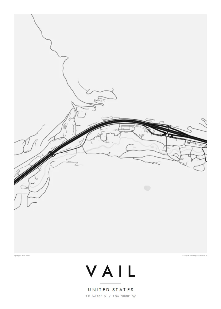
A long, narrow town pulled east to west along Gore Creek and the interstate, the ski mountain rising to its south.


Umujyi umwe, imiterere itanu
Kanda uburyo bumwe kugira ngo ubibone ku rukuta. Buri buryo bufite igiciro kimwe — cyacapwe, gishyizwemo cadre cyangwa mu madosiye HD.
 Pikiseli nyakuri · Dosiye yo gucapa ya 24 × 36″
Bisobanutse neza iyo bicapwe
Iki ni igice cya 100% cy'idosiye nyayo yo gucapa. Buri poster — yacapwe, ishyizwemo cadre cyangwa yakuwe kuri interineti — ikorwa kuri seriveri zacu ku 300 DPI, kugeza kuri pikiseli 7,200 × 10,800, bityo n'imihanda mito cyane igumana ubwiza ku gucapa kwa 24 × 36″.
Ku rukuta


Ikarita
From above, Vail barely has a width. The town follows the floor of the Gore Creek valley for several miles, squeezed between steep slopes, with Interstate 70 running the full length of it. Frontage roads, roundabouts and the thin line of the creek all run in parallel, so the map reads as a set of stretched bands rather than a grid, broken only where the village cores cluster at the base of the lifts.
Vail opened as a ski area in 1962 on what had been grazing land, founded by a group that included Pete Seibert, a veteran of the 10th Mountain Division, which trained at nearby Camp Hale during the Second World War. The pedestrian lanes of Vail Village were laid out with Alpine towns in mind, and they still show up on the map as a knot of short, curving streets among the straight valley lines.
A Vail map poster keeps that contrast legible: the dense little villages of Vail Village and Lionshead, the long parallel ribbons of road and water, and the empty space where the mountain climbs toward the Back Bowls. It is a quiet, graphic picture of a place most people remember in terms of snow and light, redrawn as lines on paper.
The creek runs the length of town beside Interstate 70, and the two lines together set the east-west grain of the whole map, from the Vail Pass approach down toward West Vail.
The original village core is a tight cluster of short, bending pedestrian streets and a covered bridge over Gore Creek, noticeably finer in texture than anything else in the valley.
South of the ridge the mountain opens into wide, treeless bowls. On a street map they appear as open ground, a calm counterweight to the busy valley floor below.
Yigire iyawe
Ongeraho itariki, izina cyangwa interuro yawe, uhindure imiterere, ingano cyangwa icyerekezo.
Urugero rw'ubuntu rufite ubwiza buke kandi rufite ikimenyetso cy'amazi. Poster zacapwe n'amadosiye ya HD bikorwa ku 300 DPI, kugeza kuri 7,200 × 10,800 px, nta kimenyetso cy'amazi.
Kuki Vail
For many people Vail is tied to a specific week: a first trip, an annual family tradition, a season spent working the lifts. A map of the valley brings that back without resorting to a photo, and it sits comfortably in a hallway, a cabin or a city apartment far from the mountains.
You can set your own title and subtitle, adjust the coordinates line to mark a lodge or a year, and choose from five styles: Classic black & white, Noir, Paper, Blueprint or Sand. Download the HD files for $9 or order a matte print, framed in wood if you like.
Tumiza poster ya Vail| Ingano yo gucapa | Ubwiza bw'ifoto | Amadosiye |
|---|---|---|
| 30 × 40 cm (11.8 × 15.7″) | 3,543 × 4,724 px | PNG · PDF |
| 29.7 × 42 cm (A3, 11.7 × 16.5″) | 3,508 × 4,961 px | PNG · PDF |
| 42 × 59.4 cm (A2, 16.5 × 23.4″) | 4,961 × 7,016 px | PNG · PDF |
| 45.7 × 61 cm (18 × 24″) | 5,400 × 7,200 px | PNG · PDF |
| 50 × 70 cm (19.7 × 27.6″) | 5,906 × 8,268 px | PNG · PDF |
| 61 × 91.4 cm (24 × 36″) | 7,200 × 10,800 px | PNG · PDF |
Ugereranyije, igerageza ry'ubuntu rifite ubugari bwa 900 px, ririho ikirango kandi ryagenewe kurebwa kuri ecran. Amadosiye ya HD afite ubwiza bugera kuri 8× kuri buri ruhande kandi acapwa neza ku ngano yuzuye y'ipositeri.
Hitamo uburyo hejuru y'urupapuro, hanyuma uhitemo Poster Yacapwe — ingano n'niba ubishaka, cadre — cyangwa Amadosiye ya Digital HD. Kwishyura bikorwa mu ntambwe imwe, kandi urupapuro rw'ikurikirana ry'ibyo watumije ruvugururwa vuba nyuma yo kwishyura.
Icapwa ku rupapuro rwa mbere rwa 200 gsm rutagaragaza umucyo, mu ngano imwe muri esheshatu, kuva kuri 30 × 40 cm kugeza kuri 24 × 36″. Poster zacapwe zitangirira kuri {printFrom}, harimo no kohereza.
Yego. Hitamo cadre y'igiti gikomeye mu ibara ry'umukara, umweru, oak isanzwe cyangwa igiti cyijimye. Iza n'ikirahure kidacika kandi yiteguye kumanikwa. Poster zifite cadre zitangirira kuri {framedFrom}, harimo no kohereza.
Kohereza ni ubuntu ku isi hose. Buri paje icapwa n'umwe mu bafatanyabikorwa bacu mu gucapa ukwegereye, mu bihugu birenga 30, kandi akenshi igera ku muguzi mu minsi 3–7 y'akazi. Ushobora gukurikirana uko iteye n'aho igeze muri "Ibyo naguze". Ibihugu bimwe bifata ibyumweru 2–5, naho aho tutarohereza, urubuga ruzakubwira mbere y'uko wishyura.
Twoherereze ifoto mu minsi 14 ikurikira igihe cyo kuyakira, kandi tuzayicapa bundi bushya ku buntu cyangwa tukagusubiza amafaranga.
Yego. Muri editor iri kuri uru rupapuro, hindura umutwe, ikirongo cy'inyongera n'umurongo w'ibipimo ukagira icyo ushaka, hanyuma ugahitamo uburyo n'ingano. Amatumizo yacapwe, afite cadre n'aya digital yose akoresha ishushanyo ryawe nk'uko ryifashe.
Ku $9 ubona amadosiye ya PNG ya 300 DPI n'aya PDF yiteguye gucapwa mu ngano zose esheshatu, nta kimenyetso cy'amazi, ushobora gucapa aho ariho hose. Ntucyemeje? Banza umanure urugero rw'ubuntu rufite ikimenyetso cy'amazi.
