Interstate junction
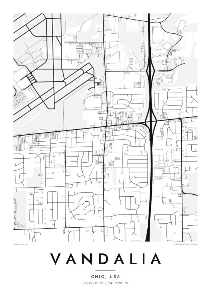
I-70 and I-75 meet near Vandalia, and the interchange loops show up clearly from above. They frame the city with the widest and boldest lines on the print.
සරල සිතියම් පෝස්ටරය · එක්සත් ජනපදය
39.8906° N / 84.1988° W
An Ohio crossroads city north of Dayton, where interstates, the National Road and airport runways meet in a suburban grid


එක් නගරයක්, මනෝභාව පහක්
ශෛලියක් තට්ටු කර එය බිත්තියේ බලන්න. සෑම ශෛලියක්ම එකම මිලට — මුද්රිත, රාමු කළ හෝ HD ගොනු ලෙස.
 සැබෑ පික්සල් · 24 × 36″ මුද්රණ ගොනුව
මුද්රණයට තියුණු
මෙය සැබෑ මුද්රණ ගොනුවේ 100% කැපුමකි. සෑම පෝස්ටරයක්ම — මුද්රිත, රාමු කළ හෝ බාගත කළ — අපගේ සර්වර්වල 300 DPI වලින්, 7,200 × 10,800 පික්සල් දක්වා විදැහුම් කරනු ලැබේ, එමගින් 24 × 36″ මුද්රණයක සිඟුම් වීදිවත් පැහැදිලිව පෙනේ.
බිත්තියේ


සිතියම
Vandalia lies just north of Dayton, Ohio, at a point where major routes come together. Interstate 75 runs north–south along its eastern side, Interstate 70 runs east–west through the area, and the historic National Road, now US 40, passes through the city. The local slogan, Crossroads of America, describes the map quite literally.
Dayton International Airport sits immediately to the west, and its runways form long, crossing lines at the edge of the city. Between the highways, Vandalia's residential streets follow a mostly regular grid with some curving subdivisions. Parks, schools and a compact centre along the old National Road break it up. Farmland still reaches the outer edges.
A Vandalia map poster shows a place defined by movement: interchanges, arterial roads and runways surrounding a quiet, ordinary suburb. In black and white, the heavy highway lines, the fine residential streets and the geometric airfield make one of the more graphic compositions among small Ohio cities.
I-70 and I-75 meet near Vandalia, and the interchange loops show up clearly from above. They frame the city with the widest and boldest lines on the print.
US 40, the historic National Road, runs through Vandalia. It was one of the first major federally built roads in the United States and still forms a central axis of the city.
Dayton International Airport lies just west of the city. Its runways and taxiways create a large geometric shape at the edge of the map.
ඔබේම කරගන්න
දිනයක්, නමක් හෝ ඔබේම වාක්යයක් එක් කරන්න, ශෛලිය, ප්රමාණය හෝ දිශානතිය වෙනස් කරන්න.
නොමිලේ පෙරදසුන අඩු විභේදනයෙන් සහ watermark සමඟින් වේ. මුද්රණ සහ HD ගොනු watermark නොමැතිව, 300 DPI, 7,200 × 10,800 px දක්වා විදැහුම් කරනු ලැබේ.
ඇයි Vandalia
A map of Vandalia suits people from the Dayton area, aviation enthusiasts and anyone whose life has passed through this crossroads. It shows a familiar place with more structure and character than people usually expect.
Title it with your street, family or high school class, add a date, and keep the coordinates. Choose from Classic black & white, Noir, Paper, Blueprint or Sand. Order it printed on matte paper, with or without a wooden frame.
Vandalia පෝස්ටරය ඇණවුම් කරන්න| මුද්රණ ප්රමාණය | විභේදනය | ගොනු |
|---|---|---|
| 30 × 40 cm11.8 × 15.7″ | 3,543 × 4,724 px | PNG · PDF |
| 29.7 × 42 cm (A3)11.7 × 16.5″ | 3,508 × 4,961 px | PNG · PDF |
| 42 × 59.4 cm (A2)16.5 × 23.4″ | 4,961 × 7,016 px | PNG · PDF |
| 45.7 × 61 cm18 × 24″ | 5,400 × 7,200 px | PNG · PDF |
| 50 × 70 cm19.7 × 27.6″ | 5,906 × 8,268 px | PNG · PDF |
| 61 × 91.4 cm24 × 36″ | 7,200 × 10,800 px | PNG · PDF |
සැසඳීම සඳහා, නොමිලේ ලැබෙන පෙරදසුන 900 px පළල, ජල සලකුණු සහිත සහ තිර සඳහා අදහස් කළකි. HD ගොනුවල එක් එක් දිශාවට 8 ගුණයක් දක්වා විභේදනයක් ඇති අතර සම්පූර්ණ පෝස්ටර් ප්රමාණයෙන් පිරිසිදුව මුද්රණය වේ.
පිටුවේ ඉහළින් ශෛලියක් තෝරන්න, පසුව මුද්රිත පෝස්ටරය — ප්රමාණයක් සහ, ඔබ කැමති නම්, රාමුවක් — හෝ Digital HD Files තෝරන්න. ගෙවීම එක් පියවරකින් සිදු වන අතර, ගෙවීම සම්පූර්ණ වූ විගසම ඔබේ ඇණවුම් පිටුව යාවත්කාලීන වේ.
එය 30 × 40 cm සිට 24 × 36″ දක්වා ප්රමාණ හයකින් ප්රිමියම් 200 gsm මැට් කඩදාසි මත මුද්රණය කෙරේ. මුද්රිත පෝස්ටර $39 සිට ආරම්භ වේ, බෙදාහැරීම ඇතුළුව.
ඔව්. කළු, සුදු, ස්වාභාවික ඕක් හෝ තද පැහැති දැව රාමුවක් තෝරන්න. එය කැඩෙන්නට නොහැකි වීදුරුවක් සමඟින් සූදානම්ව එනු ලබන අතර එසැණින් එල්ලීමට හැකිය. රාමු කළ පෝස්ටර $99 සිට ආරම්භ වේ, බෙදාහැරීම ඇතුළුව.
රටවල් 60+ කට බෙදාහැරීම නොමිලේ. සෑම පෝස්ටරයක්ම රටවල් 30+ ක ඇති අපගේ මුද්රණ හවුල්කරුවන්ගෙන් ඔබට ළඟම සිටින අයකු විසින් මුද්රණය කර, සාමාන්යයෙන් වැඩ කරන දින 3–7 ක් ඇතුළත ලැබේ. තත්ත්වය සහ ලුහුබැඳීම My Orders යටතේ බලාගත හැක. සමහර රටවලට සති 2–5 ක් ගත වේ; අපි තවම බෙදාහරින්නේ නැති රටකට නම්, ගෙවීමට පෙර අඩවිය ඒ බව ඔබට දන්වයි.
බෙදාහැරීමෙන් දින 14ක් ඇතුළත අපට ඡායාරූපයක් යවන්න, අපි එය නොමිලේ නැවත මුද්රණය කරන්නෙමු හෝ ඔබට මුදල් ආපසු ලබා දෙන්නෙමු.
ඔව්. මෙම පිටුවේ එඩිටරයේ, මාතෘකාව, උපමාතෘකාව සහ ඛණාංක රේඛාව ඔබට කැමති ඕනෑම දෙයකට වෙනස් කර, ශෛලියක් සහ ප්රමාණයක් තෝරන්න. මුද්රිත, රාමු කළ සහ ඩිජිටල් ඇණවුම් සියල්ලම හරියටම ඔබේ නිර්මාණය භාවිත කරයි.
$9කට ඔබට ප්රමාණ හයම සඳහා 300 DPI PNG සහ මුද්රණයට සූදානම් PDF ගොනු, watermark නොමැතිව, ඕනෑම තැනක මුද්රණය කිරීමට ලැබේ. තවම විශ්වාස නැද්ද? මුලින්ම නොමිලේ watermark සහිත පෙරදසුනක් බාගන්න.
