Museum Island
The northern end of the Spree island holds five major museums between two arms of the river. It is a compact shape, recognizable on any map of Berlin.
Minimalistický mapový plagát · Nemecko
52.5222° N / 13.3977° E
The Spree splits around Museum Island while Unter den Linden draws a straight line west to the Brandenburg Gate.


Jedno mesto, päť nálad
Klepnutím na štýl si ho pozrite na stene. Všetky štýly stoja rovnako — tlačené, zarámované aj ako HD súbory.
 Skutočné pixely · tlačový súbor 24 × 36″
Ostré ako pri tlači
Toto je 100% výrez zo skutočného tlačového súboru. Každý plagát — tlačený, zarámovaný alebo stiahnutý — vykresľujeme na našich serveroch pri 300 DPI, až do 7,200 × 10,800 pixelov, takže aj tie najmenšie uličky zostanú ostré na tlači 24 × 36″.
Na stene


Mapa
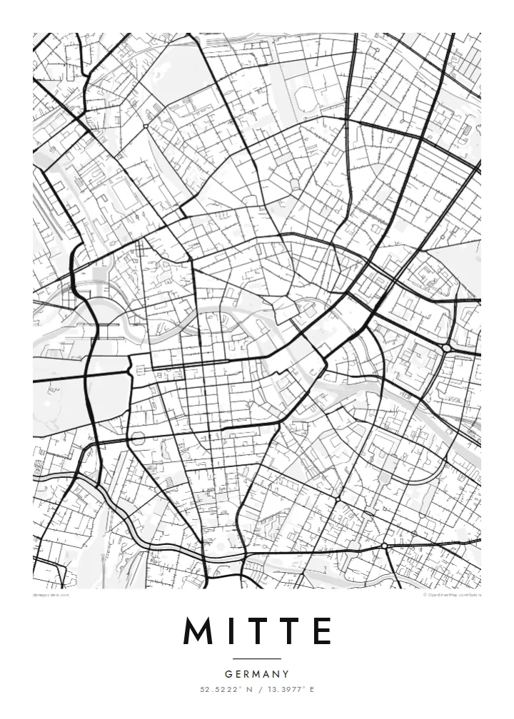
Mitte is Berlin's historic core, and its map is organized around the Spree. The river divides into two arms here, enclosing an island whose northern tip holds Museum Island, a UNESCO World Heritage ensemble of five museums. West of the water, Unter den Linden runs in a broad straight line to the Brandenburg Gate and the Tiergarten. Friedrichstraße crosses it on a long north–south axis.
East of the river, the plan changes. Alexanderplatz opens as a large irregular space beneath the television tower, completed in 1969, and wide postwar boulevards replace the older baroque grid. The Berlin Wall ran along much of Mitte's western and southern edges. You can still trace its former line where newer buildings fill strips that once stood empty.
A Mitte map poster brings these layers together on one sheet: the curving river, the ordered blocks of Friedrichstadt south of Unter den Linden, squares such as Gendarmenmarkt, and the looser plan around Alexanderplatz. The center of the image is dense and opens toward the park on one side, which gives the composition a natural sense of weight.
The northern end of the Spree island holds five major museums between two arms of the river. It is a compact shape, recognizable on any map of Berlin.
A wide tree-lined boulevard runs from the island west to the Brandenburg Gate. It is one of the clearest straight lines in the city.
Within the Friedrichstadt grid, this square framed by two domed churches and a concert hall stands out as a precise open rectangle among regular blocks.
Prispôsobte si ho
Pridajte dátum, meno alebo vlastný text, zmeňte štýl, veľkosť či orientáciu.
Bezplatný náhľad má nízke rozlíšenie a vodoznak. Tlače a HD súbory sa vykresľujú pri 300 DPI, až do 7,200 × 10,800 px, bez vodoznaku.
Prečo Mitte
Mitte is where many visitors first meet Berlin, and where many residents work, study or first settle. Its map carries the city's divided past without spelling it out, which makes it a thoughtful piece for a wall.
You can personalize the title and subtitle with a year or an address, and keep or edit the coordinates. Choose one of five styles. Blueprint suits the river and the grid especially well. Download the files for $9 or order a printed poster.
Objednať plagát Mitte| Veľkosť tlače | Rozlíšenie | Súbory |
|---|---|---|
| 30 × 40 cm (11.8 × 15.7″) | 3,543 × 4,724 px | PNG · PDF |
| 29.7 × 42 cm (A3, 11.7 × 16.5″) | 3,508 × 4,961 px | PNG · PDF |
| 42 × 59.4 cm (A2, 16.5 × 23.4″) | 4,961 × 7,016 px | PNG · PDF |
| 45.7 × 61 cm (18 × 24″) | 5,400 × 7,200 px | PNG · PDF |
| 50 × 70 cm (19.7 × 27.6″) | 5,906 × 8,268 px | PNG · PDF |
| 61 × 91.4 cm (24 × 36″) | 7,200 × 10,800 px | PNG · PDF |
Pre porovnanie: bezplatný náhľad má šírku 900 px, obsahuje vodoznak a je určený na obrazovky. HD súbory majú až 8× vyššie rozlíšenie v každom smere a čisto sa vytlačia aj vo veľkosti plagátu.
Vyberte si štýl v hornej časti stránky a potom zvoľte Tlačený plagát — veľkosť a prípadne rám — alebo Digitálne HD súbory. Objednávka prebehne na jeden krok a stránka objednávky sa aktualizuje hneď po spracovaní platby.
Tlačí sa na prémiový matný papier 200 g/m² v jednej zo šiestich veľkostí, od 30 × 40 cm až po 24 × 36″. Tlačené plagáty začínajú na {printFrom}, doprava v cene.
Áno. Vyberte si rám z masívneho dreva v čiernej, bielej, prírodnej dubovej alebo tmavej farbe. Súčasťou je nerozbitné sklo a je pripravený na zavesenie. Zarámované plagáty začínajú na {framedFrom}, doprava v cene.
Doprava je zdarma po celom svete. Každý plagát vytlačí najbližší z našich tlačových partnerov vo viac ako 30 krajinách a zvyčajne dorazí do 3 – 7 pracovných dní. Stav a sledovanie zásielky nájdete v sekcii Moje objednávky.
Pošlite nám fotografiu do 14 dní od doručenia a my ho zadarmo vytlačíme znova, alebo vám vrátime peniaze.
Áno. V editore na tejto stránke si podľa ľubovôle zmeňte nadpis, podnadpis aj riadok so súradnicami a vyberte štýl a veľkosť. Tlačené, zarámované aj digitálne objednávky použijú presne váš návrh.
Za $9 získate PNG súbory s rozlíšením 300 DPI a tlačovo pripravené PDF súbory vo všetkých šiestich veľkostiach, bez vodoznaku, na tlač kdekoľvek. Ešte si nie ste istí? Najprv si stiahnite bezplatný náhľad s vodoznakom.
