Strait of Magellan
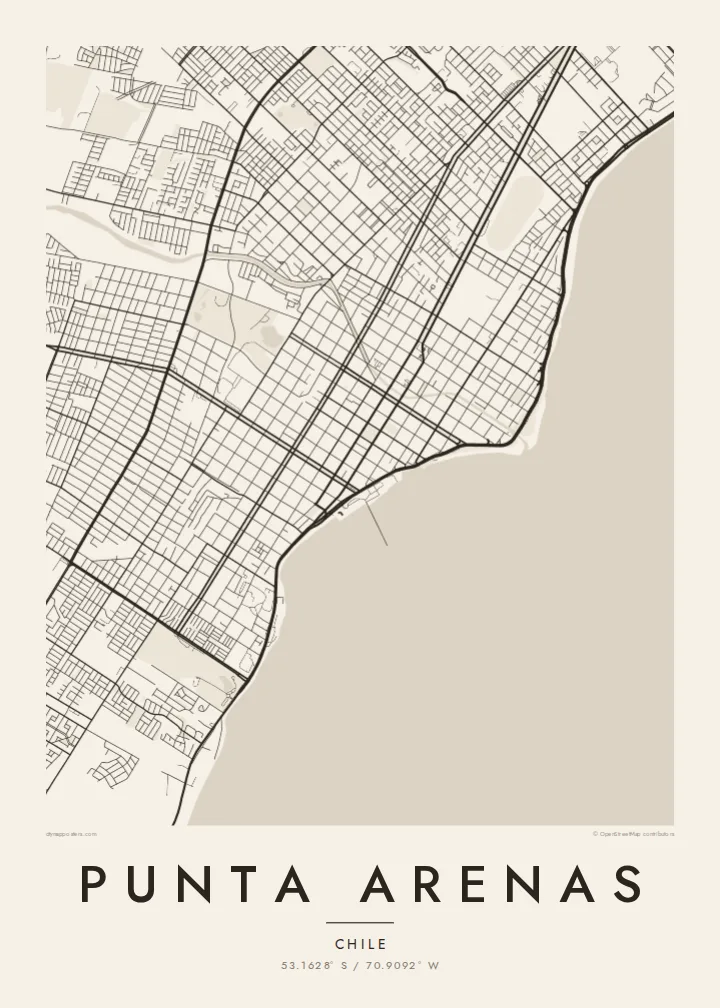
The city's whole eastern side faces the strait. On the poster it appears as a broad open plane, with the city running along one shore and Tierra del Fuego across the water.
Minimalistický mapový plagát · Čile
53.1628° S / 70.9092° W
A windswept grid on the Strait of Magellan, where straight streets run down to the water facing Tierra del Fuego




Jedno mesto, päť nálad
Klepnutím na štýl si ho pozrite na stene. Všetky štýly stoja rovnako — tlačené, zarámované aj ako HD súbory.
 Skutočné pixely · tlačový súbor 24 × 36″
Ostré ako pri tlači
Toto je 100% výrez zo skutočného tlačového súboru. Každý plagát — tlačený, zarámovaný alebo stiahnutý — vykresľujeme na našich serveroch pri 300 DPI, až do 7,200 × 10,800 pixelov, takže aj tie najmenšie uličky zostanú ostré na tlači 24 × 36″.
Na stene


Mapa
Punta Arenas stretches along the western shore of the Strait of Magellan and is one of the southernmost cities in the world. From above, it is a disciplined grid of straight streets and square blocks. The grid runs from the coastline up gentle slopes toward the hills and the Patagonian steppe. The Costanera road follows the shore, and to the east lies the open water of the strait, with Tierra del Fuego on the far side.
The city was founded in 1848 as a Chilean outpost. It prospered as a port on the route between the Atlantic and Pacific before the Panama Canal opened, and later as a centre of the sheep-farming trade. Its central square, Plaza Muñoz Gamero, is laid out around a monument to Magellan. A Punta Arenas map poster shows the plaza at the heart of a regular plan that seems built to hold firm against the wind.
In black and white, the contrast between land and sea is stark. The dense grid stops at a clean coastline, and the strait fills the rest of the frame as a single calm field. Small rivers and ravines come down from the hills and break into the rows of blocks. The result is a graphic image of a city at the edge of the continent.
The city's whole eastern side faces the strait. On the poster it appears as a broad open plane, with the city running along one shore and Tierra del Fuego across the water.
The main square sits at the centre of the grid, surrounded by regular blocks. The Magellan monument stands there, and the square is the anchor of the whole plan.
Straight streets climb from the coast toward the western hills in long parallel rows. They give the city its orderly, almost drafted look against the open landscape.
Prispôsobte si ho
Pridajte dátum, meno alebo vlastný text, zmeňte štýl, veľkosť či orientáciu.
Bezplatný náhľad má nízke rozlíšenie a vodoznak. Tlače a HD súbory sa vykresľujú pri 300 DPI, až do 7,200 × 10,800 px, bez vodoznaku.
Prečo Punta Arenas
Punta Arenas is often a gateway to Torres del Paine, Antarctic voyages and Tierra del Fuego, so its map works as a keepsake of a journey to the far south. For residents, it is a striking portrait of a city defined by its coastline.
You can personalise the title, subtitle and coordinates line, for example with an expedition date or a family name. Choose from five styles: Classic black & white, Noir, Paper, Blueprint and Sand. Blueprint suits the seafaring history of the port. Order it as a digital file or as a printed poster.
Objednať plagát Punta Arenas| Veľkosť tlače | Rozlíšenie | Súbory |
|---|---|---|
| 30 × 40 cm11.8 × 15.7″ | 3,543 × 4,724 px | PNG · PDF |
| 29.7 × 42 cm (A3)11.7 × 16.5″ | 3,508 × 4,961 px | PNG · PDF |
| 42 × 59.4 cm (A2)16.5 × 23.4″ | 4,961 × 7,016 px | PNG · PDF |
| 45.7 × 61 cm18 × 24″ | 5,400 × 7,200 px | PNG · PDF |
| 50 × 70 cm19.7 × 27.6″ | 5,906 × 8,268 px | PNG · PDF |
| 61 × 91.4 cm24 × 36″ | 7,200 × 10,800 px | PNG · PDF |
Pre porovnanie: bezplatný náhľad má šírku 900 px, obsahuje vodoznak a je určený na obrazovky. HD súbory majú až 8× vyššie rozlíšenie v každom smere a čisto sa vytlačia aj vo veľkosti plagátu.
Vyberte si štýl v hornej časti stránky a potom zvoľte Tlačený plagát — veľkosť a prípadne rám — alebo Digitálne HD súbory. Objednávka prebehne na jeden krok a stránka objednávky sa aktualizuje hneď po spracovaní platby.
Tlačí sa na prémiový matný papier 200 g/m² v jednej zo šiestich veľkostí, od 30 × 40 cm až po 24 × 36″. Tlačené plagáty začínajú na $39, doprava v cene.
Áno. Vyberte si rám z masívneho dreva v čiernej, bielej, prírodnej dubovej alebo tmavej farbe. Súčasťou je nerozbitné sklo a je pripravený na zavesenie. Zarámované plagáty začínajú na $99, doprava v cene.
Doprava je zadarmo do 60+ krajín. Každý plagát tlačí najbližší z našich tlačiarenských partnerov v 30+ krajinách a zvyčajne dorazí do 3–7 pracovných dní. Stav zásielky a sledovanie nájdete v časti Moje objednávky. Do niektorých krajín trvá doručenie 2–5 týždňov a ak do vašej krajiny zatiaľ neposielame, stránka vás na to upozorní ešte pred platbou.
Pošlite nám fotografiu do 14 dní od doručenia a my ho zadarmo vytlačíme znova, alebo vám vrátime peniaze.
Áno. V editore na tejto stránke si podľa ľubovôle zmeňte nadpis, podnadpis aj riadok so súradnicami a vyberte štýl a veľkosť. Tlačené, zarámované aj digitálne objednávky použijú presne váš návrh.
Za $9 získate PNG súbory s rozlíšením 300 DPI a tlačovo pripravené PDF súbory vo všetkých šiestich veľkostiach, bez vodoznaku, na tlač kdekoľvek. Ešte si nie ste istí? Najprv si stiahnite bezplatný náhľad s vodoznakom.
V okolí
