Karakoram Highway
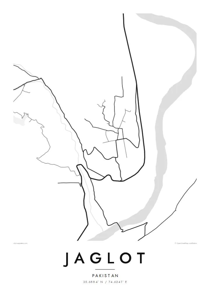
The main road runs the length of the valley and passes directly through Jaglot. On the map, it appears as a long, confident line connecting the region north and south.
Minimalističen plakat z zemljevidom · Pakistan
35.6884° N / 74.6241° E
A mountain town on the Karakoram Highway, beside the Indus near the point where three great ranges meet


Eno mesto, pet razpoloženj
Dotaknite se stila, da ga vidite na steni. Vsi stili stanejo enako — natisnjen, uokvirjen ali kot HD datoteke.
 Dejanski slikovni piki · datoteka za tisk 24 × 36″
Ostro za tisk
To je 100-odstotni izrez dejanske datoteke za tisk. Vsak poster — natisnjen, uokvirjen ali prenesen — izrišemo na naših strežnikih pri 300 DPI, do 7,200 × 10,800 slikovnih pik, tako da tudi najmanjše ulice ostanejo ostre na tisku 24 × 36″.
Na steni


Zemljevid
Jaglot lies in Gilgit-Baltistan, in a deep valley on the Karakoram Highway south of Gilgit. The Indus runs nearby, and the Gilgit River joins it close to the town. On a map, the settlement is a thin strip of streets and fields squeezed between river and mountainside, with the highway threading straight through.
Close to Jaglot, a viewpoint marks the meeting point of three mountain ranges: the Himalaya, the Karakoram and the Hindu Kush. The map shows the effect of this rugged terrain. Flat land exists only along the rivers. Terraced fields and villages sit on alluvial fans below steep slopes, and every road has to follow the valleys.
A Jaglot map poster makes this geography easy to read. The highway, the rivers and the narrow band of settlement form a few strong lines through otherwise empty mountain ground. In black and white, it gives a clear view of one of the most striking valley junctions in northern Pakistan.
The main road runs the length of the valley and passes directly through Jaglot. On the map, it appears as a long, confident line connecting the region north and south.
The Gilgit River meets the Indus close to the town. Their joining channels are the defining water feature of the whole composition.
A nearby viewpoint marks where the Himalaya, Karakoram and Hindu Kush meet. Around it, the map is mostly steep, uninhabited mountain ground.
Naj bo vaš
Dodajte datum, ime ali svoje besedilo, zamenjajte slog, velikost ali usmerjenost.
Brezplačen predogled je nizke ločljivosti in z vodnim žigom. Natisi in HD datoteke so izrisani pri 300 DPI, do 7,200 × 10,800 px, brez vodnega žiga.
Zakaj Jaglot
The poster suits travellers who have driven the Karakoram Highway, climbers heading to the northern peaks and families from Gilgit-Baltistan. Use the personalised title, subtitle and coordinates line to record a journey, a trek date or a home village.
Pick one of five styles: Classic black & white, Noir, Paper, Blueprint or Sand. The digital files are $9 for six sizes, each as a 300 DPI PNG and a print-ready PDF. Printed posters on matte paper ship from partners in more than 30 countries.
Naročite poster Jaglot| Velikost tiska | Ločljivost | Datoteke |
|---|---|---|
| 30 × 40 cm11.8 × 15.7″ | 3,543 × 4,724 px | PNG · PDF |
| 29.7 × 42 cm (A3)11.7 × 16.5″ | 3,508 × 4,961 px | PNG · PDF |
| 42 × 59.4 cm (A2)16.5 × 23.4″ | 4,961 × 7,016 px | PNG · PDF |
| 45.7 × 61 cm18 × 24″ | 5,400 × 7,200 px | PNG · PDF |
| 50 × 70 cm19.7 × 27.6″ | 5,906 × 8,268 px | PNG · PDF |
| 61 × 91.4 cm24 × 36″ | 7,200 × 10,800 px | PNG · PDF |
Za primerjavo: brezplačni predogled je širok 900 px, ima vodni žig in je namenjen zaslonom. Datoteke HD imajo do 8-krat večjo ločljivost v vsako smer in se čisto natisnejo v polni velikosti plakata.
Izberite stil na vrhu strani, nato izberite Natisnjen poster — velikost in, če želite, okvir — ali Digitalne HD datoteke. Nakup je zaključen v enem koraku, stran naročila pa se posodobi takoj, ko je plačilo izvedeno.
Natisnjen je na premium mat papir 200 gsm v eni od šestih velikosti, od 30 × 40 cm do 24 × 36″. Natisnjeni posterji se začnejo pri $39, vključno s dostavo.
Da. Izberite okvir iz masivnega lesa v črni, beli, naravni hrastovi ali temni lesni barvi. Ima nezlomljivo steklo in je pripravljen za obešanje. Uokvirjeni posterji se začnejo pri $99, vključno s dostavo.
Dostava je brezplačna v več kot 60 držav. Vsak plakat natisne najbližji od naših tiskarskih partnerjev v več kot 30 državah, običajno pa prispe v 3–7 delovnih dneh. Stanje in sledenje pošiljki lahko spremljate pod »Moja naročila«. Nekaj držav traja 2–5 tednov, tam, kamor še ne dostavljamo, pa vas stran na to opozori, preden plačate.
Pošljite nam fotografijo v 14 dneh po dostavi in ga bomo brezplačno ponovno natisnili ali vam povrnili denar.
Da. V urejevalniku na tej strani spremenite naslov, podnaslov in vrstico s koordinatami po želji ter izberite stil in velikost. Natisnjena, uokvirjena in digitalna naročila vsa uporabijo prav vaš dizajn.
Za $9 dobite PNG datoteke s 300 DPI in PDF datoteke, pripravljene za tisk, v vseh šestih velikostih, brez vodnega žiga, da jih lahko natisnete kjerkoli. Še niste prepričani? Najprej prenesite brezplačen predogled z vodnim žigom.
