Cliff-bound coastline
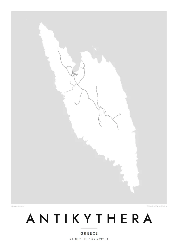
The shoreline is mostly steep rock, with only a few inlets where boats can approach. On the poster the edge of the island appears sharp and irregular, giving the landmass a clear, almost sculpted outline.
Bango la ramani la kisasa · Ugiriki
35.8644° N / 23.2989° E
A small, steep-sided island between Kythera and Crete, its rocky outline broken by a few coves and a single harbour.


Mji mmoja, hisia tano
Gusa mtindo ili kuuona ukutani. Mitindo yote yana bei sawa — iliyochapishwa, yenye fremu au kama faili za HD.
 Pikseli halisi · faili la kuchapisha 24 × 36″
Makali ya kuchapisha
Hii ni sehemu ya 100% ya faili halisi la kuchapisha. Kila bango — likiwa limechapishwa, lenye fremu au lililopakuliwa — huundwa kwenye seva zetu kwa 300 DPI, hadi pikseli 7,200 × 10,800, ili hata njia ndogo kabisa zibaki wazi kwenye uchapishaji wa 24 × 36″.
Ukutani


Ramani
Antikythera sits alone in the strait between Kythera and Crete, a compact wedge of limestone with very little flat ground. From above, the island reads as a rough, elongated shape fringed by cliffs, with a handful of tracks threading between a small harbour settlement and scattered hamlets. The sea takes up most of the frame, and the land becomes a single pale form surrounded by open water.
The island is known worldwide for what was found just offshore. At the start of the twentieth century, sponge divers came across an ancient shipwreck here, and among its cargo was the Antikythera mechanism, a geared bronze device often described as the oldest known analogue computer. The object is now kept in the National Archaeological Museum in Athens, but its name will always point back to this coastline.
An Antikythera map poster is an exercise in restraint. There is no dense grid to fill the paper, only a coastline, a thin network of roads and the contour of the island against a wide field of white or black. The result is quiet and graphic, a shape that people who know the island tend to recognise at once, and that others find simply striking.
The shoreline is mostly steep rock, with only a few inlets where boats can approach. On the poster the edge of the island appears sharp and irregular, giving the landmass a clear, almost sculpted outline.
A small sheltered cove on the northern side serves as the island's port and its link to the ferries. It is where the few roads converge, which makes it the natural focal point of the map.
The waters off the island hold the wreck that yielded the famous mechanism. Nothing marks the spot on a street map, yet the empty sea around the coast carries that story for anyone who knows it.
Ifanye iwe yako
Ongeza tarehe, jina au maneno yako mwenyewe, badilisha mtindo, saizi au mkao.
Onyesho la bure lina ubora wa chini na alama ya maji. Machapisho na faili za HD huundwa kwa 300 DPI, hadi px 7,200 × 10,800, bila alama ya maji.
Kwa nini Antikythera
Antikythera appeals to people who care about the history of science, to divers and sailors, and to anyone who has made the long ferry crossing to reach it. The poster is less about streets than about one island standing alone in open sea, a small object with an outsized story.
You can add your own title and subtitle, such as the date of a visit or a line about the mechanism, and adjust the coordinates line. Choose from Classic black & white, Noir, Paper, Blueprint or Sand; Blueprint suits the scientific theme particularly well. Download HD files for $9 or order a printed poster.
Agiza bango la Antikythera| Saizi ya kuchapisha | Ubora | Faili |
|---|---|---|
| 30 × 40 cm11.8 × 15.7″ | 3,543 × 4,724 px | PNG · PDF |
| 29.7 × 42 cm (A3)11.7 × 16.5″ | 3,508 × 4,961 px | PNG · PDF |
| 42 × 59.4 cm (A2)16.5 × 23.4″ | 4,961 × 7,016 px | PNG · PDF |
| 45.7 × 61 cm18 × 24″ | 5,400 × 7,200 px | PNG · PDF |
| 50 × 70 cm19.7 × 27.6″ | 5,906 × 8,268 px | PNG · PDF |
| 61 × 91.4 cm24 × 36″ | 7,200 × 10,800 px | PNG · PDF |
Kwa kulinganisha, hakikisho la bure lina upana wa px 900, lina alama ya maji na limekusudiwa kwa skrini. Faili za HD zina ubora hadi mara 8 zaidi kila upande na huchapishwa vizuri kwa saizi kamili ya bango.
Chagua mtindo juu ya ukurasa, kisha chagua Bango Lililochapishwa — ukubwa na, ukipenda, fremu — au Faili za Kidijitali za HD. Malipo huchukua hatua moja tu, na ukurasa wa agizo lako husasishwa mara malipo yanapokamilika.
Huchapishwa kwenye karatasi bora ya matte ya 200 gsm katika mojawapo ya ukubwa sita, kutoka 30 × 40 cm hadi 24 × 36″. Mabango yaliyochapishwa huanzia $39, ikijumuisha usafirishaji.
Ndiyo. Chagua fremu ya mbao thabiti katika rangi nyeusi, nyeupe, mwaloni wa asili au mbao nyeusi. Inakuja na kioo kisichovunjika na iko tayari kuning'inizwa. Mabango yenye fremu huanzia $99, ikijumuisha usafirishaji.
Usafirishaji ni bila malipo kwa nchi 60+. Kila bango huchapishwa na mshirika wetu wa uchapishaji aliye karibu zaidi nawe, kati ya nchi 30+, na kwa kawaida hufika ndani ya siku 3–7 za kazi. Unaweza kufuatilia hali na ufuatiliaji wa kifurushi katika Oda Zangu. Nchi chache huchukua wiki 2–5, na pale ambapo bado hatusafirishi, tovuti hukueleza kabla ya kulipa.
Tutumie picha ndani ya siku 14 baada ya kufika na tutalichapisha upya bila malipo au kukurejeshea pesa.
Ndiyo. Kwenye kihariri cha ukurasa huu, badilisha kichwa, kichwa kidogo na mstari wa kuratibu kuwa chochote unachopenda, kisha chagua mtindo na ukubwa. Maagizo yaliyochapishwa, yenye fremu na ya kidijitali yote hutumia muundo wako hasa.
Kwa $9 unapata faili za PNG za 300 DPI na PDF tayari kuchapishwa katika ukubwa wote sita, bila alama ya maji, ili uchapishe popote. Bado huna uhakika? Pakua kwanza onyesho la bure lenye alama ya maji.
Karibu
