Castle ruins
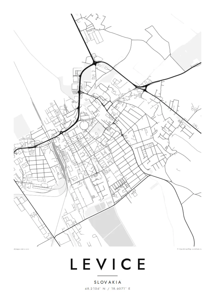
The remains of Levice Castle sit at the edge of the historic centre, and the streets around them bend to fit the old fortified site.
Bango la ramani la kisasa · Slovakia
48.2156° N / 18.6071° E
A southern Slovak town gathered around castle ruins, its streets opening onto the plain at the edge of the Hron valley


Mji mmoja, hisia tano
Gusa mtindo ili kuuona ukutani. Mitindo yote yana bei sawa — iliyochapishwa, yenye fremu au kama faili za HD.
 Pikseli halisi · faili la kuchapisha 24 × 36″
Makali ya kuchapisha
Hii ni sehemu ya 100% ya faili halisi la kuchapisha. Kila bango — likiwa limechapishwa, lenye fremu au lililopakuliwa — huundwa kwenye seva zetu kwa 300 DPI, hadi pikseli 7,200 × 10,800, ili hata njia ndogo kabisa zibaki wazi kwenye uchapishaji wa 24 × 36″.
Ukutani


Ramani
Levice lies in the Nitra Region of southern Slovakia, where the hills of central Slovakia give way to lowland. For centuries it was the seat of the historic Tekov county, and the ruins of Levice Castle still stand at the edge of the old town. From above, the historic centre forms a compact core, with newer housing districts spreading outward in larger, more regular blocks.
The town's layout shows the layers of its growth. Older streets curve around the castle area and the main square, while the outer neighbourhoods are laid out in the broader grid typical of twentieth-century expansion. Roads and a railway line lead out across the surrounding farmland toward neighbouring towns in the region.
A Levice map poster works well for anyone connected to this part of Slovakia, including the many families with ties to both Slovak and Hungarian heritage in the area. In black and white, the contrast between the tight historic core and the open fields around it gives the map a clear, balanced structure.
The remains of Levice Castle sit at the edge of the historic centre, and the streets around them bend to fit the old fortified site.
The central square and the streets that radiate from it form the densest part of the plan, a reminder of the town's role as a county seat.
Beyond the housing estates the map opens into wide agricultural land crossed by straight roads, framing the town within the lowland landscape.
Ifanye iwe yako
Ongeza tarehe, jina au maneno yako mwenyewe, badilisha mtindo, saizi au mkao.
Onyesho la bure lina ubora wa chini na alama ya maji. Machapisho na faili za HD huundwa kwa 300 DPI, hadi px 7,200 × 10,800, bila alama ya maji.
Kwa nini Levice
Levice is the kind of place people carry with them: a childhood town, a university stop, a family's home for generations. A map poster turns its streets into a calm, lasting reminder that fits any room.
Add a title, a subtitle and your own coordinates line, then choose Classic black & white, Noir, Paper, Blueprint or Sand. The result is a personal piece rather than a generic city print.
Agiza bango la Levice| Saizi ya kuchapisha | Ubora | Faili |
|---|---|---|
| 30 × 40 cm (11.8 × 15.7″) | 3,543 × 4,724 px | PNG · PDF |
| 29.7 × 42 cm (A3, 11.7 × 16.5″) | 3,508 × 4,961 px | PNG · PDF |
| 42 × 59.4 cm (A2, 16.5 × 23.4″) | 4,961 × 7,016 px | PNG · PDF |
| 45.7 × 61 cm (18 × 24″) | 5,400 × 7,200 px | PNG · PDF |
| 50 × 70 cm (19.7 × 27.6″) | 5,906 × 8,268 px | PNG · PDF |
| 61 × 91.4 cm (24 × 36″) | 7,200 × 10,800 px | PNG · PDF |
Kwa kulinganisha, hakikisho la bure lina upana wa px 900, lina alama ya maji na limekusudiwa kwa skrini. Faili za HD zina ubora hadi mara 8 zaidi kila upande na huchapishwa vizuri kwa saizi kamili ya bango.
Chagua mtindo juu ya ukurasa, kisha chagua Bango Lililochapishwa — ukubwa na, ukipenda, fremu — au Faili za Kidijitali za HD. Malipo huchukua hatua moja tu, na ukurasa wa agizo lako husasishwa mara malipo yanapokamilika.
Huchapishwa kwenye karatasi bora ya matte ya 200 gsm katika mojawapo ya ukubwa sita, kutoka 30 × 40 cm hadi 24 × 36″. Mabango yaliyochapishwa huanzia {printFrom}, ikijumuisha usafirishaji.
Ndiyo. Chagua fremu ya mbao thabiti katika rangi nyeusi, nyeupe, mwaloni wa asili au mbao nyeusi. Inakuja na kioo kisichovunjika na iko tayari kuning'inizwa. Mabango yenye fremu huanzia {framedFrom}, ikijumuisha usafirishaji.
Usafirishaji ni bure duniani kote. Kila bango huchapishwa na mshirika wetu wa uchapishaji aliye karibu zaidi katika nchi zaidi ya 30 na kwa kawaida hufika ndani ya siku 3–7 za kazi. Unaweza kufuatilia hali na ufuatiliaji chini ya Maagizo Yangu.
Tutumie picha ndani ya siku 14 baada ya kufika na tutalichapisha upya bila malipo au kukurejeshea pesa.
Ndiyo. Kwenye kihariri cha ukurasa huu, badilisha kichwa, kichwa kidogo na mstari wa kuratibu kuwa chochote unachopenda, kisha chagua mtindo na ukubwa. Maagizo yaliyochapishwa, yenye fremu na ya kidijitali yote hutumia muundo wako hasa.
Kwa $9 unapata faili za PNG za 300 DPI na PDF tayari kuchapishwa katika ukubwa wote sita, bila alama ya maji, ili uchapishe popote. Bado huna uhakika? Pakua kwanza onyesho la bure lenye alama ya maji.
