Ajinkyatara fort hill
The fort's plateau rises right beside the town. On the map the streets thin out and bend around its slopes, leaving a clear open shape that anchors the whole composition.
Bango la ramani la kisasa · India
17.6859° N / 73.9933° E
A hill-ringed Deccan town between the Krishna and Venna rivers, with a fort ridge rising directly above its streets


Mji mmoja, hisia tano
Gusa mtindo ili kuuona ukutani. Mitindo yote yana bei sawa — iliyochapishwa, yenye fremu au kama faili za HD.
 Pikseli halisi · faili la kuchapisha 24 × 36″
Makali ya kuchapisha
Hii ni sehemu ya 100% ya faili halisi la kuchapisha. Kila bango — likiwa limechapishwa, lenye fremu au lililopakuliwa — huundwa kwenye seva zetu kwa 300 DPI, hadi pikseli 7,200 × 10,800, ili hata njia ndogo kabisa zibaki wazi kwenye uchapishaji wa 24 × 36″.
Ukutani


Ramani
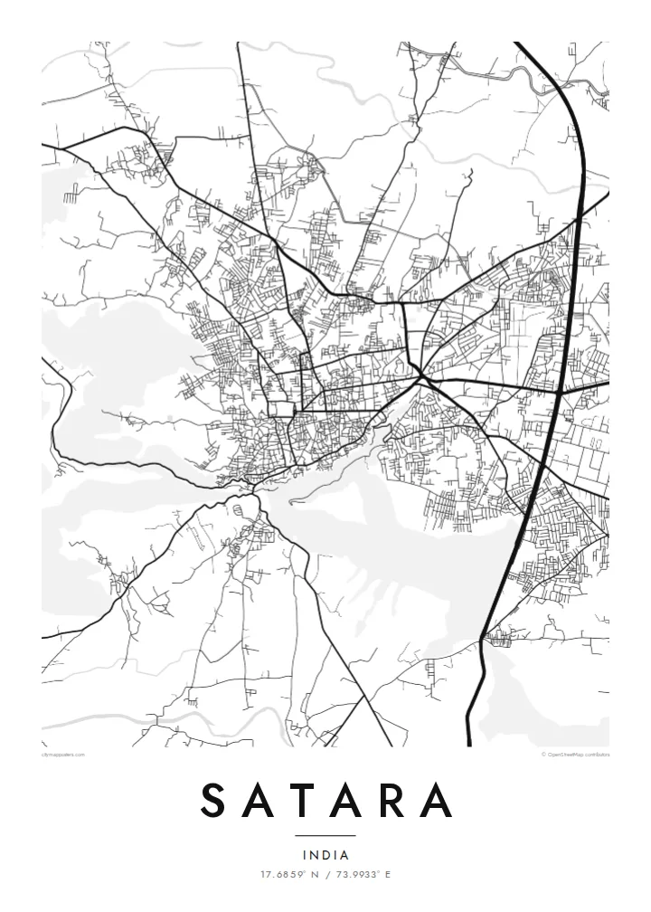
Satara sits in a bowl of the Western Ghats foothills, close to where the Venna joins the Krishna. From above, the town spreads across fairly level ground and stops where the slopes begin, so the edges of its street network follow the contours of the hills around it. Ajinkyatara, the fort that overlooks the city, shows on the map as a flat-topped ridge pressing against the edge of town.
Satara matters in Maratha history. In the eighteenth century it was the seat of the Chhatrapati line descended from Shivaji. The older quarters still have the dense, irregular lanes of a courtly town rather than a planned grid. Newer neighbourhoods and the main highway corridor spread outward in straighter lines, so the map has two distinct textures side by side.
A Satara map poster also has room for the landscape beyond the town. To the west, the Kaas plateau, known for the wildflowers that cover it after the monsoon, sits high on the escarpment, and roads climb toward it in tight switchbacks. Drawn in fine black lines, the river, the fort hill and the winding ghat roads make a composition that is clearly tied to its terrain.
The fort's plateau rises right beside the town. On the map the streets thin out and bend around its slopes, leaving a clear open shape that anchors the whole composition.
Two rivers meet near the city. Their curving channels add soft, organic lines to the map, a counterpoint to the compact and busy street pattern of the town itself.
Roads heading west toward the Sahyadri escarpment fold into tight hairpins as they climb, a pattern that reads almost like handwriting when printed in thin black line.
Ifanye iwe yako
Ongeza tarehe, jina au maneno yako mwenyewe, badilisha mtindo, saizi au mkao.
Onyesho la bure lina ubora wa chini na alama ya maji. Machapisho na faili za HD huundwa kwa 300 DPI, hadi px 7,200 × 10,800, bila alama ya maji.
Kwa nini Satara
For people from Satara, and for those who have passed through on the way to the Kaas plateau or Mahabaleshwar, this map shows a familiar geography of fort, river and hills. It works as a quiet reminder of home, of student years, or of a monsoon trek.
You can set your own title, subtitle and coordinates line, adding a family name or a date, and choose from five styles: Classic black & white, Noir, Paper, Blueprint or Sand. You can download HD files for $9 or order a matte print with an optional wooden frame.
Agiza bango la Satara| Saizi ya kuchapisha | Ubora | Faili |
|---|---|---|
| 30 × 40 cm (11.8 × 15.7″) | 3,543 × 4,724 px | PNG · PDF |
| 29.7 × 42 cm (A3, 11.7 × 16.5″) | 3,508 × 4,961 px | PNG · PDF |
| 42 × 59.4 cm (A2, 16.5 × 23.4″) | 4,961 × 7,016 px | PNG · PDF |
| 45.7 × 61 cm (18 × 24″) | 5,400 × 7,200 px | PNG · PDF |
| 50 × 70 cm (19.7 × 27.6″) | 5,906 × 8,268 px | PNG · PDF |
| 61 × 91.4 cm (24 × 36″) | 7,200 × 10,800 px | PNG · PDF |
Kwa kulinganisha, hakikisho la bure lina upana wa px 900, lina alama ya maji na limekusudiwa kwa skrini. Faili za HD zina ubora hadi mara 8 zaidi kila upande na huchapishwa vizuri kwa saizi kamili ya bango.
Chagua mtindo juu ya ukurasa, kisha chagua Bango Lililochapishwa — ukubwa na, ukipenda, fremu — au Faili za Kidijitali za HD. Malipo huchukua hatua moja tu, na ukurasa wa agizo lako husasishwa mara malipo yanapokamilika.
Huchapishwa kwenye karatasi bora ya matte ya 200 gsm katika mojawapo ya ukubwa sita, kutoka 30 × 40 cm hadi 24 × 36″. Mabango yaliyochapishwa huanzia $39, ikijumuisha usafirishaji.
Ndiyo. Chagua fremu ya mbao thabiti katika rangi nyeusi, nyeupe, mwaloni wa asili au mbao nyeusi. Inakuja na kioo kisichovunjika na iko tayari kuning'inizwa. Mabango yenye fremu huanzia $99, ikijumuisha usafirishaji.
Usafirishaji ni bure duniani kote. Kila bango huchapishwa na mshirika wetu wa uchapishaji aliye karibu zaidi nawe, katika nchi zaidi ya 30, na kwa kawaida hufika ndani ya siku 3–7 za kazi. Unaweza kufuatilia hali ya agizo na ufuatiliaji wa kifurushi katika Maagizo Yangu. Nchi chache huchukua wiki 2–5, na pale ambapo bado hatusafirishi, tovuti inakuambia kabla ya kulipa.
Tutumie picha ndani ya siku 14 baada ya kufika na tutalichapisha upya bila malipo au kukurejeshea pesa.
Ndiyo. Kwenye kihariri cha ukurasa huu, badilisha kichwa, kichwa kidogo na mstari wa kuratibu kuwa chochote unachopenda, kisha chagua mtindo na ukubwa. Maagizo yaliyochapishwa, yenye fremu na ya kidijitali yote hutumia muundo wako hasa.
Kwa $9 unapata faili za PNG za 300 DPI na PDF tayari kuchapishwa katika ukubwa wote sita, bila alama ya maji, ili uchapishe popote. Bado huna uhakika? Pakua kwanza onyesho la bure lenye alama ya maji.
Karibu
